Section B1(a) Flood Management - pre 2019 flood studies
Flood management is an essential aspect of land use planning and development. Flooding affects up to one third of all properties in the local government area (LGA), and can cause significant damage to property and infrastructure, disrupt the community and threaten public safety. Many old swamplands and floodplains are developed. Development needs to respond to the local environment as well as future intensifying flood risks associated with climate change.
This section applies to all development on flood prone (flood liable) land that involves existing flood mapping undertaken prior to the release of the 2019 Australian Rainfall and Runoff Guidelines (ARR 2019).
Flood prone (flood liable) land is defined by the NSW Government Floodplain Development Manual – the management of flood liable land (2005), being “land susceptible to flooding by the Probable Maximum Flood (PMF) event”.
A flood information application form can be obtained from www.newcastle.nsw.gov.au or the Customer Contact Centre, 12 Stewart Avenue, Newcastle West NSW 2302.
This section applies to all development on flood prone land with the exception of minor additions to existing buildings.
Minor additions (refer to definitions) are allowable without further reference to the provisions of this section, provided that the flood risk is not unreasonably increased.
Tsunami and very minor nuisance flooding (such as the trapping of surface runoff in a road shoulder or against a building) are specifically excluded from the application of this section.
- Guide the development of flood prone land, applying balanced strategies to economically, socially and environmentally manage risk to life and property.
- Set aside appropriate areas to convey and/or store flood waters.
- Ensure development, when considered both individually and as an instance of cumulative development trends, will not cause unreasonable adverse flooding impacts in other locations.
- Implement the principles of The NSW Government Floodplain Development Manual (2005) to development as applicable.
A word or expression has the same meaning as it has in Newcastle Local Environmental Plan 2012 (LEP 2012), unless otherwise defined. Other words and expressions include:
- Annual exceedance probability (AEP) – is the probability that a flood of a given or larger magnitude will occur within a period of one year. Its reciprocal is equivalent to average recurrence interval (ARI).
- Average recurrence interval (ARI) – is the average period between the recurrence of a storm event of at least a given rainfall intensity. The ARI represents a statistical probability. For example, a 10 year ARI indicates an average of 10 events over 100 years. The ARI is not the period between actual events.
- Basement garage – is a garage normally used to park vehicles with its floor below the street level.
- Flood fringe areas – means the remaining area of flood prone land not included in flood storage areas and floodways. Flood fringe areas can usually be developed without reference to how that development will affect the flood behaviour either upstream or downstream.
- Flood information certificate – is a certificate issued by City of Newcastle (CN) that provides information about the likelihood, extent or other characteristics of flooding known to affect a specified parcel of land.
- Flooding– is relatively high stream flow which overtops the natural or artificial banks in any part of a stream, river estuary, lake or dam, and/or local overland flooding associated with major drainage, and/or coastal inundation resulting from super-elevated sea levels and/or waves, excluding tsunami. Flooding may occur for a variety of reasons, either separately or in combination including:
- river flooding - caused by a river or stream overtopping its banks onto a surrounding floodplain
- urban flooding - caused by urban stormwater flows during an intense rainfall event, such as surface flows, surcharge from piped drainage systems or overflow from manmade stormwater channels.
- coastal inundation - caused by sea water inundation due to king tides, storm surge, barometric effects, shoreline recession, subsidence, the enhanced greenhouse effect or other causes.
- Flood liable land – also flood prone land is land susceptible to flooding by the PMF event on the basis of flood information held by CN. Note the term flood liable land covers the whole floodplain, not just that part below the flood planning area (FPL).
- Floodplain – is an area of land along the course of a river subject to periodic inundation due to the river overtopping its bank. It is commonly delineated by the area that would be flooded by an event with a given average recurrence interval.
- Flood planning area – the area of land below the FPL. Note development controls that mainly relate to risk to property apply to the flood planning area, but other development controls mainly relating to risk to life and floodways and flood storages may apply to the remainder of flood liable (prone) land.
- Flood planning level (FPL) – is the level of the planning flood area plus an additional freeboard as advocated in the NSW Floodplain Development Manual. For purposes of this element, the planning flood is the 1% AEP flood, and the freeboard is generally 500mm.
- Flood prone land – is land that, on the basis of flood information held by CN, is estimated to be inundated by the probable maximum flood (PMF).
- Flood refuge – is an area free of flooding. It can be either higher ground or it could be in the form of an area of the building, either constructed specifically for the purpose or as an intrinsic part of the building.
- Flood storage area – is an area where flood water accumulates and the displacement of that floodwater will cause a significant redistribution of floodwaters, or a significant increase in flood levels, or a significant increase in flood frequency. Flood storage areas are often aligned with floodplains and usually characterised by deep and slow-moving floodwater.
- Floodway – those areas of the floodplain where a significant discharge of water flows during floods; often aligned with naturally defined channels. Floodways are areas which, even if only partially blocked, would cause a significant redistribution of flood flow or increase in flood levels, which may in turn adversely affect other areas.
- Freeboard – is a margin applied to the estimation of flood levels to compensate for factors such as wave action, localised hydraulic behaviour, climatic change and modelling confidence.
- Hydraulic behaviour threshold – is a set of circumstances (that may or may not be present at some locations at some time in any particular sized flood) that constitutes a particular level of hydraulic impact, as specified below:
H1 | hydraulically suitable for parked or moving cars V < 0.5m/sec and d < 0.3m |
H2 | hydraulically suitable for parked or moving heavy vehicles and wading by able-bodied adults V < 2m/sec, d< 0.8m and v < 3.2 – 4*d |
H3 | hydraulically suitable for light construction (eg. timber frame and brick veneer) v < 2m/sec, d < 2m, v*d < 1 |
H4 | hydraulically suitable for heavy construction (eg. steel frame and reinforced concrete) v < 2.5m/sec, d < 2.5m and v*d < 2.5 |
H5 | generally unsuitable |
- Life hazard – is the ‘risk to life hazard category’ as a combination of hydraulic hazard category, warning time and escape path availability, applied to all floods, up to and including the PMF (as required by the NSW Government Floodplain Development Manual (2005) for the management of personal safety). For simplicity, the Life Hazard categories set out below are only assessed at the PMF in the application of this section of Development Control Plan 2023 (DCP 2023), on the assumption that once the PMF is managed for personal safety, all other lesser floods will also be managed. The life hazards “L1” to “L5” are defined below∗:
Hydraulic Behaviour Threshold
H1 | H2 | H3 | H4 | H5 | ||||
| Catchment Response Time | Riverine | L1 | ||||||
| Flash | Escape Route to flood free land | available | L2 | L4 | L5 | |||
| not available | L3 | |||||||
- Minor additions – (for the purpose of section B1 Flood Management) are additions that fall below the following limits:
Existing building area | Minor addition limit |
< 250m2 | 50m2 |
250m2 – 750m2 | 20% of the existing building area |
>750m2 | 150m2 |
- Occupiable rooms – are rooms of buildings where people may be present in the normal use of the building.
- Planning flood – is the flood event from which the FPL is derived. It is expressed in terms of the probability of the event being exceeded, usually within any given year (see AEP).
- Probable maximum flood (PMF) – is the largest flood that could conceivably occur at a particular location.
- Probable maximum flood level – is the flood level calculated to be the maximum which is likely to occur.
- Property hazard – is the ‘risk to property hazard category’ as a combination of hydraulic behaviour threshold and its effect on property. The risk to property hazards are based on the peak hydraulic behaviour thresholds (H1-H5) determined for the 1% AEP event. Five risks to property hazard categories (P1-P5) are defined as P1-P5 correlate directly with H1-H5 as follows:
P1 | Parked or moving cars remain stable i.e., equivalent to areas of H1 at the Flood Planning Event. |
P2 | Parked or moving heavy vehicles remain stable i.e., equivalent to areas of H2 at the Flood Planning Event. |
P3 | Suitable for light construction (eg. timber frame, masonry and brick veneer) i.e., equivalent to areas of H3 at the Flood Planning Event. |
P4 | Suitable for heavy construction (eg. steel frame, reinforced concrete) i.e., equivalent to areas of H4 at the Flood Planning Event. |
P5 | Hydraulically unsuitable for normal building construction is equivalent to areas of H5 at the Flood Planning Event. |
The distribution of P1-P5 is identical to the related H1-H5 (at the Flood Planning Event).
- Tsunami – means a series of ocean waves with very long wavelengths (typically hundreds of kilometres) caused by large-scale disturbances of the ocean, such as: - earthquakes - landslide - volcanic eruptions - explosions - meteorites.
| Notes: Tsunami are specifically excluded |
Development category | Application requirements | Additional information |
All development on flood prone land | A statement of environmental effects and/or layout plans shall include wording and where relevant, calculations, demonstrating that the controls of this section of DCP 2023 have been addressed. | All development on flood prone land shall be designed in accordance with the flood controls in LEP 2012. The NSW Government Floodplain Development Manual – the management of flood liable land (2005) is available from the NSW Government website. More information about floodplain risk management in the LGA can be found at CN's website. A Flood Information Certificate application form can be obtained from www.newcastle.nsw.gov.au or the Customer Contact Centre, 12 Stewart Avenue, Newcastle West NSW 2302. |
Objectives
- Retain floodways in a condition capable for the conveyance of essential flood flow.
Controls (C) | Explanatory notes |
C-1. No building or structure can be built, and no land can be filled with any materials in areas identified as floodways, except for small changes to ground levels that do not significantly change the flow patterns for:
| Fill is identified in LEP 2012. Floodways are shown on a flood information certificate obtainable on application. In general, development other than low level driveways and parking areas is not practicable in floodways. Floodways are not necessarily indicative of high hazard flow, although the two will generally coincide. It is necessary to separately investigate hazard in order to determine if parking areas and the like are suitable within floodways. |
C-2. Where dividing fences across floodways are unavoidable, they are constructed only of open type fencing that does not restrict the flow of flood waters and are resistant to blockage. New development is designed to avoid fences in floodways. |
|
Objectives
- Protect flood storage areas to provide storage of floodwaters to ensure that other areas are not significantly worse off due to development of the site.
Controls (C) | Explanatory notes |
C-1. Not more than 20% of the area of any development site in a flood storage area is filled. The remaining 80% is generally developed allowing for underfloor storage of floodwater by the use of suspended floor techniques such as pier and beam construction. Where a development is proposing to build over more than 20% of the site area, the portion of the structure being suspended is to have a floor level at the FPL as a minimum. As part of the structure's design, it must allow water to flow freely into and out of the underfloor area and must not be restricted by solid cladding or similar around the perimeter of the structure below the floor level. | Flood storage areas are identified on the flood information certificate. |
C-2. Where it is proposed to fill development sites, the fill does not impede the flow of ordinary drainage from neighbouring properties, including overland flow. |
|
Objectives
- Manage risks to property up to an acceptable level of risk (the FPL).
Controls (C) | Explanatory notes |
C-1. Floor levels of all occupiable rooms of all buildings are not set lower than the FPL. | These controls limits the risk of inundation relative to the FPL. The FPL is the water surface level of the relevant 'planning flood' plus a freeboard. Compliance with the FPL does not guarantee that flooding will not affect work carried out in accordance with Risk to Property Development Controls: In most cases, the FPL, and the property hazards are given on the flood information certificate for the relevant property. The “planning flood” for all development in all areas of Newcastle is the 1% AEP event where this level is known. |
C-2. Garage floor levels are no lower than the 1% AEP Event. However, it is recognised that in some circumstances this may be impractical due to vehicular access constraints. In these cases, garage floor levels are as high as practicable. | |
C-3. Basement garages may be acceptable where all potential water entry points are at or above the PMF, excepting that vehicular entry points can be at the FPL. In these cases, explicit points of refuge are accessible from the carpark in accordance with the controls for risk to life set out below. | |
C-4. Electrical fixtures such as power points, light fittings and switches are sited above the FPL unless they are on a separate circuit (with earth leakage protection) to the rest of the building. | |
C-5. Swimming pools are to be located to ensure they are not inundated from minor flooding events. Electrical connections and fixtures around swimming pools are to be sited at the FPL. | |
C-6. Where parts of the building are proposed below the FPL, they are constructed of water-resistant materials. | |
C-7. Areas where cars, vans and trailers are parked, displayed or stored are not located in areas subject to property hazard of P2 or higher. Containers, bins, hoppers and other large floatable objects also are not stored in these areas. Heavy vehicle parking areas are not located in areas subject to property hazard P3 or higher. | |
C-8. Timber framed, light steel construction, cavity brickwork and other conventional domestic building materials are generally not suitable forms of construction where the property hazard is P4 or higher. Where property hazard is P4, the structure is certified by a practising structural engineer to withstand the hydraulic loads (including debris) induced by the flood waters. | |
C-9. Property hazards of P5 are generally unsuitable for any type of building construction and building is discouraged from these areas. Where building is necessary, the structure is certified by a practising structural engineer to withstand the hydraulic loads (including debris) induced by the flood waters. |
Objectives
- Only permit development or redevelopment where the full potential risk to life from flooding can be managed for all floods up to and including the PMF.
Controls (C) | Explanatory notes |
C-1. Risk to life category L5 Risk to life hazards of L5 are generally unsuitable for any type of building construction and building is discouraged from these areas. Reliable safe escape to high ground is likely not possible and normal building construction would likely suffer structural failure from the force of floodwaters, so that any people seeking refuge in the building would likely perish. Where building is necessary, the structure is certified by a practising structural engineer to withstand the hydraulic loads (including debris) induced by the flood waters. |
|
C-2. Islands The formation of islands in the floodplain during a flood is a potentially dangerous situation, especially when floods larger than the FPL totally inundate the island for an extended period. Development of such land is considered with great care. |
|
C-3. On-site refuge On-site refuge is to be provided for all development where the life hazard category is L4 unless the proposed development is less than 40m from the perimeter of the PMF extent and the higher ground is accessible. | Refuge can be in the form of on-site refuge or convenient access to flood free ground. In general, it is not acceptable to rely on refuge provided by or on other development sites. In all cases where on site refuge is provided, it is to be both intrinsically accessible to all people on the site and an integrated part of the development (eg. a second storey with stair access). The route to the refuge is to be fail safe, plainly evident and self-directing. In most cases, life hazard categories are nominated on the flood information certificate for the relevant property. The life risk hazard category “L1” assumes people will respond to warnings and safely evacuate to the safety flood free high ground. Additional requirements may be necessary to manage personal safety in riverine flooding if there is evidence that a lack of response is likely, and this may lead to life threatening situations. |
C-4. Standards for on-site refuge Where on-site refuge is required for a development, it should comply with the following minimum standards:
| In most cases, the potential risk to life hazards categories are given on the flood information certificate for the relevant property.
|
C-5. Emergency egress procedure for basements A plan is developed detailing emergency egress procedures during a flood, as well as any refuge areas in reasonable proximity of the development. The plan is to be positioned in the basement car park in an easily recognisable location/s. Refer to Figure B1(a).01.  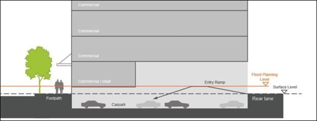 Figure B1(a).01: Basement ramp design to minimise inundation Figure B1(a).01: Basement ramp design to minimise inundation |
|