Section C5 Soil management
Newcastle's natural topography and landform features are a fundamental part of the character and attractiveness of the area. Maintaining the natural landform should be an integral consideration of the overall design.
Healthy soil that is nourished and nutrient-rich can increase climate change resilience, reduce runoff, reduce flooding risk, and support biodiversity and environmental health during periods of low rainfall. Healthy, moisture-rich soil supports our ecosystem and trees to transpire at maximum efficiency, allowing for cooling of the urban environment and combating the urban heat island effect, and supporting healthy environments and communities.
Potential for soil erosion occurs when vegetation cover is removed during the demolition or construction of buildings and structures, or where it is proposed to recontour the existing landform. As a result, sediment can enter the natural and stormwater catchments and drainage systems, and can potentially block their flow, reduce their capacity and eventually be deposited in receiving waters.
Sediment reduces water depth, causes turbidity, reduces recreational amenity and damages aquatic systems. Sediment can also have a destructive impact on the quality of urban bushland. Sedimentation represents a considerable cost to the community in cleaning and maintenance of stormwater infrastructure. Efficient sediment control techniques have benefits to the builder as well as the community, in improved access and site conditions and less time lost due to waterlogged sites.
Acid sulfate soils are a concern, particularly in low-lying areas and where significant excavation is proposed. If exposed, this acid, can kill plants and animals, contaminate drinking water and food such as oysters, and corrode concrete and steel. Requirements for when investigation is needed as part of a development application (DA) is found in clause 6.1 Acid sulfate soils, of the Newcastle Local Environmental Plan 2012 (LEP 2012).
This section applies to all earthworks, as defined in the LEP 2012, that result in disturbance of the soil. It also provides guidance for earthworks that are ancillary to development, including demolition works.
- Protect and enhance the aesthetic quality provided by the natural topography and landform features of the area by controlling the land forming operations to appropriate levels.
- Prevent pollution to waterways from construction sediment and waste streams.
- Minimise the potential for landslip on sloping sites.
- Ensure that development does not disturb, expose or drain acid sulfate soils and cause environmental damage.
A word or expression has the same meaning as it has in LEP 2012, unless otherwise defined. Other words and expressions include:
- Clean water diversion - is a structure or control that intercepts clean runoff upstream of a project site or disturbed area and directs the clean runoff around rather than through the project site or disturbed area.
- Flocculant - is a substance that causes colloidal particles to clump into larger units or ‘flocs’ that can either settle in a reasonable time or be filtered.
- Pit baskets - are a device placed inside a stormwater pit used to collect sediments and/or gross pollutants, stopping them from being conveyed into downstream waterways.
- Receiving waters - are waters into which water discharges flow from an activity.
- Sediment basin – is a basin or tank in which stormwater containing settleable solids is retained to remove by gravity or filtration a part of the suspended matter.
- Urban heat island effect - is the tendency of cities to be much warmer than their rural counterparts. Urban surfaces such as roads and roofs absorb, hold, and re-radiate heat; raising the temperature in our urban areas. Human activities such as traffic, industry, and electricity usage also generate heat that adds to the urban heat island effect.
- Virgin excavated natural material (VENM) –is natural material, such as clay, gravel, sand, soil or rock fines that:
- has been excavated or quarried from areas that are not contaminated with manufactured chemicals or process residues, as a result of industrial, commercial, mining or agricultural activities
- does not contain any sulfidic ores or soils or any other waste
- includes excavated natural material that meets such criteria for virgin excavated natural material as may be approved by the NSW Environment Protection Authority (EPA).
Development proposals are grouped into categories, which determine the level of information required with a DA.
Development category | Application requirements | Explanatory notes | |
Category 1: Works where land disturbance is less than 250m2. Works in this category include, for example: house extensions, landscaping, swimming pool installation, driveways, garages. | No formal Erosion and Sediment Control Plan is required. | Works in this category have potential to cause sediment pollution to waterways. Although no formal Erosion and Sediment Control Plan is required for development of this scale, the person conducting works should determine the need for and implement appropriate sediment control prior to works, and exercise reasonable care to prevent land degradation or pollution to local drains and waterways. | |
Category 2: Works where land disturbance is greater than 250m2 but less than 2500m2. Works in this category include, for example: dwelling house, commercial or industrial developments, medium to high density housing and civil works. | Submit an Erosion and Sediment Control Plan for approval. The Erosion and Sediment Control Plan must include as a minimum:
| Works is this category have significant potential to cause sediment pollution to waterways. Managing Urban Stormwater: Soils and Construction 4th Edition - Vol. 1 (the ‘Blue Book’) published by Landcom, 2004, provides support for councils and industry to reduce the impacts of land disturbance activities on waterways by better management of soil erosion and sediment control. The Blue Book can be sourced on the NSW Department of Planning and Environment website. The Blue Book "Chapter 6 Sediment and Waste Control" provides information on specific erosion and sediment controls to aid developers, builders, and designers. The Blue Book "Chapter 8 Maintenance" contains information on maintenance measures to be undertaken on all land disturbance sites. The onus is on the persons planning and undertaking the works to assess the site size and activity, to determine the need for further erosion and sediment controls in accordance with the best practice advice provided in the Blue Book (as amended), including but not limited to: staged works to minimise site disturbance, protecting stormwater drain inlets, installing clean water diversions, the use of sediment basins, and promptly revegetating completed areas. | |
Category 3: Works where land disturbance is greater than 2500m2. Works in this category include, for example, large medium/high density housing, commercial or industrial developments, sub-division works and large civil works. | Submit a Soil and Water Management Plan for approval. A Soil and Water Management Plan must include as a minimum all of the information required for an Erosion Sediment Control Plan, with the addition of:
The Plan is to include a Statement of Compliance. The Statement of Compliance must state that:
| Works in this category have a high risk of causing sediment pollution to waterways. A Soil and Water Management Plan is a documented site plan, that includes all the components of an Erosion Sediment Control Plan (outlined above), plus additional measures to account for the larger size of the site, to mitigate soil erosion, and control sediment pollution to downslope lands and water. The requirements may be varied for a Soil and Water Management Plan, especially where there is a higher or lower risk of polluting receiving waters. Further information may be required for any site depending on, but not limited to, the calculated soil loss, sediment type and an assessment of site constraints and opportunities. Water quality targets to be met prior to discharge as outlined in the ANZECC Water Quality Guidelines (2000) include but are not limited to:
A copy of the Soil and Water Management Plan, plus records of testing water prior to discharge (to demonstrate water quality compliance) should be maintained on site and be made available to a CN Authorised Officer should they request copies. | |
A site specific geotechnical assessment report (prepared by a suitably qualified geotechnical engineer), for the proposal will be required for sites with any or all of the following:
| The report must be in accordance with the principles described in the Australian Geomechanics Society Practice Note Guidelines for Landslide Risk Management 2007 that confirms that the proposed development will result in a low (preferred) to medium (justification required, must include detailed site management options to reduce the risk to low post development) risk in line with this document. | Practice Note Guidelines for Landslide Risk Management 2007 can be sourced on the landsliderisk.org website. | |
Where required under clause 6.1 Acid sulfate soils, of LEP 2012, an acid sulfate soils management plan or preliminary assessment of the proposed works will be required. | A Preliminary Assessment of proposed works will address the following (pg.11, Acid Sulfate Soils Assessment Guidelines, 1998):
An acid sulfate soils management plan should be prepared in accordance with the Acid Sulfate Soils Assessment Guidelines, 1998. Requirements can be summarised as follows (pg. 50, Acid Sulfate Soils Assessment Guidelines, 1998):
| The Acid Sulfate Soils Assessment Guidelines, 1998 can be found on the CN website. |
Objectives
- Protect the environment against soil erosion and loss of soil from construction sites.
- Prevent the loss of soil from the site through implementation of erosion and sediment control measures when undertaking construction and earthworks activities.
- Minimise site disturbance during construction, reduce the amount of erosion, and stabilise construction works as quickly as possible following completion.
- Prevent the degradation of drainage systems, waterways and aquatic environments from deposition of soil and foreign material from construction sites.
- Prevent flood damage for individual properties caused by sediment reducing the flow capacity of the stormwater drainage system.
- Reduce maintenance costs on existing stormwater infrastructure.
Controls (C) | Acceptable solutions (AS) | Explanatory notes |
C-1. Erosion and sediment controls are:
| AS-1. Erosion and sediment controls comply with the Blue Book (as amended). | In cases where works fail to implement erosion and sediment control, and cause sediment pollution, on the spot penalty infringements can be issued. Managing Urban Stormwater: Soils and Construction 4th Edition - Vol. 1 (the ‘Blue Book’) published by Landcom, 2004, provides support for councils and industry to reduce the impacts of land disturbance activities on waterways by better management of soil erosion and sediment control. The Blue Book can be sourced on the NSW Department of Planning and Environment website. |
C-2. The construction stage ensures suitable controls and practices are undertaken to control dust pollution from works, to protect adjoining residents, and protect air quality and public health. |
| The risk of causing dust pollution varies depending on weather, wind, the amount of exposed soil, the type of soil and the activity being conducted. A person conducting works is expected to plan and prepare for dust management to maintain air quality to public health standards and prevent nuisance impacts to nearby residents and properties. |
Objectives
- Inform the preparation of an acid sulfate soils management plan or preliminary assessment of the proposed works in accordance with LEP 2012.
Controls (C) | Explanatory notes |
C-1. Where required under clause 6.1 Acid sulfate soils, of LEP 2012, prepare an acid sulfate soils management plan or preliminary assessment of the proposed works in accordance with the application requirements above. | LEP 2012 sets out the requirements for when an acid sulfate soils management plan is required. An acid sulfate soils management plan may not be required if a preliminary assessment of the proposed works is undertaken, and shows that the proposed works will not require the preparation of an acid sulfate soils management plan. |
Objectives
- Encourage site responsive development and protect the amenity of adjoining land.
- Avoid excessive earthworks and minimise changes to the natural landform.
- Limit the extent of retaining walls, excavation and fill within development projects for aesthetic, character, engineering and geotechnical reasons.
- Avoid slab on ground construction where the gradient and characteristics of the site would require major excavation or filling.
Controls (C) | Acceptable solutions (AS) | Explanatory notes | |
C-1. Development is designed to:
| AS-1. Development is consistent with Figure C5.01 and Figure C5.02. AS-2. Development minimises the amount of cut and fill required, with maximum acceptable:
AS-3. Buildings are designed to relate to the existing topography with minimal excavation or fill and the height of foundations kept to a minimum. AS-4. No cut or fill takes place within easements. AS-5. If fill is to be used it is VENM. AS-7. Storm water / surface water runoff as a result of earthworks is not to be redirected or concentrated onto adjoining properties so as to cause a nuisance | The topography and existing land form of the site are important to the character of an area. Where the site has a sloped topography, building design should be characterised by a split level approach where floor levels are stepped to follow the topography of the land. Large areas of cut and fill should be avoided so that the finished ground floor level can be close to existing ground level. Under the Protection of the Environmental Operations Act 1997, if landfill contains material other than VENM, a certificate may be needed before using it as fill. Further information can be found on the NSW EPA website. | |
C-2. Owners of retaining walls have clear ownership and maintenance obligations. | AS-1. Retaining walls are located clear of lot boundaries to ensure clear ownership and maintenance obligations for owners. AS-2. Retaining wall subsoil drainage is accommodated entirely within the property(ies). |
| |
C-3. Retaining walls have a high aesthetic quality. | AS-1. If a retaining wall has a height of more than 600mm above ground level (existing) and is located within the front setback of a building, a landscaped area with a minimum depth of 600mm is provided in front of the wall (on the low side). |
| |
C-4. Development minimises the potential for landslip on sloping sites. | AS-1. Support for earthworks more than 600mm above or below ground level (existing) must take the form of a retaining wall or other structural support. AS-2. The implementation of suitable drainage systems and landscaping to assist in stabilising changes to landform from cut and fill practices is also required. |
| |
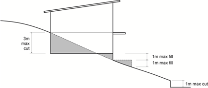 Figure C5.01: Maximum cut and fill Figure C5.01: Maximum cut and fill | 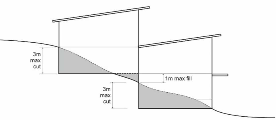 Figure C5.02: Minimise cut and fill by stepping building Figure C5.02: Minimise cut and fill by stepping building | ||