Section C2 Movement networks
Development generates vehicle and pedestrian movements. Transport networks and systems in our city connect us to key destinations and provide the structural framework from which to grow and expand. As our city continues to grow and transform, it is important for workers, residents and visitors to be able to move quickly, easily and comfortably within and between places and precincts. This demand is usually accommodated by the existing or planned movement network for smaller scale developments. However, larger scale developments may require changes to the movement network to satisfy the anticipated transport needs of the development.
It is recognised that well-functioning movement networks facilitate a vital economy. They help create vibrant, socially connected and inclusive communities. A well-functioning movement network requires efficient transport of freight and services, residents with access to business and commercial centres, and to sporting and leisure areas. It also relies on the support of public transport use and encouraging healthy lifestyles through active transport connection.
This section applies to all development.
The following section may also apply to development:
Associated technical manuals:
- Austroads Publications and Guides
- Disability Standards for Accessible Public Transport, 2002, Commonwealth of Australia (as amended)
- Transport Stops, Shelters and Seating Guidelines, 2019, City of Newcastle
- Newcastle Cycling Plan 2021 – 2030, City of Newcastle
- NSW Address Policy and User Manual, 2021, Geographical Names Board of New South Wales
- Model Agreement for Local Councils and Utility/Service Providers, 2018, NSW Streets Opening Coordination Council
- Guide to Codes & Practices for Streets Opening, 2018, NSW Streets Opening Coordination Council
Additional information:
- Planning Guidelines for Walking and Cycling, 2004, Department of Planning
- Guidelines for Public Transport Capable Infrastructure in Greenfield Sites, 2018, Transport for NSW
- Provide for all modes of travel through increased connectivity, legibility, and permeability.
- Ensure that development incorporates access to shaded, efficient and safe active and public transport options that are attractive and aim to reduce private vehicle dependency.
- Ensure the movement network has clear structure and that street blocks facilitate safe and efficient internal and external pedestrian, cyclist, and vehicular movements.
- Ensure that road design: reflects the roles of the road and the needs of road users; is based on sound engineering practices, and; meets relevant Australian Standards, Austroads publications and road authority design guidelines as appropriate.
A word or expression has the same meaning as it has in Newcastle Local Environmental Plan 2012 (LEP 2012), unless otherwise defined. Other words and expressions include:
- Carriageway – is the portion of a road or bridge devoted to the use of vehicles, inclusive of shoulders and auxiliary lanes.
- Footpath – is the paved area in a footway.
- Footway – is the area reserved for the movement of pedestrians and legal cyclists. It may also accommodate utilities, footpaths, stormwater flows, street lighting poles and plantings.
- New residential site – is identified through land use zoning for future urban development. It has not been developed and is located outside the existing urban area.
- Road/street reserve – is the area 'reserved' for facilities such as roads, footpaths, and associated features that may be constructed for public travel. It is the total area between property boundaries. This is the land that is referred to as the “public road” within the NSW Roads Act 1993. It can include the public roadway or footpath, including the nature strip or verge.
Objectives
- Ensure movement networks have clear structure and street blocks facilitate safe and efficient internal and external pedestrian, cyclist and vehicular movements.
Controls (C) | Acceptable solutions (AS) | Explanatory notes |
C-1. Provide for streets and connections that:
| AS-1. The movement network:
AS-2. Development provides a logical extension of infrastructure and linkages to adjoining existing and potential developments. AS-3. Public open space, drainage reserves, ecological habitat and riparian corridors are separated from development by a perimeter road. Generally, lots are not supported where proposed with rear boundaries against such areas. AS-4. The design features of local roads encourage responsible driver behaviour and restrain traffic volumes and speed. Speed reduction techniques are used to achieve desired speeds. AS-5. The road layout maximises solar access to lots. Roads generally running east-west, and north-south are preferred. AS-6. Development is suitably located on the road hierarchy. AS-7. The road and lot layout facilitates passive surveillance of open space areas. AS-8. The road network caters for existing or future public transport routes extensions. | Relevant documents adopted and under implementation may include, but are not limited to, a plan, policy, guideline, technical manual, standard drawing/s, publication or the like. Allotments/development with a frontage to, or seeking access (vehicle or pedestrian) from, a classified road may be restricted and concurrence will be required from the State road authority, being Transport for NSW (or equivalent agency if renamed, restructured or the like). NSW road network classifications can be found on Transport for NSW website. |
C-1. The design, orientation and placement of the movement system makes best use of:
| ||
C-3. Movement networks are designed to encourage walking and cycling. | AS-9.Internal and external connectivity is enhanced through use of a modified grid pattern that explores modal filter devices and minimises cul-de-sacs and dead end streets. AS-10.The movement network incorporates appropriate paths and cycle routes to encourage walking and cycling within the neighbourhood and to local activity centres. |
|
Objectives
- Ensure subdivision, road design and lot layout can cater for a range of uses, occupants and vehicles.
- Deliver a safe and efficient road network for pedestrians and cyclists.
- Ensure road design responds to the natural topography of the land and minimises the provision of earthworks and retaining walls.
- Ensure that road design: reflects the role of the road and the needs of road users; is based on sound engineering practices; and meets relevant Australian Standards, Austroads publications and RTA design guidelines as appropriate.
Controls (C) | Acceptable solutions (AS) | Explanatory notes |
C-1. Design the road network and roads within the network so that:
| AS-1. The road hierarchy is designed to the requirements of Table C2.01, and Figure C2.01, and relevant CN requirements and best practice design standards. AS-2. The road design:
AS-3. The road design creates convenient and highly permeable movement networks between lower and higher order roads, whilst not adversely affecting the safety and role of the higher order road. AS-4. The road reserve width is sufficient to cater for all road roles, including: parked vehicles; safe and efficient movement of all users; and the location, construction and maintenance of public utilities. AS-5. The alignment and geometry of roads identified for bus routes allows for efficient movement of buses and provision of accessible transport stops. AS-6. The carriageway width of roads identified as bus routes allows for movement of buses unimpeded by parked cars and safely accommodates cyclists. AS-7. Where cul-de-sacs/dead end streets are incorporated into the road design due to connection to existing roads not being permitted or other unavoidable design constraints:
AS-8. Development caters for the orderly provision and extension of footpaths, kerb and guttering and associated works. AS-9. Street name signs are erected at the junction of all roads in the subdivision. Proposed street names are to be submitted with the development application and are in accordance with the NSW Address Policy and User Manual. AS-10. The alignment and width of proposed roads, which extend existing roads conform to existing construction. AS-11. On sloping land, road and allotment design allows for dwellings to be generally parallel with contours to minimise earthworks. Roads and allotments are to be configured to:
| Requirements may be outlined in, but not limited to, a plan, policy, guideline, map/s, technical manual, standard drawing/s, advice, publication or the like. Best practice design standards include, but is not limited to, Australian Standards, Austroads publications, State road authority guidelines or the like. |
C-2. In residential subdivisions, street blocks must not exceed a maximum of 180 metres long and 90 metres wide for local and collector streets. | ||
|
Objectives
- Reduce reliance on single occupancy private motor vehicles for trips by providing effective, efficient and sustainable modes of public transport that is accessible to a wide range of people.
Controls (C) | Acceptable solutions (AS) | Explanatory notes |
C-1. Increase the opportunity for choice in mode of transport and facilitate efficient and accessible public transport services. | AS-1.For major development in new residential sites:
| Refer to Transport for NSW, Guidelines for Public Transport Capable Infrastructure in Greenfield Sites, 2018. |
Objectives
- Provide safe, activated, interesting, shaded and healthy streets with pedestrian, cycle and public transport movements prioritised.
- Pedestrian, active transport, and public transport access is prioritised over private vehicles to promote healthy and active neighbourhoods.
Controls (C) | Acceptable solutions (AS) | Explanatory notes |
C-1. Maximise opportunities for walking and cycling and where possible, provide bike paths physically separated from traffic. | AS-1. Dedicated cycle paths are provided in accordance with the relevant document/s and specifications currently adopted and under implementation by the CN. AS-2. Footpaths are provided for the full width of any site frontage to a road in accordance with Table C2.01, and Figure C2.01 including for infill development, with an exception to reduce the minimum width of footpaths to 1.2 metres where greater footpath widths prevents the potential for tree plantings as per the CN standard drawings. Where the proposed footpath will adjoin and connect into an existing or approved footpath on an adjoining site, the width of the proposed footpath is to transition from the existing footpath width. AS-3. Pedestrian and cycle paths comply with relevant Australian Standards, including AS1428 (Design for access and mobility), Austroads publications and road authority guidelines as appropriate. AS-4. Pedestrian and cycle paths:
| Relevant documents adopted and under implementation by the CN may include, but are not limited to, a plan, policy, guideline, map/s technical manual, standard drawing/s, publication or the like. When determining the requirement for footpaths, considerations by CN may include, but are not limited to the following:
CN public domain plans and standard drawings for footpaths. |
|
Street Type | Maximum traffic volume | Maximum traffic speed | Design ESA | Road reserve (see note 1) | Carriage-way | Footway (verge) (see note 2) | Footpath/ shared pathway (see note 3) | Kerbing (see note 4) | Design considerations |
Sub-arterial road | ≥5,000vpd | ≥60 km/h | 1 x 10⁸ | 24.6m | 15.6m | 2 x 4.5m | 2 x 1.5m (min) | Upright | Standards for sub-arterial roads are subject to negotiation with CN and will be dependent on the type of development and speed environment. |
Residential subdivision | |||||||||
Collector road (on-road cycleway) | ≥3,000vpd | 50km/h | 8 x 10⁵ | 23.6m | 14.6m | 2 x 4.5m | 2 x 1.5m (min) | Upright | Carriageway width is based on 2 x 3.3m travel lanes and 2 x 4m parking/cycle lanes. |
Collector road (on-road cycleway and off-road shared pathway) | ≥3,000vpd | 50km/h | 8 x 10⁵ | 24.1m (min) | 14.6m | 1 x 5.0m 1 x 4.5m (min) | 1 x 3m (min) 1 x 1.5 (min) | Upright | Requirement for shared pathway both sides is subject to negotiation with CN. |
Collector road (on-road cycleway; no parking) | ≥3,000vpd | 50km/h | 8 x 10⁵ | 18.6m | 9.6m | 2 x 4.5m | 2 x 1.5m (min) | Upright | Carriageway width is based on 2 x 1.5m lanes and 2 x 3.3m travel lanes. |
Local road (bus route) | 3,000vpd | 50km/h | 5 x 10⁵ | 18.6m | 9.6m | 2 x 4.5m | 2 x 1.5m (min) | Upright | Carriageway width is based on 2 x 2.3m parking lanes (not marked) and 5m travel way. |
Local road (non-bus route, lots on both sides of road) | 2,000vpd | 50km/h | 5 x 10⁵ | 17.0m | 8.0m | 2 x 4.5m
| 2 x 1.5m (min) | Upright |
|
Local road (non-bus route, lots on one side of the road) | 2,000vpd | 50km/h | 5 x 10⁵ | 14.0m | 8.0m | 1 x 4.5m 1 x 1.5m | 1 x 1.5m (min) | Upright | Wider footway is to be located on dwelling side of road. |
Industrial subdivision | |||||||||
Collector road |
| 50km/h | 5 x 10⁸ | 23.6m | 14.6m | 2 x 4.5m | 1 x 1.5m (min) | Upright | Carriageway width is based on 2 x 4m parking/cycle lanes and 2 x 3.3m travel lanes. |
Local road |
| 50km/h | 5 x 10⁸ | 21.0m | 12.0m | 2 x 4.5m | 1 x 1.5m (min) | Upright | Carriageway width is based on 2 x 2.5m parking lanes and 2 x 3.5m travel lanes (not marked). |
Table C2.01: Road types and dimensions
Notes:
|
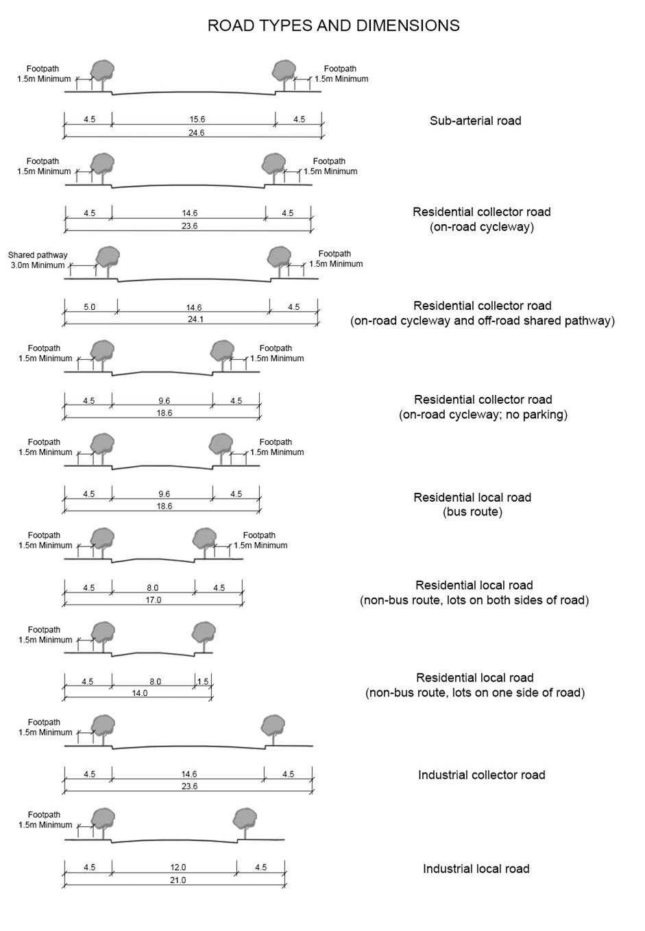 Figure C2.01: Cross sections of road types and dimensions