Section E4 Kotara local character
Kotara local character statement provides an overview of existing and desired future character. The desired future character statement and development controls identify architectural elements of existing dwellings that contribute to the distinct character of the area.
This section applies to residential zoned land in Kotara, referred to as the local character area. Kotara local character area applies to all land within the heavy line in Figure E4.01.
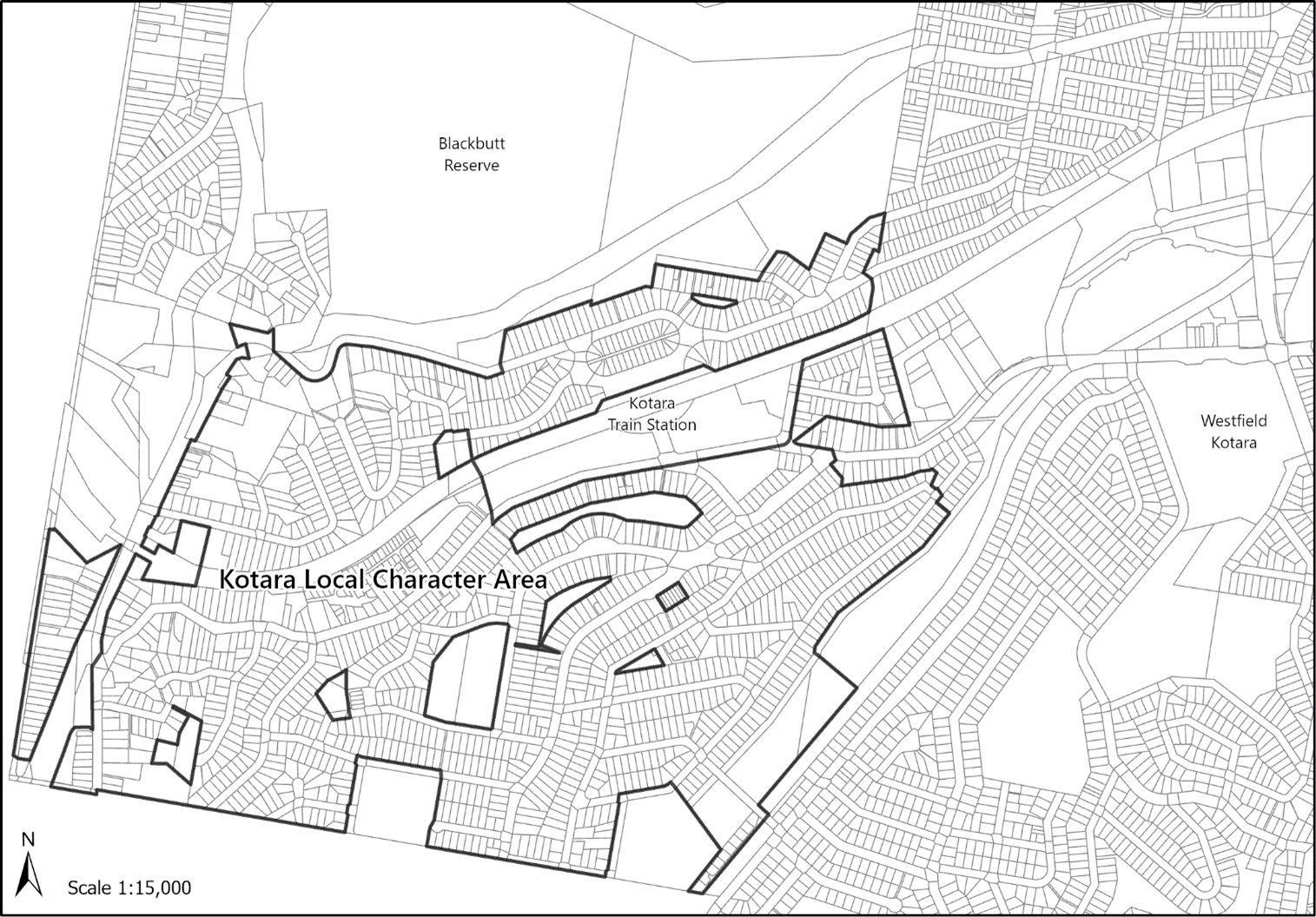 Figure E4.01: Kotara local character area
The following sections will also apply to development:
The following sections may also apply to development:
- Ensure all new development reflects Kotara's existing and future local character.
A word or expression has the same meaning as it has in Newcastle Local Environmental Plan 2012 (LEP 2012), unless otherwise defined.
The subdivision of Kotara was undertaken by the Scottish Australian Mining company in 1925. The subdivision was inspired by the "Garden Suburb" movement which sought to create urban settlements with integrated and accessible transport networks between towns and the central city. The Garden City concept introduced a new way of working in a productive industrial city while being able to enjoy shops, parks, playgrounds and open spaces.
Kotara Estate, comprising the northern and central portions of Kotara was strategically positioned within walking distance to the Great Northern Railway line which would connect future residents to the city centre. The subdivision offered views of the now Blackbutt Reserve to the north and Kotara Park to the south.
While first subdivided in 1925, development in the suburb did not take off until after 1947 when additional housing was required to accommodate the wave of post-war immigration. The subdivision and establishment of Kotara continued well into the mid-1980s and adopted a curvilinear street pattern and long narrow lots in response to the moderate to steep slopes of the area. The continued subdivision of Kotara throughout the twentieth century has resulted in a variety of lot shapes, sizes, housing types and styles. Figure E4.02 below indicates the subdivision dates for the suburb of Kotara.
Interwar and colonial period dwellings are prevalent throughout this area with many dwellings characterised by brick and chamferboard cladding with either corrugated iron or tiled roofs. Many have adopted decorative features such as gable ends, battens, brick piers, awnings and window brackets and recessed verandas. The use of materials, colours and landscaping provides for a varied but consistent streetscape.
Park Forest Estate, subdivided between 1950 and 1980, adopts a significant curvilinear street pattern and long narrow lots consistent with the subdivision pattern of earlier stages. Contemporary style homes reflect traditional housing styles such as veranda piers, detailing and hipped roof forms. Many dwellings display front garages with large setbacks for driveways to the street, due to the increasing popularity of the family car. Manicured front gardens, mature trees, front verandahs are common features between the public and private domain.
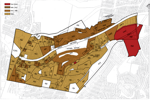 Figure E4.02: Kotara subdivision dates (Source: Coomes Consulting, 05 May 2006)
Kotara is located approximately 9km south west of Newcastle Central Business District (CBD) and offers large residential blocks and dwellings within a bushland setting. Mature trees, undulating streetscapes, generous front setbacks, front gardens and open space are dominant characteristics.
Park Avenue and The Great Northern Railway bisect Kotara creating a northern and southern portion. Park Avenue is the principal traffic carrying road, providing residents with access to the city centre, Westfield Kotara, Kotara Homemaker Centre and Newcastle Inner City Bypass.
Westfield Kotara and Kotara Homemaker Centre feature supermarkets, specialty retail outlets, recreational, entertainment, business, health and medical services providing for the daily and weekly convenience needs of residents and employment. Access is available via Northcott Drive and Park Avenue. Weekend and weekday busy vehicular traffic along Park Avenue is attributed to commuters.
The Great Northern Railway provides an alternate transport option for residents when commuting to Newcastle CBD and neighbouring centres. Whilst convenient for residents to the north of the railway, the railway is not accessible for residents south due to geographical and topographical constraints.
The pocket of Kotara to the north of the railway has views of Blackbutt Reserve. Along local streets, rectangular allotments support low-density residential development comprising predominantly single storey detached dwelling houses that are facebrick or weatherboard construction, with tiled hip roof forms representative of the era in which the subdivision of Kotara first took place. Streets are flanked by managed front gardens that are simple and are either gated or open providing a tidy parkland atmosphere. Large backyards with mature trees preserve the natural backdrop of Blackbutt Reserve.
The pocket of Kotara to the south of the railway is undulating in topography with some areas steeper than others. This area is characterised by a mixture of post-war single storey weatherboard and brick homes with off-street parking to the rear or side of the dwellings. Semi-basement garages are a common feature of dwellings in the area on steeper lots.
Larger front gardens and front building setbacks, stone/brick retaining walls forward of the building and long steep driveways characterise the undulating and steep topography of Kotara.
Alterations and additions to original housing stock, predominately to the rear, occur throughout the area. Infill development represents a range of architectural styles from the twentieth century up to the present day. Kotara has become increasingly popular for medium density infill development due to the large rectangular shaped lots and its proximity to the city centre and services.
Joslin Street and Grayson Avenue are the main thoroughfares from Park Avenue for the southern pocket of Kotara providing residents connections to local streets and landmarks. Landmarks such as Lugar Steet Reserve and Nesbitt Park provide sports facilities, open fields and small playgrounds for the local community. Joslin Street neighbourhood centre provides essential goods and services to the community and has recently undergone beautification.
Distinctive characteristics of the existing character:
- Street frontages are exemplified by a series of detached dwelling houses setback a similar distance from the street with front verandahs, semi-basement parking and generous front gardens.
- Mature trees and open space are located within front and rear yards of dwellings, offering a nice outlook from the street and contribute to the bushland character.
- Architectural styles vary between northern and southern portions of Kotara dependent on the date of subdivision. Interwar and colonial period dwellings with basement and tandem parking arrangements are common housing types.
- Alterations, additions and infill development generally respect the scale of the original house and streetscape by adopting similar styles, colours and materials.
- Lot sizes vary and are dictated by the topography of the area and the time of subdivision. Residential lots long in length are typically on steeper sites and accommodate mature trees in the rear yard.
Kotara's traditional houses, large front gardens and bushland setting are valued by residents and the community. They are distinctive and reflective of when Kotara was first subdivided, the topography of the land and the bushland setting.
The open spaces, parks, front gardens, and mature trees collectively accentuates the bushland setting of Kotara. New development will contribute to the green and leafy suburb of Kotara through a combination of shade trees, shrubs, and greenery. This can be achieved by prioritising the retention of large established trees and minimising hard surfaces.
Generous building separation distances to rear and side boundaries provide for useable outdoor spaces, gardens and comfortable separation from neighbours, and is a key characteristic in Kotara. New development is to adopt the building separation pattern predominant on the street which positively responds to the orientation of the site and surrounding built form.
Off-street parking is to be provided without compromising or dominating the traditional character of the house or street. A tandem or basement parking arrangement preserves the traditional character of dwellings as well as the front garden allowing for the retention and or planting of shade trees and shrubs.
The adaptive reuse of traditional dwelling houses means the internal layout may change, and new space may be required. Alterations and additions are to be sympathetic to the original house and should be relative to the principal dwelling in terms of size, roof form, colour scheme and materials used. Through respectful alterations and additions, traditional dwelling houses can continue to contribute to the character of the suburb and the street.
Distinguishable extensions to the side or forward of the existing dwelling are to be tied into the original house by including elements from the original design or styled in a new way.
Large lots with large frontages are increasingly popular for low rise medium density infill development. Medium density residential development in established residential areas is to be of a height, scale and form consistent with the amenity and character. New development and alterations and additions are appropriately sited and consider solar access, prevailing breezes, setback pattern, the scale of landscaped frontages, natural features and topography to improve the passive performance of the dwelling.
Objectives
- Ensure contemporary development is compatible with the positive characteristics of the existing streetscape or adjoining traditional housing.
- Minimise impacts to existing tree canopy and provide replacement vegetation on the site of similar size and maturity, where existing canopy trees are removed.
- Ensure new development reinforces the natural topography of the site by minimising the extent of site disturbance and the depth of cut and fill.
Controls (C) | Acceptable solutions (AS) | Explanatory notes |
C-1. The built form should not be of a scale that dominates adjoining development or is visually intrusive when viewed from the streetscape. | AS-1. Limit the height and bulk of buildings to ensure they do not overpower adjacent development. AS-2. Utilise similar setbacks and step-back to reduce the visual impact of taller buildings. |
|
C-2. Infill development and alterations and additions opt for a material and colour palette to complement the existing dwelling and the streetscape. | AS-1. Incorporate design elements such as architectural features, building materials, and landscaping that blend seamlessly with the surrounding streetscape. AS-2. Preserve and restore any heritage or traditional elements such as facades, masonry, and other architectural features on existing buildings. |
|
C-3. The design and siting of new development and its ancillary structures, driveways and hard-stand areas are to maximise the retention of vegetation on the site. | AS-1. Where existing vegetation on a site cannot be retained, development replaces canopy trees removed as a result of the development with vegetation of advanced size* and maturity that contributes to the character of the area. | Note: CN might require an applicant to demonstrate why an alternate design incorporating existing vegetation is not achievable as it is not considered appropriate to vary these criteria for economic reasons, such as to achieve a higher density or to enable a “standard design” to fit on the site. *Advanced size and maturity are vegetation of 100L minimum stock size planted in sufficient quantity to achieve a total canopy area of 50% of the removed vegetation when mature. |
C-4. At least 50% of the area forward of the building line is to be dedicated to landscaped area. |
|
|
C-5. Development on slopes is to be stepped in accordance with the maximum cut and fill criteria contained in Section C5 Soil management. |
|
|
| C-6. Development is to provide footpaths for the full width of any site frontage. Where the proposed footpath will adjoin and connect to an existing or approved footpath on an adjoining site, the width of the proposed footpath is to match this footpath width. | AS-1. Maximise opportunities for walking and cycling and where possible, provide bike paths physically separated from traffic. |