Section C12 Open space and landscaping
Landscaping includes all the trees, shrubs, plants, and other vegetation found along our streets, roadways, waterway, parks, and in our gardens, on our balconies, green rooves and vertical green walls.
Vegetation is one of the most important assets. It reduces urban heat and enhances our quality of life by making where people live, work, travel and play more attractive. It also has a role in managing stormwater, providing natural habitat for birds and other wildlife including pollinators and increasing air, water, and soil quality.
This section applies to all development that consists of:
- a new building or structure street tree
- alterations or additions to the external footprint of an existing building or structure
- subdivision of land.
For development involving heritage items or heritage conservation areas identified under Newcastle Local Environmental Plan 2012 (LEP 2012), a merit assessment will be undertaken to ensure the outcomes sought are balanced with heritage conservation outcomes.
The following sections may also apply to development:
- Landscape Technical Manual. The most recent version can be found on the City of Newcastle (CN) website
- Urban Forest Technical Manual. The most recent version can be found on the CN website
- Ensure landscaping is integrated into the design of the development.
- Ensure the character of the development and surrounding landscaping are complementary.
- Improve stormwater quality and reduce stormwater quantity.
- Ensure landscaping does not detract from the local natural environment and provides habitat connections for native plants and animals.
- Improve human wellbeing through the landscape design of private and public space to provide natural spaces, improve residential amenity, reduce urban heat and improve air quality.
- Design open space to improve serviceability, connectivity and access.
- Ensure landscaping is in scale with the built form and complements the built and natural features on the site and adjoining land.
A word or expression has the same meaning as it has in LEP 2012, unless otherwise defined. Other words and expressions include:
- Deep soil zone – is an area of soil within a development unimpeded by buildings or structures above and below ground. Deep soil zones enable planting of vegetation and a permeable ground surface to allow for the infiltration of surface water. They exclude basement car parks, services, swimming pools, tennis courts and impervious surfaces including car parks, driveways and roof areas.
- Environmental land – is land retained onsite for the protection, provision or restoration of the environment; including land avoided under the 'avoid, minimise, offset' hierarchy, and riparian corridors. Environmental land can provide a range of environmental services such as biodiversity protection; values; waterway stability; land stability; flood attenuation; habitat enhancement, biodiversity corridors and buffers; microclimate regulation and climate resilience.
- New residential or industrial site – are identified through land use zoning for future urban development. It has not been developed and is generally located outside the existing urban area.
- Open space – is land that is not developed and is generally free from buildings, structures, roads or car parks. It can be for operational purposes, private, public or communal use and includes passive and active recreational functions.
- Public open space – is an area of open space accessible to the public and intended for outdoor recreation activities and social interaction. Public open space is often owned, managed or maintained by CN or another public authority.
- Street trees – are trees within the road reserve.
For the purpose of this section development proposals are grouped into three categories, which determine the level of information required with a development application (DA):
Category 1 - small scale development with relatively little impact on surrounding development. No landscape plan is required for Category 1 development.
Category 2 - medium scale development with potential visual significance and impact on the amenity of the host neighbourhood.
Category 3 - large scale development or development on prominent or ecologically sensitive sites with a high degree of visual significance and environmental impact.
In general, proposals will be categorised according to the following schedule. CN reserves the right to make a final determination on the development category following consideration of a formal DA.
Schedule of landscape categories for development types
| Development type | Landscape category 1 | Landscape category 2 | Landscape category 3 |
Dwelling houses and secondary dwellings | ✔ | * |
|
Small scale alterations or additions | ✔ | * |
|
Change of use | ✔ | * |
|
Exhibition home | ✔ | * |
|
Dual occupancies, semi-detached dwellings and attached dwellings | ✔ | * |
|
Advertising signs | ✔ | * |
|
Multi-dwelling housing and residential flat buildings |
| 3-10 dwellings | >10 dwellings |
Seniors housing |
| 3-10 dwellings | >10 dwellings |
Industrial development |
| <$2.5M | ≥$2.5M |
Special uses e.g. place of public worship, health services facility or educational establishment |
| <$2.5M | ≥$2.5M |
Commercial development including visitor and tourist facilities |
| < $2.5M | ≥$2.5M |
Subdivision |
| <20 lots | ≥20 lots |
Designated development | Merit | ||
Development in or adjacent to open space or historically, visually or ecologically sensitive sites or natural areas. | Merit | ||
* Some small scale developments may be considered significant because of their nature or where they occur and would fall into Category 2.
| Development category | Application requirements | Explanatory notes |
Category 1 | Landscaping identified on site plan. Plans clearly identify existing and proposed trees, including those proposed for removal. | Show location and dimensions of landscaping and deep soil zones on the site plan including whether on a structure. |
Category 2 | The following landscape documentation:
| Landscape planning documentation is prepared by competent and experienced designers such as:
Specialist advice such as horticulture or Arboriculture should be obtained from members of the Arboriculture Association of Australia, or the Australian Institute of Horticulture with minimum AQF5 qualification. The name and contact telephone number of the author are to be indicated on the required documentation. All required landscape works are implemented by members of the Landscape Association of NSW and/or similar qualified contractors. |
Category 3 | The following landscape documentation:
| All documentation for Category 3 development is prepared by a landscape architect or similar qualified professional practising at the membership level of Registered Landscape Architect of the Australian Institute of Landscape Architects, or as determined. The name and contact telephone number of the author is to be indicated on the required documentation. All required landscape works are implemented by members of the Landscape Contractors Association of NSW and/or similar qualified contractors. |
All categories | Landscape plans are to integrate and be consistent with related plans and reports:
| Related plans and reports are to be prepared and implemented by suitably qualified professions as outlined in the relevant section. |
Subdivisions of more than 50 lots | Visual Impact Assessment to:
| Refer to Guideline for landscape character and visual impact assessment - Environmental impact assessment practice note EIA-N04 (Transport for NSW, 2023). |
Land intended for environmental or conservation purposes | Vegetation Management Plan (VMP) Guidelines and checklists for VMPS are available in the Urban Forest Technical Manual (Appendices). Standard Drawings and specifications for native garden beds and natural area interfaces are available on CN's website (A3000 Series). The VMP is to be prepared by a suitably qualified professional, with a tertiary degree in Natural Resource Management or Environmental Science; or a Diploma in Land Conservation; and a minimum 4 years' experience. |
|
Objectives
- Provide appropriate areas on sites that enables soft landscape and deep soil planting that permits the retention and/or planting of trees and shrubs that will grow to a large or medium size.
- Support protection and enhancement of existing significant landscape features, vegetation and habitat.
- Minimise a proposal's impact on adjoining properties through landscaping.
Ensure consideration is given to the landscape character of the setting.
| Controls (C) | Explanatory notes |
C-1. Landscaping is in scale and context with the proposed development, street reserve width, other buildings, and landscape elements within the streetscape. | For example, it is not appropriate to plant a large tree in the front garden of a small terrace or to landscape a large industrial structure with ground covers. |
C-2. Significant site vegetation and landscape features are incorporated in the landscape areas of a development and linked to local networks for open space and/or environmental lands where possible. |
|
C-3. Adequate provision is made for planted buffer zones between major road and transport corridors and adjoining development as is shown in Figure C12.01 and Figure C12.02. |
|
C-4. Vegetation management for the purposes of bushfire risk management or crime prevention through environmental design is accommodated within the site – not through the clearing, adjustment or management of vegetation on public land. | Vegetation management for private benefit cannot be imposed on adjacent public land. See Planning for Bushfire Protection (NSW Rural Fire Service 2019). |
C-5. The location and design of on-site stormwater management controls and vegetated riparian zones in Figure C12.03 integrate with the design of landscaped plans. |
|
C-6. Deep soil zones are optimised within a site by:
| That basements are completely within the building footprint. Where this is not practical, the extent to which basements protrude from the footprint of the building above should be limited in extent, and their location should not impede the retention of existing vegetation (both within the site and on adjoining properties) and, the provision of new landscaping, including trees of an appropriate scale. |
C-7. Landscape treatment within the front setback is substantial enough to enhance the appearance and integration of the development with the streetscape. |
|
C-8. Landscape design responds to user requirements, considering maintenance, health and wellbeing, aesthetic quality and social and recreational needs. |
|
C-9. Landscape design enhances the amenity and energy efficiency of the development where possible by providing shade to the northerly and westerly elevations of buildings in summer and adequate solar access in winter. |
|
C-10. Landscape areas address privacy issues between the development and adjoining dwellings. |
|
C-11. Plant species selected are suitable for site conditions, using native species where possible, and local indigenous species when adjoining environmentally sensitive sites, such as waterways and bushland. Undesirable species are not selected for planting. | See Urban Forest Technical Manual and Appendix B Landscape Technical Manual. |
C-12. Plant species are selected and located to avoid structures, services and paths. | See Urban Forest Technical Manual and Appendix B Landscape Technical Manual. |
C-13. A vegetated buffer is provided to reduce noise, odour and visual amenity impacts to conflicting sensitive land uses. | Sensitive land uses include, but are not limited to residential development, seniors housing, schools, hospitals, child care facilities, recreation areas, place of worship, community facilities. |
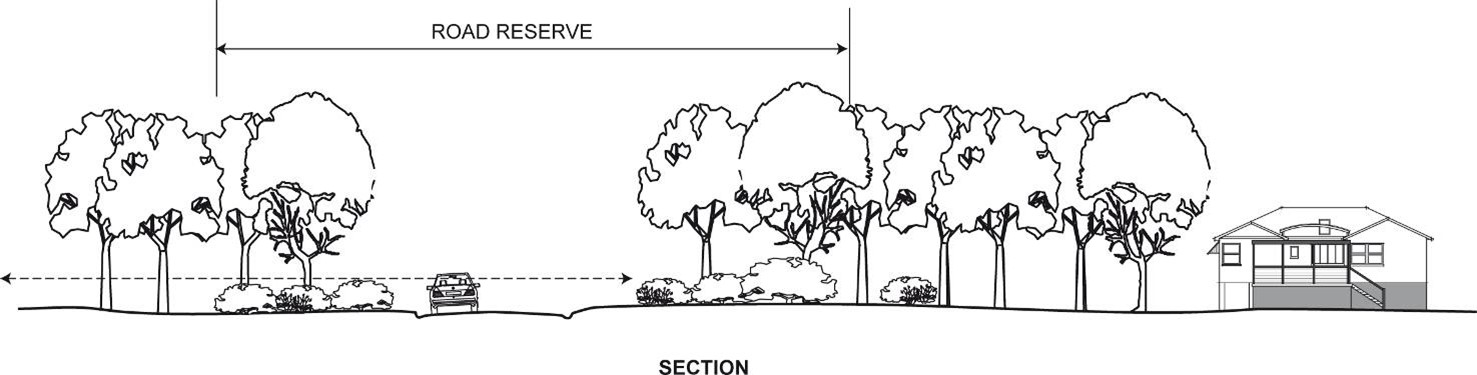 Figure C12.01: Landscape buffer along major road and transport corridors Figure C12.01: Landscape buffer along major road and transport corridors | |
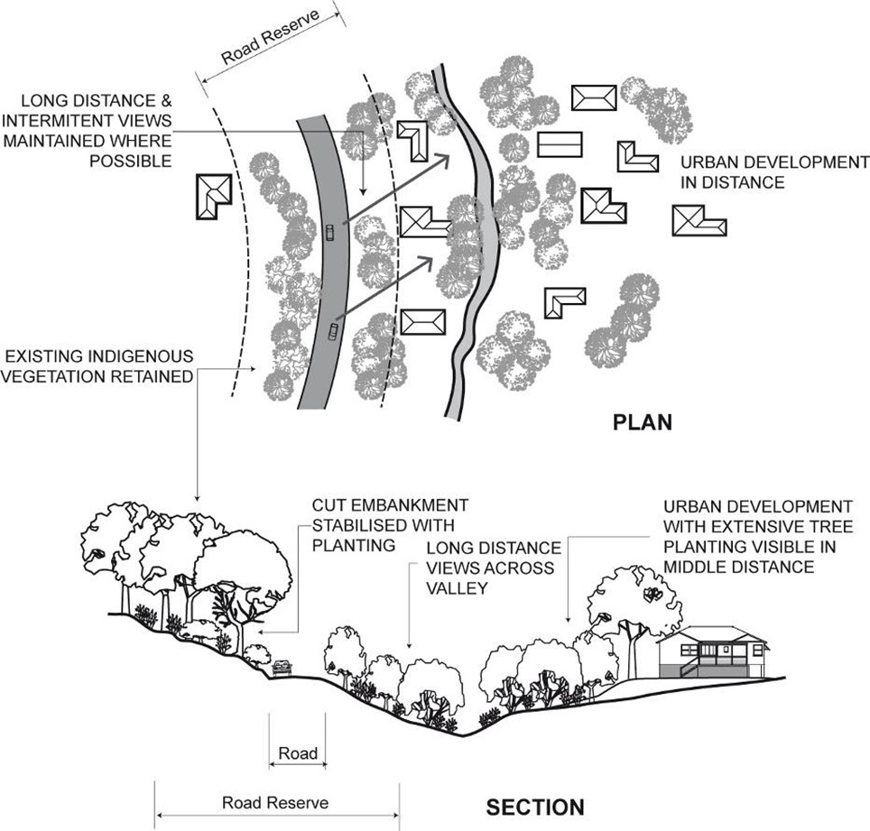 Figure.C12.02: Landscaping between roads and residential development Figure.C12.02: Landscaping between roads and residential development | 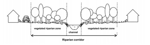 Figure C12.03: Vegetated riparian buffers and corridors. Image care of NSW Department of Planning and Environment, controlled activities – Guidelines for riparian corridors on waterfront land (nsw.gov.au) Figure C12.03: Vegetated riparian buffers and corridors. Image care of NSW Department of Planning and Environment, controlled activities – Guidelines for riparian corridors on waterfront land (nsw.gov.au) |
Objectives
- Ensure subdivision layouts take into account landscaping and site characteristics.
- Ensure significant landscape elements are retained and protected.
- Minimise the impact of development on significant views and vistas.
- Ensure adequate provision of useable public open space for the active and passive recreational needs of residents.
Ensure adequate provision is made for planted buffer zones between major transport corridors, sensitive receivers, and nearby development.
Controls (C) | Explanatory notes |
C-1. All stages of subdivision and development are shown on the landscape plan. | For further information see application requirements. |
C-2. Landscape elements, including native vegetation, wildlife habitats and biodiversity corridors, and vegetated riparian zones are retained, conserved and enhanced. |
|
C-3. Subdivisions are designed so that, when subsequently developed, visually significant vegetation or other natural or built elements are retained. |
|
C-4. Proposals to subdivide visually sensitive or prominent areas address the visual impacts of development in the statement of environmental effects accompanying the application. |
|
C-5. Natural drainage networks and waterways are carefully integrated into landscaped or environmental lands to provide a range of site responsive values while functioning as part of a stormwater drainage system |
|
Objectives
- Ensure significant landscape elements are retained and protected.
- Ensure vehicular and pedestrian circulation is clearly identified and separated.
- Provide open space and environmental lands which:
- is meaningful to place and community
- is multi-functional and adaptable
- provides diversity of recreational experience
- encourages social interaction
- is safe, equitable and accessible
- enhances environmental sustainability
- supports local biodiversity corridors and grids
- is financially sustainable.
Controls (C) | Explanatory notes |
C-1. Open space is included in the landscape plan. | For further information see application requirements. |
C-2. Public open space has frontage to roads, to provide for ease of access, allow for casual surveillance and assist with place making. |
|
C-3. All dwellings within the subdivision are within 400m walking distance of parkland and within a 15 minute drive of a district level facility. |
|
C-4. Land intended as open space takes into consideration:
| CN reserves the right to refuse the dedication of land for open space if it considers it to be unsuitable. |
C-5. Land is generally unsuitable for public open space or environmental lands if:
| CN reserves the right to refuse the dedication of land for public open space if it considers it to be unsuitable. 'Net public benefit’ may involve consideration of financial, economic, environmental, biodiversity, social, health or climate risk and resilience factors. |
C-6. Land intended for environmental or conservation purposes is generally acceptable if it:
|
|
C-7. All new pedestrian and bicycle networks connect into the broader network of proposed and existing pathways. | Refer to Appendix 1of Networks Maps of Newcastle Cycling Plan 2021-2030 for all existing and future cycle paths. |
C-8. Street tree spacing for the subdivision of new residential or industrial sites resulting in new roads: planting at 10 metre intervals is required:
| Requirements for the protection and retention of existing trees, on both public and private property, is covered in section C3 Vegetation preservation and care. |
C-9. Timing for street tree planting for new residential or industrial sites, street trees that comply with C-8a and b (above) may be planted in association with the other subdivision works (i.e., prior to issue of a subdivision certificate for each Stage). Street trees that comply with C-8c (above) are not planted in association with other subdivision work but are to be deferred until 85% of the subsequent developments on the newly created lots have had occupation certificates issued or two years has elapsed from the date of registration of the respective lots, whichever is the latter. | Deferred street tree planting is preference as there is a great loss of new street trees due to builder or driveway construction or vandalism. |
C-10. Bonding street trees in new residential or industrial sites - street trees that comply with C-8 and C-9 (above) (i.e., planted prior to subdivision certificate) will be subject to bonding arrangements. The subdivider is responsible, unconditionally, for any/all tree replacements necessary during the 24 month establishment and maintenance period and a financial security (bond) in an amount equal to 100% of the cost of supply, installation, establishment and maintenance of the trees and associated timber tree guards. |
|
Objectives
- Ensure car parks do not visually dominate the landscape and detract from the local environment.
- Ensure car parks function efficiently and safely while having sufficient shade to reduce heat build-up and glare.
- Ensure significant landscape elements are retained and protected.
Ensure landscaping supports pollinators.
Controls (C) | Explanatory notes |
C-1. Significant landscape elements are conserved and incorporated within the car park design. |
|
C-2. Generous shade trees are planted within the parking area in accordance with the following requirements:
| Crown projection is to be shown on landscape plans. |
C-3. A landscape strip of between 1.5m and 3m is provided along the frontage to a street and/or other public space. |
|
C-4. Canopy trees and different surface treatments, such as permeable paving and the provision of pedestrian access, reduce the visual impact of large parking areas. |
|
C-5. Consideration is given to the following:
|
|
C-6. Clear sightlines are maintained between parking areas, public roads and paths. |
|
C-7. Landscaping does not conflict with lighting services and casual surveillance of parking areas. |
|
C-8. Trees and shrubs are positioned to consider crime prevention through environmental design principles so as not to block sight lines or create areas of concealment. They are to provide adequate sight distance on corners and intersections of roads and paths within the development to avoid safety hazards to motorists and pedestrians. |
|
Objectives
- Improve the amenity of developments and neighbourhoods through quality landscaping.
- Provide suitable areas for landscaped area and deep soil zones.
- Provide consolidated deep soil zones of adequate dimensions to accommodate the retention and/or planting of large and medium size trees.
- Retain the existing natural features of the site that contribute to the neighbourhood character.
Ensure landscaping is climate responsive, supports biodiversity and amenity and reduces urban heat.
Controls (C) | Explanatory notes | |||||||||||||||
C-1. Development has the following minimum landscape and deep soil areas:
| The deep soil zone is measured as a component of the landscaped area. This is to be clearly marked on plans. | |||||||||||||||
C-2. Deep soil zones must have a minimum dimension of 3m. |
| |||||||||||||||
C-3. A landscaped area is provided in addition to private open space. |
| |||||||||||||||
C-4. Landscaped area must:
| 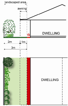 Figure C12.04: Landscaped area and awnings Figure C12.04: Landscaped area and awnings | |||||||||||||||
C-5. A tree with a minimum mature height over 5m is provided per 300m² of the site. | This control applies to any proposal for a single dwelling or ancillary development that will reduce the area of deep soil or landscaped area. | |||||||||||||||
C-6. Deep soil zones retain and accommodate healthy and significant trees on the site and adjoining sites and avoid being located in a trafficable area such as a side boundary that it is primarily taken up by pedestrian routes. | The location of landscaped areas should also reflect the need to retain canopy trees wherever possible and minimise the impact of development on trees on neighbouring sites or the public domain. | |||||||||||||||
C-7. Landscaping includes a combination of tree planting for shade, mid height shrubs, lawn and ground covers. Consider planting deciduous trees for maximum solar access in winter months, and shady, dappled light in summer. | ||||||||||||||||
C-8. Mature trees are to be retained wherever possible. | See Section C3 Vegetation preservation and care for further information about vegetation removal. | |||||||||||||||
C-9. The following ancillary development, and any associated excavation has a setback of at least 3m from the base of the trunk of any declared tree on the lot:
| See section C3 Vegetation preservation and care for further information on the definition of a declared tree. |
Objectives
- Ensure development integrates into established streetscapes and neighbourhoods.
- Ensure landscaped areas are of a useable size and proportions to add value and quality of life for occupants within a development in terms of privacy, outlook, views and recreational opportunities.
- Ensure landscaped areas are sized and located so that the amenity and privacy of adjoining dwellings is maintained.
- Preserve and retain existing established trees.
- Provide consolidated deep soil zones of adequate dimensions to accommodate the retention of established trees and/or planting of large and medium size trees.
- Retain the existing natural features of the site that contribute to the neighbourhood character.
Ensure landscaping is climate responsive, supports biodiversity and amenity and reduces urban heat.
Controls (C) | Explanatory notes | ||||||||||||
C-1. Landscaped and deep soil areas are provided as follows:
The deep soil zone is measured as a component of the landscaped area. | The achievement of minimum landscape area requirements takes precedence over excess site coverage or building to 100% or beyond the applicable maximum building envelope restrictions. | ||||||||||||
C-2. Landscaped area is provided in addition to private open space. |
| ||||||||||||
C-3. Landscaped area must:
|
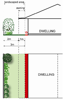 Figure C12.05: Landscaped area and awnings Figure C12.05: Landscaped area and awnings | ||||||||||||
C-4. A minimum 3m wide landscaped area is located along the rear boundary. |
| ||||||||||||
C-5. A minimum 25% of the front setback is landscaped area. |
| ||||||||||||
C-6. Landscaped areas take advantage of existing site conditions and respond to significant site features such as:
|
| ||||||||||||
C-7. Deep soil zones must have a minimum dimension of 3m. |
| ||||||||||||
C-8. Deep soil zones retain and accommodate healthy and significant trees on the site and adjoining sites and avoid being located in a trafficable area such as a side boundary that it is primarily taken up by pedestrian routes. | The location of landscaped areas should also reflect the need to retain canopy trees wherever possible and minimise the impact of development on trees on neighbouring sites or the public domain. | ||||||||||||
C-9. Landscaping includes a combination of tree planting for shade, shrubs, lawn and ground covers. | Crime prevention through environmental design principles for surveillance recommend keeping shrubs low enough to facilitate sightlines and avoid creating concealment spaces. | ||||||||||||
C-10. Mature trees are to be retained wherever possible. | Where trees or native vegetation are proposed to be removed, see section C3 Vegetation preservation and care. | ||||||||||||
C-11. A minimum of one tree with a minimum mature height over 8m is to be provided per 400m² of the site. | |||||||||||||
C-12. Deciduous trees are planted for maximum solar access in winter months, and shady, dappled light in summer. |
|
Objectives
- Improve the visual amenity and urban heat effect of industrial developments using landscape design that relates to the building scale.
- Ensure industrial land uses are adequately screened from residential uses.
- Preserve significant trees and vegetation existing on the site and adjoining sites.
Provide areas on the site that allow for and support healthy plants and trees.
Controls (C) | Explanatory notes | |||||||||||||||
C-1. All setbacks are landscaped where visible from a public place or adjoining or adjacent residential area. |
| |||||||||||||||
C-2. The perimeter of all approved storage areas is landscaped. |
| |||||||||||||||
C-3. In open parking areas at ground level, one shade tree per six spaces is planted within the parking area. | Refer to CN standard drawings A3000 series which can be found of the CN webpage | |||||||||||||||
C-4. All industrial developments meet the following deep soil and canopy cover requirements:
|
| |||||||||||||||
C-5. Deep soil zones retain and accommodate healthy and significant trees on the site and adjoining sites and avoid being located in a trafficable area such as a side boundary that it is primarily taken up by pedestrian routes. |
| |||||||||||||||
C-6. The landscaping responds to:
|
|
Objectives
- Encourage a contribution to healthy biodiversity and the urban forest.
- Improve the microclimate and solar performance within the development.
- Encourage the establishment and healthy growth of grass, trees, soft stem plants and shrubs integrated into the building fabric.
- Ensure that green roofs and walls are integrated into the design of development.
- Encourage well designed landscaping that caters for the needs of residents and workers of a building.
- Design green roofs and walls to maximise their insulating and cooling effects.
Ensure green roofs and walls are designed and maintained to respond to local climatic conditions and ensure sustained plant growth.
Controls (C) | Explanatory notes |
C-1. Planting on structures is designed for optimum conditions for plant growth by:
| For development involving heritage items or heritage conservation areas identified under LEP 2012, a merit assessment will be undertaken to ensure the outcomes sought are balanced with heritage conservation outcomes. Refer to Section E1 Built and Landscape Heritage and Section E2 Heritage conservation areas. |
C-2. Sufficient soil depth and area is provided to allow for plant establishment and growth as per Urban Forest Technical Manual. |
|
C-3. Utilities such as plant rooms, lift overruns or air conditioning units are screened with plantings to improve the aesthetic quality of the development yet allow for ventilation. | Ventilation is essential to plant rooms and air conditioner compressor farms, and cooling. |
C-4. Green roof and wall structures are to be assessed as a part of the structural certification for the building by a suitably qualified engineer. Structures designed to accommodate green walls should be integrated into the building facade including consideration of waterproofing. |
|
C-5. Where vegetation or trees are proposed on the roof or vertical surfaces of any building, a Green Roof or Wall Plan must be submitted. The Plan must demonstrate:
|
|
C-6. Green roofs or walls, where achievable, should use rainwater, stormwater or recycled water for irrigation. |
|
C-7. An instrument of positive covenant to cover proper maintenance and performance of the green roof and walls on terms reasonably acceptable to the CN should be registered prior to granting of the Occupation Certificate. |
|