Section E2 Heritage conservation areas
Schedule 5 in the Newcastle Local Environmental Plan 2012 (LEP 2012) identifies certain areas of townscape and landscape that collectively have special heritage qualities as heritage conservation areas. These areas have a statement of heritage significance and a desired future character statement providing site-specific detail guide any proposed change to buildings, streetscape or landscape features ensuring it complements the heritage conservation area.
A statement of heritage significance identifies the elements which make an item or an area significant in heritage terms. The heritage values can include historical origins, subdivision patterns, and consistency of building materials or the common age of its building stock. These statements are prepared using the NSW Office of Environment and Heritage criteria, outlined in the NSW Heritage Manual, and based on principles and processes of the Burra Charter.
The desired future character statement is a summary of the existing urban fabric and key character elements of a heritage conservation area which are to be preserved to guide how future development may achieve contextual fit and enhance the existing qualities of each area.
Development on land within or in vicinity of a heritage conservation area is to be designed based on site-specific detail in this section and in conjunction with Section E1 Built and Landscape Heritage.
This section applies to all development on land identified as heritage conservation area on the heritage map of LEP 2012 and described in Schedule 5.
The following sections will also apply to development:
The following sections may also apply to development:
- Establish characteristics to be preserved and/or sensitively restored or reconstructed for the heritage conservation areas respectively.
- Protect/maintain heritage significance of the heritage conservation areas.
- Ensure development is designed sympathetically to the heritage significance and desired future character of the heritage conservation area.
A word or expression has the same meaning as it has in LEP 2012, unless otherwise defined.
This section applies to land within Cameron's Hill Heritage Conservation Area as listed in Schedule 5 and mapped in LEP 2012- Heritage Map (HER_004C).
It maps the area for controls provided in Section E1 Built and landscape heritage and is to be read with that section and the heritage significance and desired future character statements of this section, to understand the heritage requirements.
 Map E2.01: Land application - Cameron's Hill Heritage Conservation Area
Key period of significance – circa 1840 to 1940
Cameron's Hill has historical significance for its association with the early decades of the AACo. The area demonstrates the early days of nongovernment coal mining in the local area and represents the founding of Hamilton. Its earliest settlement was an assortment of mine workings, primitive slab huts and lean-tos, a few brick houses, and a brickyard, clustered around the AACo's 'D' Pit. This influenced the emerging townships on the surrounding flat land. Following the closure of the mine, the area gradually transitioned into a residential suburb, closely influenced by the decisions and activities of the AACo. The study area is a notable example of patterns of domestic life in the local area, illustrating the transition from its origins as an industrial mining area to a residential area for the more affluent social classes. This contrasts to development that occurred on the surrounding flat and flood prone land, formerly known as Happy Flat and Pit Town. This provides a demonstration of social hierarchies and living standards in the nineteenth and twentieth centuries.
Cameron's Hill has strong associations with the Colliery Department of the Australian Agricultural Company and its senior staff, whose influence defined the development of Hamilton and surrounds.
The area has aesthetic significance at a local level, demonstrating characteristics that define the late Victorian and Federation periods in Australian urban development, with early buildings and the street layout closely influenced by the development of the AACo's mining operations. Surviving buildings from the mid to late nineteenth century provide evidence of this period of mining operations. The elevated position and subdivision following the closure of the 'D' Pit resulted in the proliferation of grander residences in the early twentieth century.
Cameron's Hill is a significant representative example of a Federation period residential subdivision in the Newcastle area. It retains a substantial proportion of original dwellings, forming cohesive and attractive streetscapes with an established sense of place. The area demonstrates a range of characteristics associated with this time. It is highly intact, being developed in a relatively condensed period. The area is strongly characterised by intact streetscapes and contributory dwellings including particularly fine examples of the Federation Arts and Crafts style.
The character of the Cameron's Hill Heritage Conservation Area is made up of a variety of building styles and settlement patterns dating from the late 19th century and early decades of the 20th century. The special character of Cameron's Hill is to be preserved, celebrated and maintained through the retention of contributory buildings, street trees, existing subdivision pattern and elements of visual interest and heritage significance.
Elements to preserve and/or sensitively restore or reconstruct (based on evidence of original appearance) include:
- A range of contributory and historic buildings built before the Second World War, particularly intact or historically significant groupings, heritage items, iconic structures, and the appearance and layout of streets.
- Single storey scale of housing stock, with a small number of two-storey residences in elevated positions, that is an original defining feature of the area.
- An existing subdivision pattern and street layout, including preserving the human scale of development, the fine grain and the groupings of intact Federation era weatherboard and brick cottages and bungalows, as well as larger villa residences, which have high contributory value to the streetscape.
- Contributory dwellings that retain ornate timber details demonstrative of the Arts and Crafts movement.
- Dwellings that display a good degree of integrity and intactness, incorporating typical details such as verandahs, corrugated metal and terracotta tile roofs, timber barge boards and joinery, finials, decorative chimneys, and coloured glass windows.
- Mature trees in gardens and the public domain.
- Public open space including the Hamilton Rotary Park.
- Heritage picket and brick fences.
- Exposed face brick and stone of existing building facades and front fencing.
- A traditional road layout and street furniture such as sandstone kerbing and guttering, brick paving, and other features of historical interest.
- Items of heritage significance individually listed as heritage items in Schedule 5 of LEP 2012, including retention of the three-dimensional form and adaptive re-use of heritage item buildings.
The following images demonstrate the characteristic features of the Cameron's Hill Heritage Conservation Area.
 Figure E2.01: St Peters Anglican Church, one of the many heritage items in Cameron's Hill contributing significantly to the streetscape. |
 Figure E2.02: Typical group of Federation era brick cottages maintaining consistent urban form with design elements resulting in a harmonious streetscape. |
 Figure E2.03: Single storey scale of housing stock with different architectural styles from mid-19th and early 20th centuries contributing to distinct visual character in Cameron's Hill. |
 Figure E2.04: Small number of two-storey villa residences in elevated positions. |
 Figure E2.05: Dwellings that retain ornate timber details demonstrative of the Arts and Crafts movement. |
 Figure E2.06: Typical streetscape consisting of a single storey building built between mid-19th and early 20th century, mature trees in gardens within public domain. |
This section applies to land within Cooks Hill Heritage Conservation Area as listed in Schedule 5 and mapped in LEP 2012- Heritage Map (HER_004G).
It maps the area for controls provided in Section E1 Built and landscape heritage and is to be read with that section and the heritage significance and desired future character statements of this section, to understand the heritage requirements.
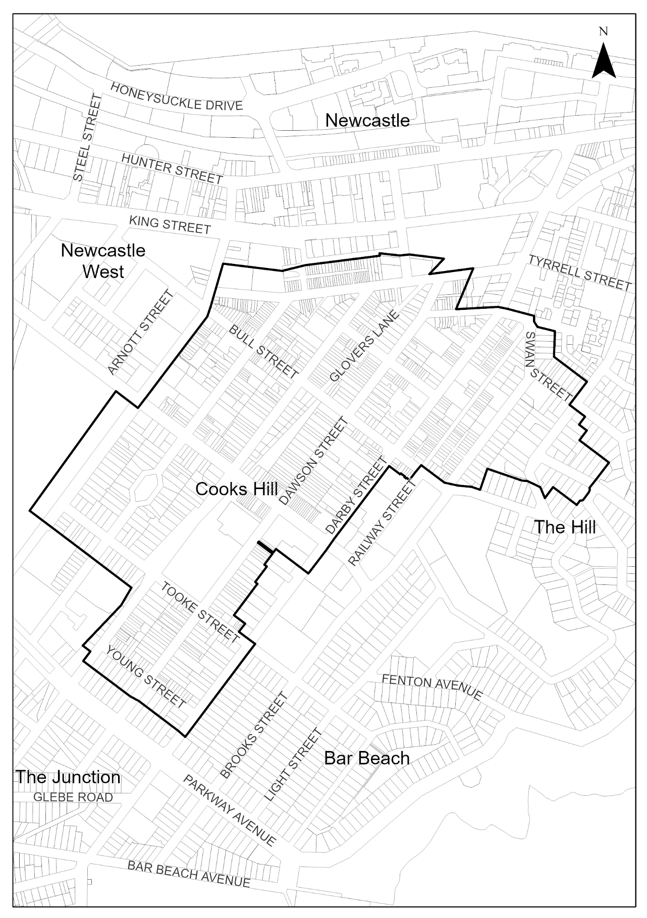 Map E2.02: Land application – Cooks Hill Heritage Conservation Area
Key period of significance – circa 1850 to 1940
Cooks Hill Heritage Conservation Area is culturally significant on a number of levels. As a residential and commercial precinct, it is regarded for its special historical character, liveable streetscapes, diverse range of historic residential and commercial buildings and tree lined streets. The age of the suburb, relative to other suburbs of the Newcastle local government area (LGA), is apparent in the style and form of buildings and eclectic street layout.
It has a significant visual character comprising buildings which represent all of the common architectural styles including mid-19th century workers' houses and terraces, federation bungalows, inter-war cottages and post-war residential flat buildings. A critical mass of contributory buildings, traditional streetscapes, significant trees, sandstone kerb and gutters, artefacts, heritage listed hotels, shops and parklands create a strong sense of place and a distinctive historic identity valued by local residents and visitors.
Cooks Hill is closely associated with the Australian Agricultural Company (AAC) as part of the original 2000-acre grant owned by the company. The AAC began to sell off parts of Cooks Hill in the 1850s. However, even before that the AAC built huts for its workmen and so the area began its life as a mining village. When the first land sales occurred, development was rapid along Lake Macquarie Road (Darby Street) and eventually Blane Street (Hunter Street), becoming an extension of the main streets connected to the city centre.
The early houses were single and two storey terraces and miners' cottages, both brick and timber. Retailing and hotels flourished as did the population. The area is significant as it reflects land uses and activities of the AAC. Its mines, railways, and the Colliery railway serving Merewether district, exercise a strong physical presence over Cooks Hill.
The character of the Cooks Hill Heritage Conservation Area is made up of a variety of building styles and settlement patterns dating from late 19th and early decades of the 20th century. The special character of Cooks Hill is to be preserved, celebrated and maintained through the retention of contributory buildings, street trees, existing subdivision pattern and elements of visual interest and heritage significance. The eclectic character of Cooks Hill is to provide residents with a unique and valued sense of place.
Elements to preserve and/or sensitively restore or reconstruct (based on evidence of original appearance) include:
- Contributory buildings constructed prior to the Second World War.
- Mature trees in gardens and public domain.
- Former Burwood Coal and Copper Company rail line and bridge abutments at Laman Street.
- Heritage fences.
- Exposed face brick and stone of existing building facades and front fencing.
- Sandstone kerbing and guttering.
- Victorian era post box on Corlette Street and horse trough at corner of Young and Darby streets.
- Single or two storey scale of housing stock that is an original defining feature of the residential streets.
- Two-storey scale of buildings with parapets concealing roofs from the street and mansard roofs, and the mix of shop top housing and commercial premises that is an original defining feature of Darby Street and the street block addressing Union Street between Bull and Laman streets.
- Dense rhythmic arrangement of small bay widths along the building facades of Darby, Union, Bull, Laman, Gibbs, Queen, Corlette, Bruce, Young, Council, and Railway streets.
- Cantilevered awnings and balconies and single or two storey verandahs (often with cast iron columns, balustrades and decorative lacework) over the footpath of Darby, Union and Bull Streets, and where they occur on other streets in the heritage conservation area.
- Reinforce a consistent street edge alignment for properties along Darby Street.
- Pubs and shops on Darby, Union and Bull Streets.
- Public parks, including Centennial Park, Corlette Street and National Park.
- Items of heritage significance individually listed as heritage items in Schedule 5 of LEP 2012, including retention of the three-dimensional form and adaptive re-use of heritage item buildings.
- Rich record of relics and archaeological sites beneath the modern city.
The following images demonstrate the characteristic features of the Cooks Hill Heritage Conservation Area.
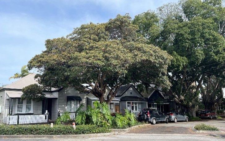 Figure E2.07: Street lined with mature trees alongside single-storey workers cottages contributing significantly to the streetscape. Figure E2.07: Street lined with mature trees alongside single-storey workers cottages contributing significantly to the streetscape. |
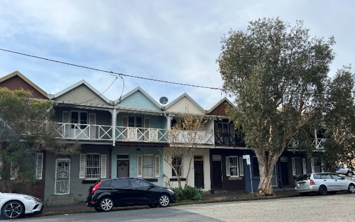 Figure E2.08: Typical group of buildings maintaining consistent urban form with design elements resulting in a harmonious streetscape. Figure E2.08: Typical group of buildings maintaining consistent urban form with design elements resulting in a harmonious streetscape. |
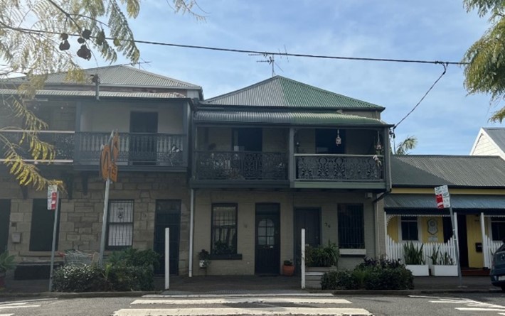 Figure E2.09: Mix of single and two-storey buildings with different architectural styles from mid-19th and early 20th centuries contributing to distinct visual character in Cooks Hill. Figure E2.09: Mix of single and two-storey buildings with different architectural styles from mid-19th and early 20th centuries contributing to distinct visual character in Cooks Hill. |
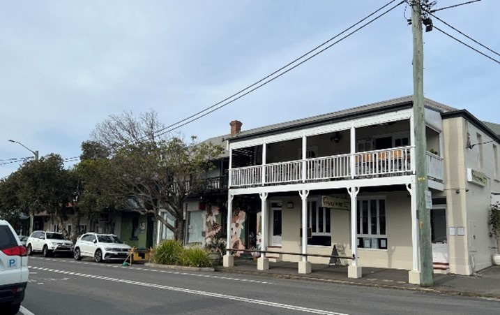 Figure E2.10: Cantilevered balconies with ornate elements over footpath in high street/commercial premises. Figure E2.10: Cantilevered balconies with ornate elements over footpath in high street/commercial premises. |
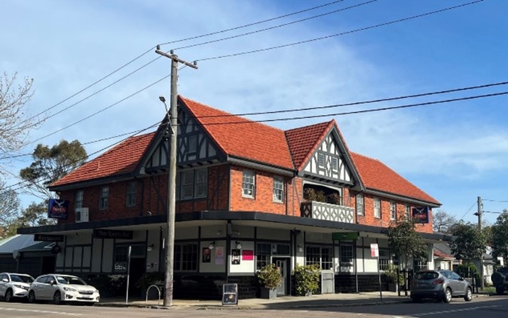 Figure E2.11: Heritage building with commercial use. Figure E2.11: Heritage building with commercial use. |
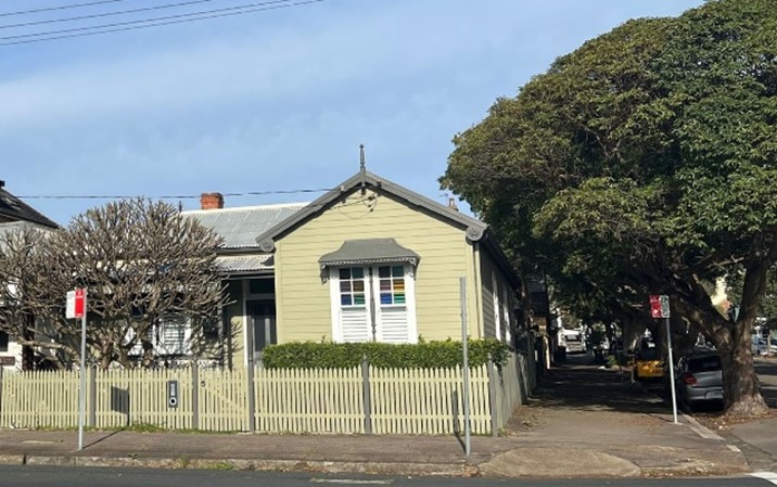 Figure E2.12: Typical streetscape consisting of a single storey building built between mid-19th and early 20th century, sandstone kerb, mature trees in gardens within public domain. Figure E2.12: Typical streetscape consisting of a single storey building built between mid-19th and early 20th century, sandstone kerb, mature trees in gardens within public domain. |
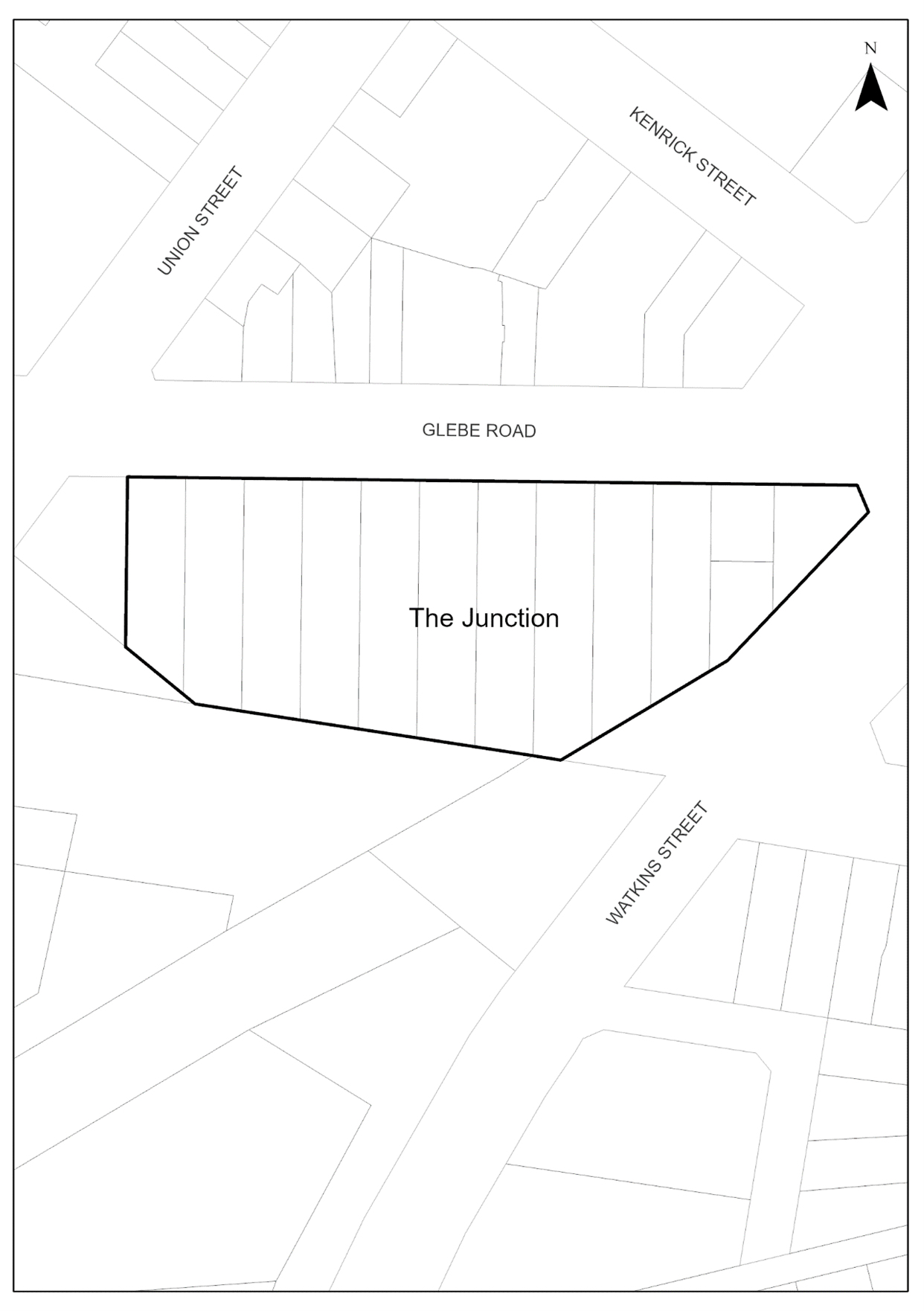
This section applies to land within Glebe Road Federation Cottages Heritage Conservation Area as listed in Schedule 5 and mapped in LEP 2012- Heritage Maps (HER_004G). The heritage conservation area is located on the southern side of Glebe Road, between the intersections of Watkins Street and Union Street, The Junction.
It maps the area for controls provided in Section E1 Built and landscape heritage, and is to be read with that section and the heritage significance and desired future character statements of this section, to understand the heritage requirements.
 Map E2.03: Land application – Glebe Road Federation Cottages Heritage Conservation Area
Key period of significance - circa 1909 – 1915
The Glebe Road Federation Cottages Heritage Conservation Area is important at the local level as it demonstrates the principal characteristics of the Federation period and nature of residential building construction between 1909 and 1915. The narrow window of time in which the precinct developed is significant in providing evidence of the key features of the federation period including construction and building technologies, fashion and key elements of style. Those being the single storey scale of these modest detached row of dwellings, symmetrical street frontage set close to Glebe Road and set off side boundaries, open verandah, pyramidal roof form, hip and gable roofs, bearer and joist construction with lightweight cladding material (weatherboard), and absence of garaging with parking occurring at the rear accessed via side driveways. The uniformity of the group in terms of architectural style, age, height, form, massing, setbacks, materials, and lack of obvious garaging contributes to defining the character.
The house at 55 Glebe Road has associative significance with a prominent individual, being the home of RJ Kilgour, a past Mayor of Merewether, and whose son was the first to enlist locally in 1915 for the First World War. The group of houses itself has associational significance with the AAC, and the south east boundary line abuts the easement of the former Burwood coal and copper company railway line, which was the Merewether estate's coal haulage line.
The character of the Glebe Road Federation Cottages Heritage Conservation Area is made up of single storey Federation cottages built between 1909 - 1915. The homogenous character of this precinct is to be preserved, celebrated and maintained through the retention of all contributory buildings, existing subdivision pattern and elements of visual interest and heritage significance.
Elements to preserve and/or sensitively restore or reconstruct (based on evidence of original appearance) include:
- Building group at 55 to 75 Glebe Road, The Junction, is a fine representative of a group of intact federation era cottages which have high contributory value to the streetscape.
- Single storey scale of housing stock that is an original defining feature of federation cottages group.
- Exposed face brick of existing building facades and front fencing.
- Consistent height of front fencing, constructed of timber or brick.
- Consistent front and side setbacks including retaining the offsets to the eastern side boundaries and keeping front gardens as open space.
- Urban form reflects a regular pattern of subdivision and development dates from the 1900 - 1920.
- Main entry to houses in front verandah facing the street, with connection via front garden footpath.
- Mature trees in gardens and relationship of houses to their gardens and to each other.
- Side driveways with access to garages and on-site car parking accommodation at the rear of the house group.
- Items of heritage significance recommended for individual listing as heritage items in Schedule 5 of LEP 2012.
The following images demonstrate characteristic features of Glebe Road Federation Heritage Conservation Area.
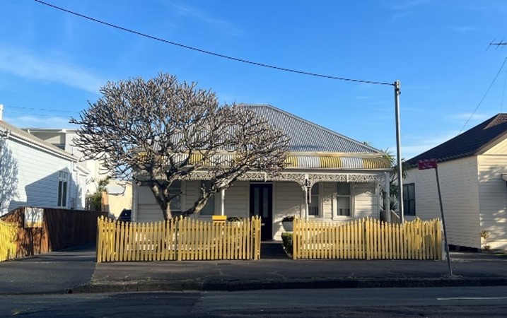 Figure E2.13: Federation cottage exhibiting key characteristics of federation style. Figure E2.13: Federation cottage exhibiting key characteristics of federation style. |
 Figure E2.14: Array of federation cottages featuring the single-storey scale, uniform subdivision pattern, consistent street scape with front gardens, timber fence, and side driveways. Figure E2.14: Array of federation cottages featuring the single-storey scale, uniform subdivision pattern, consistent street scape with front gardens, timber fence, and side driveways. |
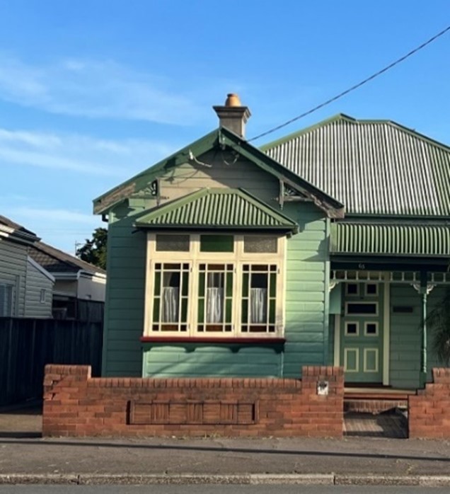 Figure E2.15: Federation cottage exhibits original design elements of federation style. Figure E2.15: Federation cottage exhibits original design elements of federation style. |
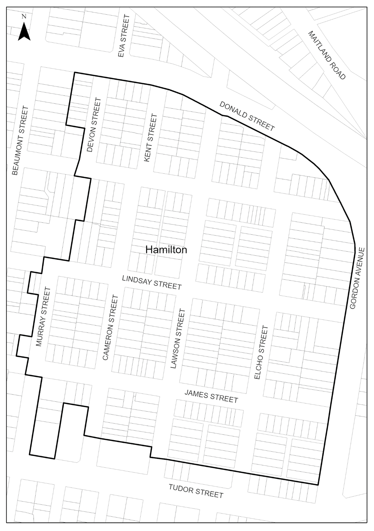
This section applies to land within the Hamilton Business Centre Heritage Conservation Area as listed in Schedule 5 and mapped in LEP 2012- Heritage Maps (HER_004B, HER_004C, HER_004G, and HER_004FA). The heritage conservation area is in Hamilton located between Hudson Street to the north, Murray Street to the east, Denison Street to the south, and William Street and Bennett Street to the west.
It maps the area for controls provided in Section E1: Built and landscape heritage, and is to be read with that section and the heritage significance and desired future character statements of this section, to understand the heritage requirements.
 Map E2.04: Land application – Hamilton Business Centre Heritage Conservation Area
Key period of significance – circa 1870 to 1940
Hamilton Business Centre Heritage Conservation Area is of heritage significance for its role in economic and social life of the local Hamilton community. It contains many examples of two storey shops and commercial premises that reflect various periods of economic growth and social history.
The area represents waves of immigration during the 20th century and eastern European immigrants who established businesses in the street. The earliest examples of Italian and Greek eateries opened on Beaumont Street during the 1950s. The Newcastle Earthquake of 28 December 1989 dramatically changed Beaumont Street. There was widespread damage, loss of life and major social dislocation. The buildings that survived were revitalised and many of two storey shopfronts were saved by judicious planning and urban design.
Beaumont Street is a thriving urban centre with cosmopolitan character. Two storey scale defines the character of the street. Unfortunately, many buildings have been compromised by unsympathetic signage.
The character of Hamilton Business Centre Heritage Conservation Area is made up of a variety of building styles and settlement patterns that date from the late 19th and early decades of the 20th century. The special character of Hamilton business centre is to be preserved, celebrated and maintained through retention of contributory buildings, two storey scale commercial buildings, existing subdivision pattern and elements of visual interest and heritage significance.
The commercial and cosmopolitan character of Hamilton Business Centre is to continue to provide visitors, residents and commercial businesses with a unique and valued sense of place.
Elements to preserve and/or sensitively restore or reconstruct (based on evidence of original appearance) include:
- Contributory buildings constructed prior to the Second World War.
- Two-storey scale of buildings with mix of shop top housing and commercial premises built to the boundary alignment that is an original defining feature of Beaumont Street.
- Exposed face brick and stone of existing building facades and front fencing.
- Active street frontages in commercial buildings at the ground floor level.
- Dense rhythmic arrangement of common bay widths and first floor windows (often in the form of French doors) of building facades with vertical proportions and glass-solid on facade of less than 1:1.
- Cantilevered awnings and single or two storey verandahs (often with cast iron columns, balustrades and decorative lacework) over the footpath on Beaumont Street.
- Parapets concealing roofs from the street.
- Masonry buildings with face brick or rendered wall surfaces.
- Sandstone kerbing and guttering.
- Side streets off Beaumont Street being predominantly residential in character and of single storey scale, typified by detached dwellings.
- Items of heritage significance individually listed as heritage items in Schedule 5 of LEP 2012, including retention of the three-dimensional form and adaptive re-use of heritage item buildings.
The following images demonstrates the characteristic features of the Hamilton Business Centre Heritage Conservation Area.
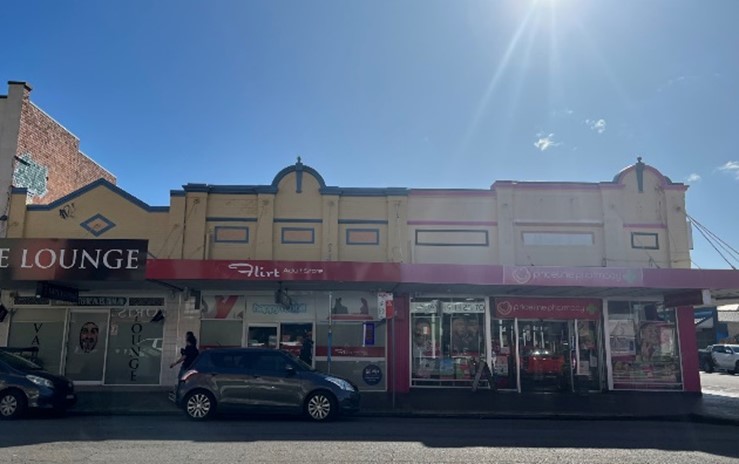 Figure E2.16: Commercial buildings with active frontages and parapet wall concealing the roofs. Figure E2.16: Commercial buildings with active frontages and parapet wall concealing the roofs. | 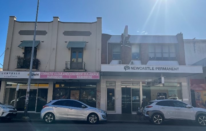 Figure E2.17: Two-storey buildings with mix of shop top housing and commercial premises built to boundary. Figure E2.17: Two-storey buildings with mix of shop top housing and commercial premises built to boundary. |
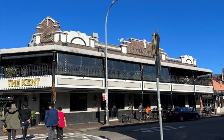 Figure E2.18: Contributory building constructed prior to second world war with cantilevered cast iron balconies adorned with decorative lacework over the footpath on Beaumont Street. Figure E2.18: Contributory building constructed prior to second world war with cantilevered cast iron balconies adorned with decorative lacework over the footpath on Beaumont Street. | 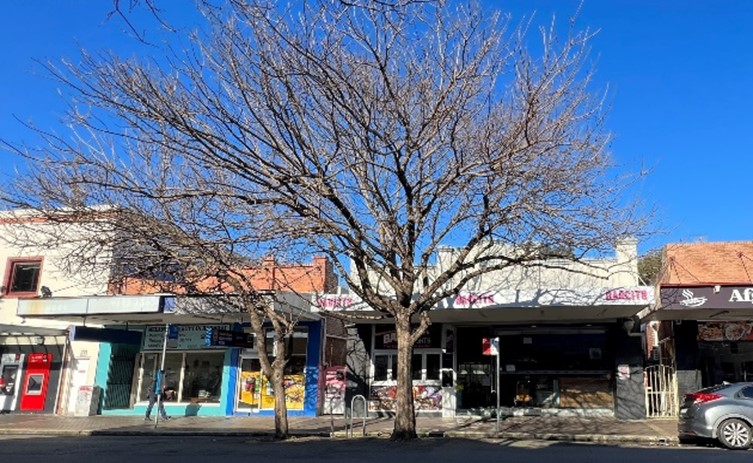 Figure E2.19: Mix of single and two-storey buildings consisting of uniform subdivision pattern, active frontages with sandstone kerbing and trees present in public domain. Figure E2.19: Mix of single and two-storey buildings consisting of uniform subdivision pattern, active frontages with sandstone kerbing and trees present in public domain. |
This section applies to land within Hamilton Residential Precinct Heritage Conservation Area as listed in Schedule 5 and mapped in LEP 2012- Heritage Maps (HER_004FA and HER_004G). The heritage conservation area is in Hamilton located between Donald Street to the north, Gordon Avenue to the east, Tudor Street to the south, and Murray Street and Devon Street to the west.
It maps the area for controls provided in Section E1: Built and landscape heritage, and it to be read with that section and the heritage significance and desired future character statements of this section, to understand the heritage requirements.
 Map E2.05: Land application – Hamilton Residential Precinct Heritage Conservation Area
Key period of significance – circa 1870 to 1940
The Hamilton Residential Precinct Heritage Conservation Area is a low scale, residential area typified by small lot housing generally one or two storeys, built close to boundaries, and located towards the front of the block. The character of the area and its streetscapes is representative of late Victorian, Federation and inter-war periods of Australian urban development. The style of housing - late Victorian terraces and cottages, Federation cottages and bungalows in the popular styles of the time, Italianate, Queen Anne, Edwardian, and California and Spanish Mission influences. In particular, a large number of detached terrace houses comprising small lot housing, traditional street grid nestled adjacent to Hamilton railway station with general absence of space for vehicle accommodation.
The Hamilton residential precinct represents a pattern of urban settlement that represents gradual urban infill of the Newcastle coal field as mining moved out to the Hunter valley from 1880s until the turn of the 20th century. Urban development in the suburb reflects the gradual release of land by the AAC, with some houses built as early as 1870. Most of the suburb was released in 1885 -1886, and 1900 -1920. Hamilton’s development between 1880 and 1900 reflects a period of intensive infrastructure investment by the state government, comprising the opening of the railway and train station in 1887. This attracted people to the suburb from the city centre and the style and age of much of the housing stocks reflects this period. The Hamilton Residential Precinct Heritage Conservation Area has special associations with the AAC, being part of their 2000 acre grant of land in inner Newcastle. The township developed around the lucrative borehole pit, and was named 'Pit Town', with operations at the No 1 pit, No 2 pit, the Hamilton pit and the lucrative D pit on Cameron's Hill, all of which were opened up in the late 1840s and 1850s. The enduring legacy of the AAC is reflected in the contemporary names of streets, including Lindsay, Denison, Cleary, Everton and Skelton Streets. The smaller lot layout of the residential area of Hamilton can be attributed to the manner in which the AAC released land for sale, the main purchasers being miners and company employees, and also an era of urban development before the widespread use of the motor car, with little space made for car parking.
The character of the Hamilton Residential Precinct Heritage Conservation Area consists of a variety of building styles and settlement patterns that date from the late 19th and early decades of the 20th century. The special character of Hamilton residential precinct is to be preserved, celebrated and maintained through the retention of contributory buildings, street trees and elements of visual interest and heritage significance.
Elements to preserve and/or sensitively restore or reconstruct (based on evidence of original appearance) include:
- Range of contributory and historic buildings, particularly intact or historically significant groupings, heritage items, iconic structures, and the appearance and layout of streets.
- Single or two storey scale of housing stock that is an original defining feature of the precinct.
- Exposed face brick and stone of existing building facades and front fencing.
- Many houses located towards the front of the block with small and low-fenced front yards, and some others built to the street without front yards.
- Traditional road layout and street furniture such as sandstone kerbing and guttering, and other features of historical interest.
- Urban form which reflects a regular pattern of subdivision and development that dates from the 1890s to the 1930s and building stock from this period.
- Mature trees in gardens and the public domain.
- Prevailing absence of garages and on-site car parking accommodation.
- Items of heritage significance individually listed as heritage items in Schedule 5 of LEP 2012, including retention of the three-dimensional form and adaptive re-use of heritage item buildings.
The following images demonstrates the characteristic features of the Hamilton Residential Precinct Heritage Conservation Area.
 Figure E2.20: Mix of single and two storey building stock present in the area. Figure E2.20: Mix of single and two storey building stock present in the area. |
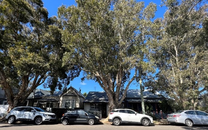 Figure E2.21: Streetscape with a variety of building styles, low scale, settlement pattern from the late 19th to the early 20th centuries with mature trees in public domain. Figure E2.21: Streetscape with a variety of building styles, low scale, settlement pattern from the late 19th to the early 20th centuries with mature trees in public domain. |
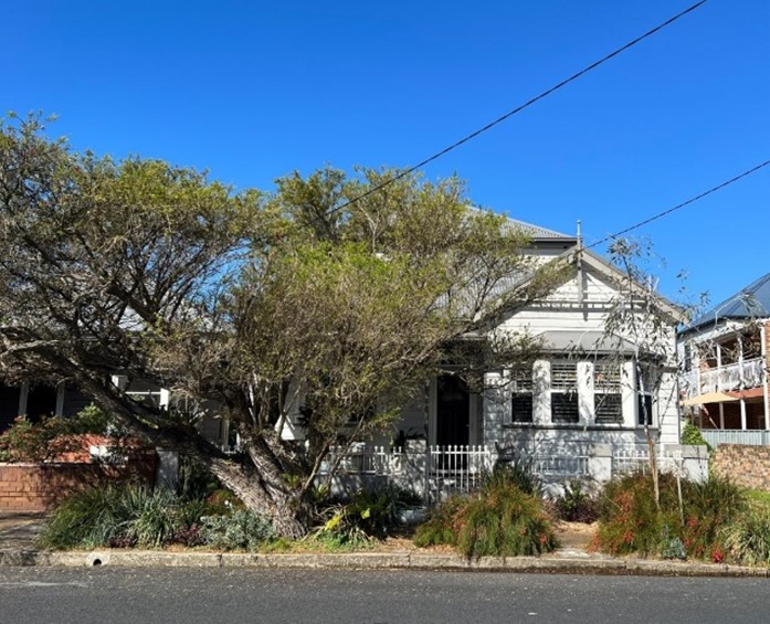 Figure E2.22: Cottage with original ornate elements, mature trees in the public domain with sandstone kerbing contributing to historic character. Figure E2.22: Cottage with original ornate elements, mature trees in the public domain with sandstone kerbing contributing to historic character. |
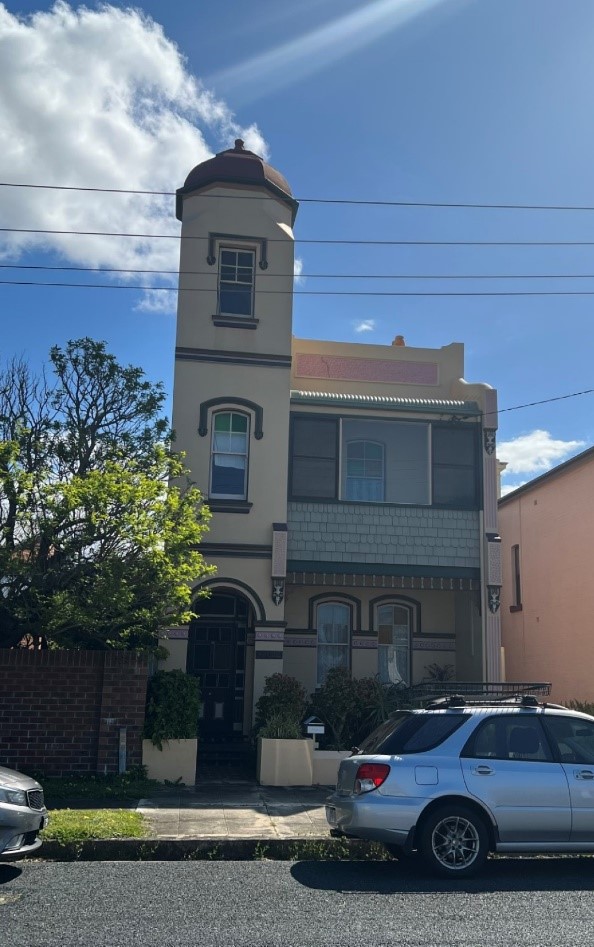 Figure E2.23: Detached two storey house with unusual tower feature contributing to character. Figure E2.23: Detached two storey house with unusual tower feature contributing to character. |
This section applies to land within the Hamilton South 'Garden Suburb' Heritage Conservation Area as listed in Schedule 5 and mapped in LEP 2012- Heritage Maps (HER_004G). The heritage conservation area is in Hamilton East, Hamilton South and Merewether located between Denison Street, Everton Street and Warrah Street to the north, National Park Street, Jenner Parade and Smith Street to the east, Glebe Road to the south, and Gordon Avenue to the west.
It maps the area for controls provided in Section E1 Built and landscape heritage, and is to be read with that section and the heritage significance and desired future character statements of this section, to understand the heritage requirements.
 Map E2.06: Land application – Hamilton South 'Garden Suburb' Heritage Conservation Area
Key period of significance – circa 1913 to 1940
Hamilton South 'Garden Suburb' Heritage Conservation Area is significant to the local community with surviving evidence of an early 20th century subdivision pattern associated with the AAC, and made up of single dwellings on large 'suburban' style allotments generally over 600 square metres. The character of the area and its streetscapes is representative of Federation and inter-war periods of Australian urban development. The style of housing - early 20th century Federation and Inter-war cottages and bungalows in the popular styles of the time, Italianate, Queen Anne, Edwardian, and California and Spanish Mission influences. In particular, a large number of detached houses consistently and generously setback from the street in landscaped front gardens, with side driveways and vehicle accommodation located at the side or rear of the dwelling.
The precinct has associational significance with the eminent Australian architect and planner Sir John Sulman and as such its original form is important evidence of his work and ideas. The suburb is one of the earliest and largest examples of a planned garden suburb and as such is historically important. The evidence of Sulman’s original design is reflected in the road layout, allotment shape and pattern, and form of housing – single storey detached bungalow and cottage style houses, with a consistent palette of face brick and painted weatherboard houses.
The houses at 154 Gordon Street and 141 Gordan Avenue are significant to the suburb as they were used as "display" homes by the AAC to sell its Garden Suburb idea. Designed by notable architect F.G. Castleden, they were built to coincide with the release of the AAC's Hamilton estate, in 1914.
The character of the Hamilton South 'Garden Suburb' Heritage Conservation Area is made up of a variety of building styles that date from the late 19th and early decades of the 20th century. The special character of Hamilton South 'Garden Suburb' is to be preserved and maintained through the retention of contributory buildings, open space, existing subdivision pattern and maintenance of the 'Garden Suburb' layout, street trees and elements of visual interest and heritage significance such as Parkway Avenue, Learmonth Park, small pocket parks, and the vegetated edges of Cottage Creek.
Elements to preserve and/or sensitively restore or reconstruct (based on evidence of original appearance) include:
- Original dwellings of the 'Garden Suburb' which were built up to 1935.
- Single storey scale of housing stock that is an original defining feature of the 'Garden Suburb'.
- Exposed face brick and stone of existing building facades and front fencing.
- Consistent front and side setbacks including retaining the offsets to side boundaries and keeping front gardens as open space.
- Side driveways with new garages located at the rear of the dwelling, and new carports located at the back or at the side of the dwelling.
- Existing subdivision pattern and street layout as evidence of Sulman's 'garden suburb' layout and town plan.
- Strong symmetrical and hierarchical pattern of streets including Parkway, Gordon and Stewart Avenues.
- Existing appearance, form and function of Parkway Avenue, including the road verges, street trees, bridge abutments at Cottage Creek, and the central median that splits the carriageway into two single lane roads.
- Mature trees in gardens and public domain.
- Public open space including pocket parks at Wilson Place, Corona Street, and elsewhere.
- Relationship of houses to their gardens and houses to each other.
- Items of heritage significance individually listed as heritage items in Schedule 5 of LEP 2012, including retention of the three-dimensional form and adaptive re-use of heritage item buildings.
The following images demonstrates characteristic features of the Hamilton South 'Garden Suburb' Heritage Conservation Area.
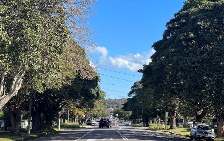 Figure E2.24: Mature trees present in public domain. Figure E2.24: Mature trees present in public domain. | 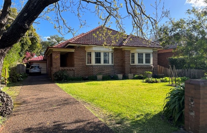 Figure E2.25: Single storey detached bungalow exhibiting characteristics prevalent to the 'Garden Suburb'. Figure E2.25: Single storey detached bungalow exhibiting characteristics prevalent to the 'Garden Suburb'. |
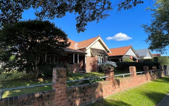 Figure E2.26: Houses showcasing consistent built form, front gardens and side setbacks/side driveway. Figure E2.26: Houses showcasing consistent built form, front gardens and side setbacks/side driveway. | 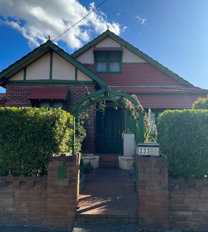 Figure E2.27: Cottage with ornate elements contributing to the distinctive character. Figure E2.27: Cottage with ornate elements contributing to the distinctive character. |
This section applies to land within the Newcastle City Centre Heritage Conservation Area as listed in Schedule 5 and mapped in LEP 2012 - Heritage Maps (HER_004FA, HER_004G and HER_004K). The heritage conservation area is in Newcastle West and Newcastle located between Newcastle railway line, Wright Lane and Newcastle harbour to the north, Watt Street, Pacific Street and Shortland Esplanade to the east, King Street, Queen Street, Laman Street, Gibson Street and Parry Street to the south, Stewart Avenue and Selma Street to the west.
It maps the area for controls provided in Section E1 Built and landscape heritage, and is to be read with that section and the heritage significance and desired future character statements of this section, to understand the heritage requirements.
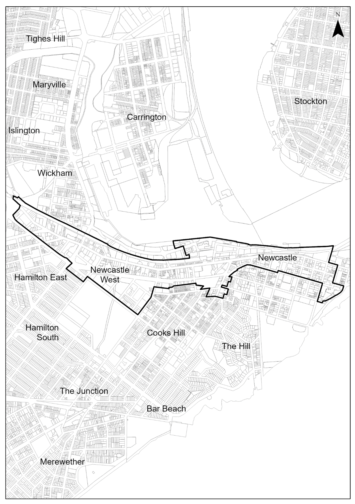 Map E2.07: Land application – Newcastle City Centre Heritage Conservation Area
Key period of significance – circa 1801 to 1940
Newcastle City Centre Heritage Conservation Area is significant on many levels. The mix of commercial, retail and civic buildings is a powerful reminder of the city's past, its economic and social history. Historic buildings provide the backdrop to a city of dramatic topography on the edge of the sea and the mouth of a harbour.
Inner Newcastle has a rich archaeological record of national significance, with potential to yield information about early convict settlement and industrial activities. The heritage conservation area is a place of contact between colonists and Indigenous population. This evidence is available in historical accounts and archaeological record surviving beneath the modern city.
The high numbers of commercial and civic buildings of the 19th and 20th centuries gives a rich historic character which is notable and allows an understanding of the importance as a place of commerce, governance and city building. The historical foundation was the discovery and exploitation of coal with good shipping access via a safe and navigable harbour. The town's layout by surveyor Henry Dangar in 1823 is visible in the streets and is an element of historical value, particularly in the vicinity of Thorn, Keightley, Hunter and Market Streets.
The character of the Newcastle City Centre Heritage Conservation Area is made up of a variety of building styles and settlement patterns that date from the 19th and early decades of the 20th century. The special character is to be preserved, celebrated and maintained through the retention of contributory buildings, open space, street trees, existing subdivision pattern, and elements of visual interest and heritage significance.
Elements to preserve and/or sensitively restore or reconstruct (based on evidence of original appearance) include:
- Range of contributory and historic buildings constructed prior to the Second World War, particularly intact or historically significant groupings, heritage items, iconic structures, and the appearance and layout of streets.
- Existing subdivision pattern and street layout, including preserving the human scale of development, the integrity of laneways and the fine grain of Henry Dangar's 1823 'Old Town' plan in the Newcastle East End Precinct from Pacific Street to Brown Street, and from Church Street to Hunter Street.
- Existing subdivision pattern and street layout, including preserving the human scale of development, the integrity of laneways, the fine grain and the groupings of contributory late 19th century and art deco buildings which predominate in the cultural, educational and administrative Civic Precinct between Brown and Ravenshaw/Steel streets.
- Single to two storey scale of distinctive early industrial and warehouse buildings in Parry Street between National Park Street and Stewart Avenue, and between Wood Street and Railway Street.
- Emerging commercial core of tall and landmark mixed-use retail, office and residential apartment buildings of the Newcastle West End Precinct between Ravenshaw/Steel Street and Wood Street are of high-quality contextual design, compatible with and preserve the remnant contributory 19th century and early 20th century properties and their two to three storey scale and setting, the integrity of laneways and the fine grain of Beresford Lane and Beresford Street.
- Exposed face brick and stone of existing building facades and front fencing.
- Street furniture such as sandstone kerbing and guttering, and other features of historical interest such as heritage items, public stairs, lanes, parks.
- Distinctive early industrial, warehouse and retail buildings, including prominent corner buildings.
- Views and vistas to and from significant cultural landmarks such as the T&G Building and the former Newcastle Post Office. Views which terminate at significant heritage buildings such as Fort Scratchley and the former Newcastle Courthouse. Views from Market Street and Morgan Street to Christ Church Cathedral. Views to the Hunter River are protected and framed along Market Street, Watt Street and Newcomen Street.
- Views to and the visual interconnections between significant Aboriginal cultural landscape features including Whibayganba (Nobbys Head), Tahlbihn (Flagstaff Hill / Fort Scratchley), Burrabihngarn (Pirate Point, Stockton), Yohaaba (Port Hunter), Coquun (Hunter River: South Channel), Khanterin (Shepherds Hill), and Cathedral Park.
- Mature trees in the public domain, and parks and public spaces including Market Street Lawn, Civic Park, Wheeler Place, Museum Park, Christie Place and Birdwood Park.
- Items of heritage significance individually listed as heritage items in Schedule 5 of LEP 2012, including retention of the three-dimensional form and adaptive re-use of heritage item buildings.
- The rich record of relics and archaeological sites beneath the modern city.
The following images demonstrate characteristic features of Newcastle City Centre Heritage Conservation Area.
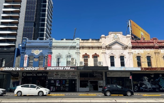 Figure E2.28: Row of buildings with consistent urban form, design elements and fine grain. Figure E2.28: Row of buildings with consistent urban form, design elements and fine grain. |  Figure E2.29: Refurbished early industrial warehouses retaining heritage characteristics. Figure E2.29: Refurbished early industrial warehouses retaining heritage characteristics. |
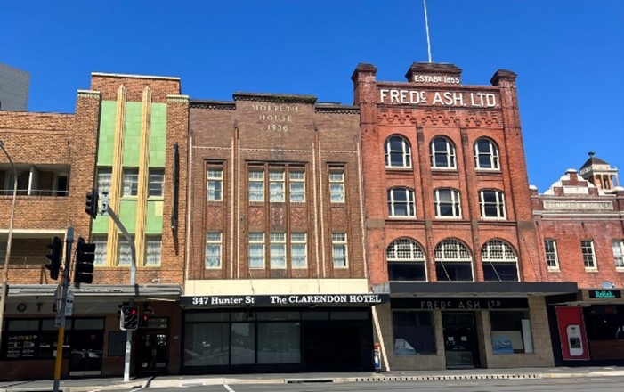 Figure E2.30: Buildings built in mid-19th to early 20th centuries enhance the rich historic character. Figure E2.30: Buildings built in mid-19th to early 20th centuries enhance the rich historic character. | 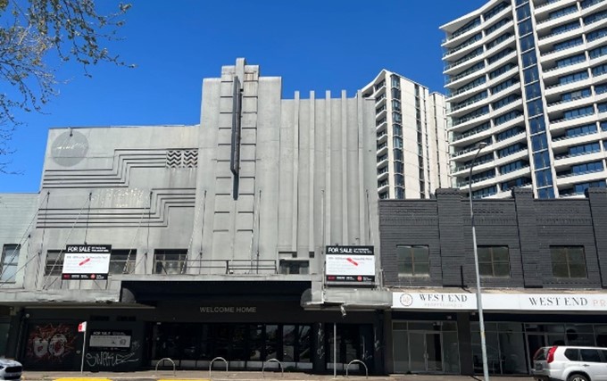 Figure E2.31: Contributory buildings preserving human scale. Figure E2.31: Contributory buildings preserving human scale. |
This section applies to land within the Newcastle East Heritage Conservation Area as identified and mapped in LEP 2012 - Heritage Maps (HER_004K). The heritage conservation area is in Newcastle East located between Newcastle Harbour to the north, the Pacific Ocean to the east and south, Pacific Street and Watt Street to the West.
It maps the area for controls provided in Section E1 Built and landscape heritage, and is to be read with that section and the heritage significance and desired future character statements of this section, to understand the heritage requirements.
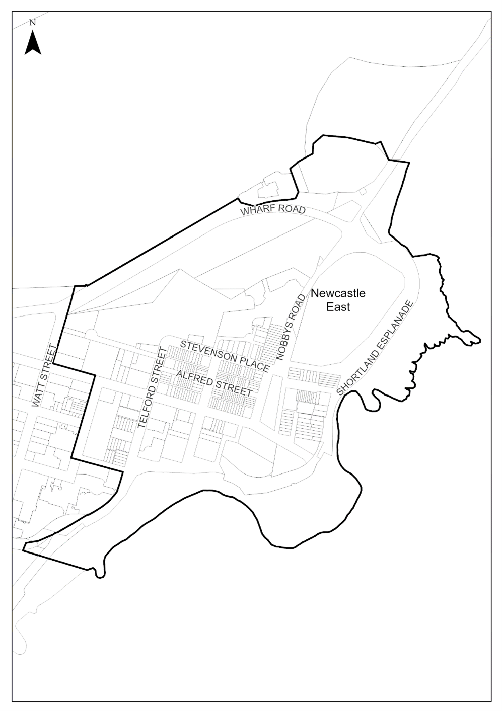 Map E2.08: Land application – Newcastle East Heritage Conservation Area
Key period of significance – circa 1801 to 1940
The Newcastle East Heritage Conservation Area is highly significant as a historic landscape that provides a record of the interaction between the natural environment, including the harbour and the sea, and human settlement. It contains important evidence of Aboriginal life in Newcastle East, uncovered during excavations at the Convict Lumber Yard (CLY) and historical archaeological sites. This evidence allows archaeologists to understand the human and environmental history of the precinct.
Throughout European history the area has been shaped by different activities including being the second penal settlement on the mainland after Sydney (from 1801), the site of the processing and shipping of cedar and coal (CLY), having an important coastal defence installation (Fort Scratchley Historic site), the Nobbys lighthouse and breakwater important to the story of shipping, through to the generation of electricity. The residential area is significant for its consistent streetscapes of two and three storey terrace housing dating from the mid-19th through to early 20th centuries and its housing for workers. There are examples of single storey detached houses.
The social history of Newcastle East is derived from it being the site of early conservation battles in the 1970s, between developers and conservationists and there are rows of public housing that make this place a community and home. It is an important place of recreation at facilities like the Ocean Baths, Nobbys Beach and Foreshore Park.
The character of the Newcastle East Heritage Conservation Area is made up of a variety of building styles and settlement patterns that date from the late 19th and early decades of the 20th century. The special character of Newcastle East is to be preserved and maintained through the retention of contributory buildings, open space, street trees and elements of visual interest and heritage significance such as the many iconic buildings located in Newcastle East, parks and open space, views and vistas, the unique coastal topography and street layout, and the character of the streetscapes including street trees, buildings and the relationship of built elements.
Elements to be preserved and/or sensitively restored or reconstructed (based on evidence of original appearance) include:
- Range of contributory and historic buildings, particularly intact or historically significant groupings, heritage items, iconic structures, and the appearance and layout of streets.
- Existing subdivision pattern and street layout, including preserving the integrity of laneways.
- Two to three-storey scale of housing stock located in the area to the north of Scott Street and east of Telford Street.
- Exposed face brick and stone of existing building facades and front fencing.
- Street furniture such as sandstone kerbing and guttering, and other features of historical interest such as heritage items, public stairs, lanes, parks, views and vistas.
- Regular and homogenous urban form which reflects a regular pattern of subdivision and development, and building stock from between the 1870s and 1930, demonstrating the gradual urbanisation of a once indigenous landscape.
- Existing appearance of Newcastle East, views outwards to the coastline and harbour, and views into the area from Foreshore Park and the Newcastle coastline and Ocean Baths.
- Significant heritage places including the Coal River Precinct, the Nobbys headland and breakwater, Fort Scratchley Historic Site, Convict Lumber Yard and Customs House precinct, the Newcastle Ocean Baths, Joy Cummings Centre and other significant groups such as the Earp Gillam Bond Store Precinct and Stevenson Place terraces.
- Views to and visual interconnections between significant Aboriginal cultural landscape features including Whibayganba (Nobbys Head), Tahlbihn (Flagstaff Hill / Fort Scratchley), Burrabihngarn (Pirate Point, Stockton), Yohaaba (Port Hunter), Coquun (Hunter River: South Channel), Khanterin (Shepherds Hill), and Cathedral Park.
- Mature trees in public domain.
- Public parks and reserves, including Pacific Park, Newcastle Beach, Parnell Place Park, Nobbys Beach, and Foreshore Park.
- Items of heritage significance individually listed as heritage items in Schedule 5 of LEP 2012, including retention of the three-dimensional form and adaptive re-use of heritage item buildings.
- The rich record of relics and archaeological sites beneath the modern city.
The following images demonstrate the characteristic features of the Newcastle East Heritage Conservation Area.
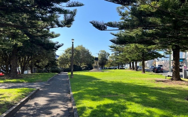 Figure E2.32: Mature trees present in the public domain. Figure E2.32: Mature trees present in the public domain. | 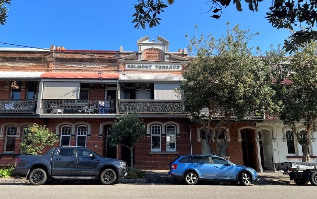 Figure E2.33: Streetscape with two-storey terraces built in the early 20th century. Figure E2.33: Streetscape with two-storey terraces built in the early 20th century. |
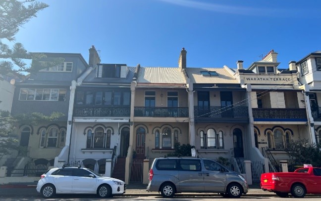 Figure E2.34: Row of three-storey terraces demonstrating the regular pattern of subdivision, ornate elements present in buildings constructed from mid-19th and early 20th centuries. Figure E2.34: Row of three-storey terraces demonstrating the regular pattern of subdivision, ornate elements present in buildings constructed from mid-19th and early 20th centuries. | 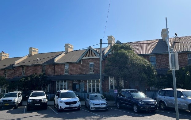 Figure E2.35: Rows of houses significant to Newcastle's history as being one of the first social housing built in Australia. Figure E2.35: Rows of houses significant to Newcastle's history as being one of the first social housing built in Australia. |
This section applies to land within The Hill Heritage Conservation Area as listed in Schedule 5 and mapped in LEP 2012 - Heritage Maps (HER_004G and HER_004K). The heritage conservation area is in Newcastle and The Hill located between King Street to the north, Watt Street and the Pacific Ocean to the east, the Pacific Ocean, Kitchener Parade and Tyrell Street to the south, and the High Street, Lemnos Parade and Darby Street to the west.
It maps the area for controls provided in Section E1 Built and landscape heritage, and is to be read with that section and the heritage significance and desired future character statements of this section, to understand the heritage requirements.
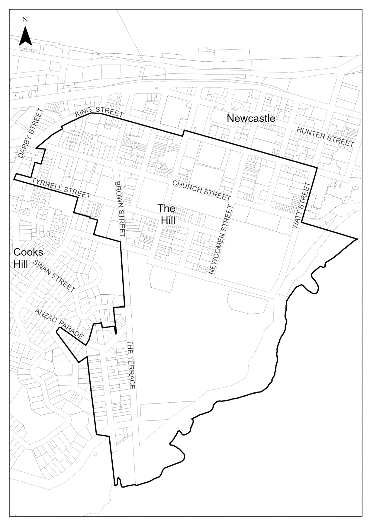 Map E2.09: Land application – The Hill Heritage Conservation Area
Key period of significance – circa 1801 to 1940
The Hill is of outstanding local heritage significance on many levels. It is a significant historic landscape containing numerous heritage items, significant trees, views of the ocean and harbour, and a steep topography that gives it a distinctive character. Its history is multi-dimensional as one of the oldest settled areas and as a place of first European settlement.
There are many significant paintings by early colonial artists including Joseph Lycett, Sophia Campbell and others, depicting European use of The Hill area during the first two decades of settlement, and that depict the traditional owners of the area, the Awabakal, living in this area. The Anglican Cathedral and burial ground are situated at the top of The Hill. The first railway in Australia was located in this precinct, starting at the AAC's A Pit, just off Church Street. The flat bench created for the mine is still visible with the "The Boltons" heritage group now sitting over the site. The funicular railway is significant as the first in Australia, and it was manually powered by the convict labour force.
The heritage conservation area is significant historically for its three AAC coal pits, three earliest private coal mines in Australia, the A Pit, off Church Street, the B Pit, off Swan Street, the C Pit, off Bingle Street, and remains including the winding house at No 18 Bingle Street (see Item No. 2173981). These sites are of high heritage significance as they brought profound changes to the economic fortunes of the colony after 1828 because a coal export trade gained great momentum. The Cathedral and its burial ground have the potential to reveal through their archaeology information about the convict settlement, and despite the repositioning of the graves, the human remains survive in their original resting places.
The Hill Heritage Conservation Area has a strong sense of place and contains highly intact streetscapes with houses, terraces and villas dating from the mid-19th Century through to the late 20th century. There are several residences which date as far back as the 1850s and Claremont House in Newcomen Street which was built in the 1840s, and these are of particular importance. A remnant stone wall (the remains of the Parsonage at the corner of Newcomen and Church Street) dates between 1818 -1820. The sandstone retaining walls are an important historical element in The Hill along with mature trees, gardens and early roads.
The character of The Hill Heritage Conservation Area is made up of a variety of building styles and settlement patterns that date from the late 19th and early decades of the 20th century. The special character of The Hill is to be preserved and maintained through the retention of contributory buildings, open space, the existing subdivision pattern, street trees and elements of visual interest and heritage significance. Such as the many iconic buildings located in The Hill, parks and open space, views and vistas, unique steep topography and street layout, and character of the streetscapes including street trees, buildings and relationship of built elements.
Elements to preserve and/or sensitively restore or reconstruct (based on evidence of original appearance) include:
- Range of contributory and historic buildings, particularly intact or historically significant groupings, heritage items, iconic structures, and the appearance and layout of streets.
- Two storey scale of housing stock that is an original defining feature of the area.
- Exposed face brick and stone of existing building facades and front fencing.
- Sandstone retaining walls, street features such as sandstone kerbing and guttering, and other features of historical interest such as coal shutes, public stairs, lanes, parks, views and vistas.
- Eclectic and organic nature of the urban pattern and varying ages of the building stock that demonstrates the gradual urbanisation during the 19th and 20th century of a once Indigenous landscape.
- Existing appearance of The Hill, views outwards to the coastline and harbour and views into the area from the City, foreshore and Stockton which reveal a treelined suburb with a steep topography.
- Views and visual interconnections between significant Aboriginal cultural landscape features including Whibayganba (Nobbys Head), Tahlbihn (Flagstaff Hill / Fort Scratchley), Burrabihngarn (Pirate Point, Stockton), Yohaaba (Port Hunter), Coquun (Hunter River: South Channel), Khanterin (Shepherds Hill), and Cathedral Park.
- Mature trees in gardens and the public domain.
- Public parks and reserves, including the Newcastle Recreation Reserve, Fletcher Park, and Cathedral Park.
- Existing subdivision pattern and street layout.
- Items of heritage significance individually listed as heritage items in Schedule 5 of LEP 2012 including retention of the three-dimensional form and adaptive re-use of heritage item buildings.
- The rich record of relics and archaeological sites beneath the modern city.
The following images demonstrate characteristic features of The Hill Heritage Conservation Area.
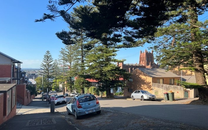 Figure E2.36: The steep topography of The Hill provides vistas to the historic site – Christ Church Cathedral, the ocean and harbour. Figure E2.36: The steep topography of The Hill provides vistas to the historic site – Christ Church Cathedral, the ocean and harbour. | 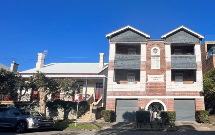 Figure E2.37: Buildings from the early 19th to Mid 20th centuries contributing to the eclectic urban form. Figure E2.37: Buildings from the early 19th to Mid 20th centuries contributing to the eclectic urban form. |
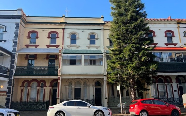 Figure E2.38: Row of three storey terraces with uniform urban form, ornate elements contributing significantly to the historic character of The Hill. Figure E2.38: Row of three storey terraces with uniform urban form, ornate elements contributing significantly to the historic character of The Hill. | 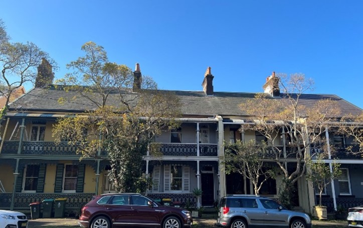 Figure E2.39: Two-storey housing stock - the original defining feature of the area, complemented by street trees. Figure E2.39: Two-storey housing stock - the original defining feature of the area, complemented by street trees. |
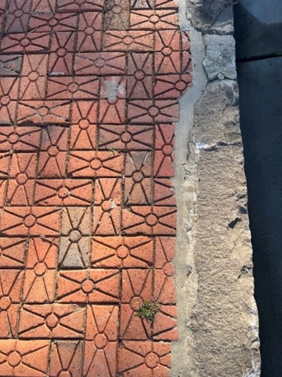 Figure E2.40: Heritage road assets such as sandstone kerbing and restored historic pavements. Figure E2.40: Heritage road assets such as sandstone kerbing and restored historic pavements. |