Section E5 Newcastle city centre
The Newcastle city centre extends from Nobbys Beach and Fort Scratchley in the east to Selma Street at Newcastle West and is bound to the north by the Hunter River and to the south by low density residential development and open space lands.
The city centre central spine is created by Hunter Street and King Street, around which is a diverse range of land uses and several smaller areas with distinct character borne of the natural and built history of Newcastle as well as more recent development which is strengthening the city centre’s role as a vibrant regional hub and attractive destination for businesses, residents and visitors.
Future development will continue the evolution of the city centre as a compact, attractive and people-friendly city reflecting our sense of identity and providing accessible and suitable employment opportunities, a choice of retail and other services, and local, national and international investment opportunities.
This section has performance criteria that explain the planning outcomes to be achieved. Accompanying the performance criteria are design criteria that illustrate the preferred way of complying with the corresponding performance criterion. There may be other ways of complying with performance criteria and it is up to the applicant to demonstrate how an alternative solution achieves this.
Sub-sections 17.0 to 25.0 cover the Character areas and key precincts. All properties within the city centre will fall into one of these areas so should always be considered. The character areas and precincts are not necessarily within heritage conservation areas. However, they can be within or overlap with the boundary of a heritage conservation area.
Note: Applicants for development which interface Newcastle Harbour are advised to engage with the Port of Newcastle prior to lodgement regarding requirements for maintaining navigation aids in this locality to ensure the safe and efficient operation of the Port. The Port of Newcastle inclusive of Newcastle Harbour is a working port which functions 24 hours per day – seven days a week and may at times impact on the amenity of the locality. |
This Section applies to all development within the Newcastle city centre, as is shown in Figure E5.01 or Part 7 of the Newcastle Local Environmental Plan 2012 (LEP 2012).
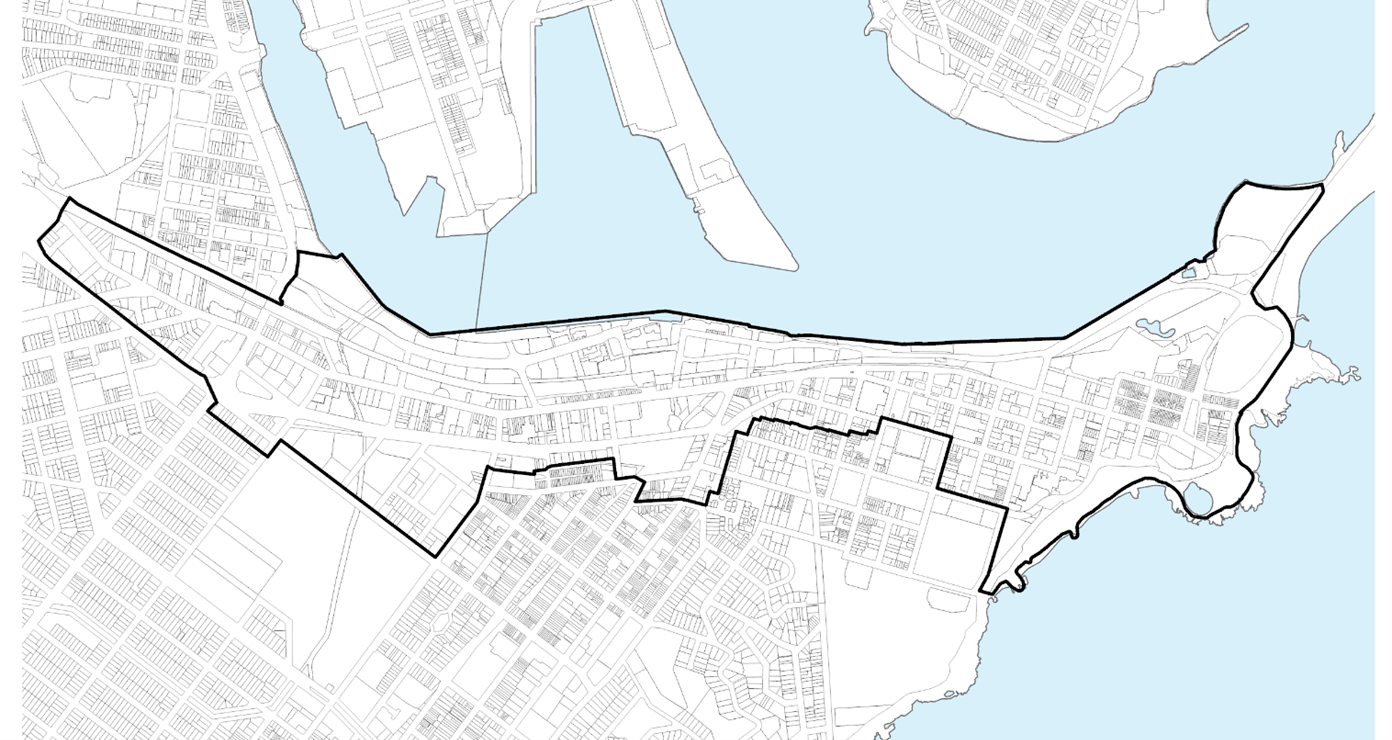 Figure E5.01: Newcastle city centre land application
 For development involving heritage items or heritage conservation areas identified under the LEP 2012, a merit assessment will be undertaken to ensure the outcomes sought are balanced with heritage conservation outcomes.
The following sections will also apply to development:
The following sections may also apply to development:
- B1(a) Flood management - pre 2019 flood studies
- B1(b) Flood management - post 2019 flood studies
- B3 Mine subsidence
- B4 Aboriginal cultural heritage
- B5 Historical archaeology
- B7 Land contamination
- C1 Traffic, parking and access
- C3 Vegetation preservation and care
- C4 Stormwater
- C5 Soil management
- C7 Safety & security
- C8 Social impact
- C9 Advertising and signage
- C10 Street awnings and balconies
- C11 Development adjoining laneways
- C12 Open space and landscaping
- C13 Liveable housing
- E1 Built and landscape heritage
- E2 Heritage conservation areas
Design excellence: Urban design review panel
The urban design review panel (UDRP) provides independent, expert advice to City of Newcastle (CN) and applicants about the quality of the urban design and amenity of developments.
Some types of development must be referred to the UDRP. These include:
- Residential flat buildings
- Shop top housing
- Mixed-use development with residential accommodation component
- Strata subdivision of serviced apartments
Within the renewal corridors, other types of development may be referred to the UDRP due to their nature, location or scale, and likely impact upon the surrounding locality. These include:
- Boarding houses
- Education establishments
- Hospitals
- Multi dwelling and attached dwelling developments comprising ten or more dwellings,
- Place of public worship
- Seniors housings
- Serviced apartment
- Tourist and visitor accommodation
- Modification applications where the development consent to be modified was subject to UDRP advice and the modifications are not minor
- Any other development referred at the discretion of the Manager
The UDRP is an advisory panel only and the advice provided by the panel informs the assessment process. It is not the purpose of the UDRP to have any role in the determination of DAs, nor are its recommendations binding on CN’s determination of an application.
- Facilitate the continued urban renewal of the city centre so that it attracts people of all ages and backgrounds and is reinforced as the business, civic, recreation and cultural hub of the Greater Newcastle Metropolitan Area.
- Provide a comprehensive set of planning and design guidelines based on the built and natural characteristics of distinct areas within the city centre including important views and vistas.
- Promote a thriving and active city centre that is safe and accessible at all times and provides for appropriate connections between residential and employment land uses and transport and public spaces.
- Ensure that new development is of a high architectural standard and contributes positively to the public domain.
- Encourage the greening of streets and public spaces and ensure that future development provides for a high level of sunlight penetration to the street level.
- Encourage sustainable buildings through architectural design, landscaping, building materials and construction practices.
- Enable and support the Newcastle After Dark vision and ensure development generates positive outcomes that align with the Newcastle After Dark, Night-time Economy Strategy.
Development Category | Application requirements | Explanatory Notes |
All applications that include the erection of a new structure or the extension of an existing structure with a height exceeding 10m are to be accompanied with a 3D model of the proposed development within the context of the Newcastle CBD 3D model. | The format should be compatible to that used by CN. Format specification requirements for the model can be provided by CN's Geospatial Information Services team. | The 3D Model should be used to illustrate the following information:
|
Any development that may require an acoustic report or a noise impact assessment. | An acoustic report or noise impact assessment is warranted when a noise-producing development is proposed near noise-sensitive areas or, conversely, when a noise-sensitive development is proposed in a noisy area. An acoustic report should:
Ensure any recommendations concerning acoustic attenuation are feasible and can be practically implemented. | Newcastle After Dark Strategy - Night-time Economy Strategy reiterates that a developer responsible for building a residential complex needs to ‘design in’ reasonable noise mitigation (for example double glazing). Conversely, a late-night venue seeking to extend venue space or hours of operation which may include live performance would need to ensure noise impacts are appropriately defined and managed through preparation of a plan of management. Refer to C7 Safety and Security. Trading hours are to consider the status of a licensed venue as low or greater impact. Growth in the late-night economy (12am - 4am) must represent low impact venues to facilitate continued progress in venue diversity. A venue will be classified as low impact or otherwise throughout the development assessment process based on relevant matters for consideration. A low impact venue may be a small bar or smaller local business that contains low levels of impact on the surrounding environment. A Pub (as defined under LEP 2012) is not a low impact venue and would automatically be classified otherwise due to potential for larger or more cumulative impacts on the surrounding environment. A noise-producing development or noisy area may have a range of activities contributing to noise and is not limited to that produced from busy roads, railways, industries, live music venues, entertainment, gymnasiums, public parks and plazas in which people may congregate or host live music or events. A noise-sensitive development may include but is not limited to residential accommodation, educational establishments, early education and childcare facility, health services facility, place of public worship or the like. More guidance can be found in the Noise Guide for Local Government, 2023 (NSW Environment Protection Authority) and, Approved Methods for the Measurement and Analysis of Environmental Noise in NSW, 2022 (NSW Environment Protection Authority). |
Any development for buildings equal to or greater than 24m in height or at the discretion of CN, is to submit a Wind Effects Report. | A Wind Effects Report is to be prepared and submitted by a suitably qualified wind engineer. The Wind Effects Report must consider the potential wind impacts and the likely extent of wind impacts of the proposed building on private and communal outdoor areas. Where unacceptable safety or comfort levels are found, design adjustments are made to mitigate any likely adverse wind impacts. | New developments in established urban areas are typically taller than surrounding buildings. Taller buildings intensify windy conditions which can adversely affect pedestrian safety and comfort and impact the amenity of outdoor areas including the public domain and private and communal outdoor spaces. |
An application for development including change of use involving building work. | An access report identifying the relevant matters to be addressed at the construction certificate stage, in circumstances where access constitutes a substantive public interest aspect of a proposal. Access reports should be prepared by a person who is a suitably qualified access consultant, such as a person who is appropriately accredited by the Association of Consultants in Access Australia Inc. | The Disability (Access to Premises – Buildings) Standards 2010 applies to any part of a building impacted by the application for a change of use. This section does not require anything beyond the standard, but does require information on how the standard will be met through the building design in accordance with these application requirements. There may also be other standards under the Disability Discrimination Act 1992 relevant to the public interest assessment of a proposal, such as the Disability Standards for Education 2005. |
An application for a change of use not involving building work. | An access report to consider access matters, in circumstances where access constitutes a substantive public interest aspect of the proposal. Access reports should be prepared by a suitably qualified access consultant, such as a person appropriately accredited by the Association of Consultants in Access Australia Inc. | A change of use not involving building works may generate public interest considerations relevant to the assessment of a DA, including in circumstances where it is apparent that a building may not comply with the access requirements of the Building Code of Australia. |
All development within or adjacent to nominated view corridors (as per Figure E5.13), or that exceeds the street wall height, is to be accompanied by a visual impact assessment. | Visual Impact Assessment to:
| Refer to Guideline for landscape character and visual impact assessment - Environmental impact assessment practice note EIA-N04 (Transport for NSW, 2023). |
Street wall heights refer to the height of the building that is built to the public street or lane, measured from the ground level up to the first building setback. The street wall height works in combination with a setback above to balance a sense of enclosure to the street whilst preventing an overbearing sense of confinement. This ‘human scale’ enables sunlight access to the public domain and to adjoining sites and provides for glimpses of surrounding landmark features for wayfinding and a sense of place. Street wall heights typically relate to the street width, often at a ratio of 1:1, and help to provide a consistent building scale in streets that have a mix of uses whilst respecting heritage items and contributory buildings.
Objectives
- Ensure that street wall heights and upper level setbacks contribute to a visually appealing and pedestrian-friendly urban environment, while ensuring that new development is compatible with the existing context of the area.
- Promote sustainable development that enhances the public realm and supports the health and wellbeing of the community by setting requirements for street wall heights and upper level setbacks that enable adequate sunlight penetration, encourage active street frontages and public spaces, and preserve key view corridors.
Performance criteria (PC) | Design criteria (DC) | Explanatory Notes |
PC-1. Street wall heights and upper level setbacks of new buildings will:
| DC1-1. The street wall height of new buildings or alterations and additions to existing buildings shall be between 8m and 22m or as specified in the controls for each Character Area. DC1-2. In all circumstances, the street wall height shall be a minimum of 8m allowing for two storeys accommodating ground floor commercial with a minimum floor-to-ceiling of 4m and a first floor with a minimum floor-to-ceiling of 3.3m capable of being adapted for commercial. Greater floor-to-ceiling heights may be required to accommodate some land uses (such as restaurants and cafes) or to respond to the proportions of heritage buildings. DC1-3. Above the street wall height an average setback of 6m from all street frontages shall be provided, as shown in Figure E5.02. This setback may be reduced by 1.5m for up to 30% of the building width measured at the relevant facade, provided that no part of the building structure is less than 4.5m from the street wall alignment as shown in Figure E5.03. Greater setbacks may be appropriate for heritage buildings or to respond favourably to nearby heritage items or contributory buildings. DC1-4. In some circumstances, it may be appropriate for corner sites to be emphasised by an additional street wall height and/or a reduction in the required upper level setback presenting to the corner, subject to achieving the performance criteria. | Refer to Section E1 Built and Landscape Heritage and E2 Heritage conservation areas. Heritage items are identified under Schedule 5 of LEP 2012. Contributory buildings are identified in the Contributory Buildings Maps in the Newcastle Heritage Technical Manual. |
PC-2. All applications that include the erection of a new structure or the extension of an existing structure with a height exceeding 10m are to be accompanied with a 3D model of the proposed development. | See sub-section 5.0 application requirements for further information. Figure E5.02: Street wall height and upper level setbacks |
|
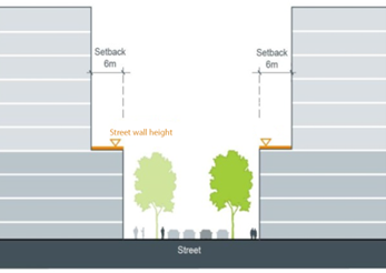 Figure E5.02: Street wall height and upper level setbacks |
| |

A building setback is the distance between the boundary of the site and the main building facade or outer edge of projecting elements such as a balcony.
At the ground level, building setbacks help define street edges and create opportunities for defining and interfacing public and private spaces, providing landscaping, and improving pedestrian movements around and between building structures. At upper levels, building setbacks enable sunlight access, ventilation, outlook and privacy for surrounding sites and the public domain and can assist to create or maintain views and vistas.
Building separation is the distance between buildings on the same site or buildings on adjoining sites. Building separation works in combination with setbacks to provide a consistent rhythm of spaces between built elements enabling daylight penetration to buildings and ground level spaces, views to the sky from the ground level public domain and natural ventilation.
Objectives
- Ensure that building setbacks create a consistent street edge and interface with the public domain through landscaping, while providing for high-quality building entries that enhance pedestrian mobility and create visual interest.
- Set consistent building heights and setbacks that enable solar access, ventilation, outlook, and privacy for both existing and future surrounding development.
- Ensure that setbacks provide adequate daylight penetration to the ground level public domain and support a healthy environment for street trees and landscaping, while preserving views to the sky from public spaces.
- Protect views and vistas by setting requirements for setbacks that preserve key view corridors and encourage new development to enhance or maintain existing views.
Performance criteria (PC) | Design criteria (DC) | Explanatory note(s) |
PC-1. Building setbacks and separation will:
| DC1-1. The ground level shall be built to the street frontage or as otherwise specified in the controls for each Character Area unless:
DC1-2. Where a ground level setback is provided, it may contain pedestrian areas, steps, ramps, landscape features and the like but should not contain utility structures or barriers that restrict visual permeability or pedestrian movement or create opportunities for crime or antisocial behaviour. DC1-3. Where a ground level setback is required by this section, basements shall also be setback to provide opportunities for deep soil landscaping within the ground level setback. DC1-4. Behind the street alignment and up to the street wall height, buildings shall be built to the side and rear boundaries to create a podium, other than:
DC1-5. Above the street wall height a minimum setback of 6m from all boundaries shall be provided other than permitted. DC1-6. For mixed-use or residential development, boundary setbacks above the street wall height shall comply with building separation requirements of the Apartment Design Guide. Greater setbacks may be required where existing adjoining development does not provide for half of the building separation required by the Apartment Design Guide and is unlikely to be redeveloped within a reasonable timeframe. DC1-7. For non-residential development, upper level setbacks above the street wall height shall have regard to existing and potential future buildings on surrounding sites. Where surrounding buildings contain, or are likely to contain, residential land uses, the building separation requirements of the Apartment Design Guide shall apply. Where surrounding buildings contain non-residential land uses, side and rear boundary setbacks above the street wall height shall be as per Figure E5.04. which provides for:
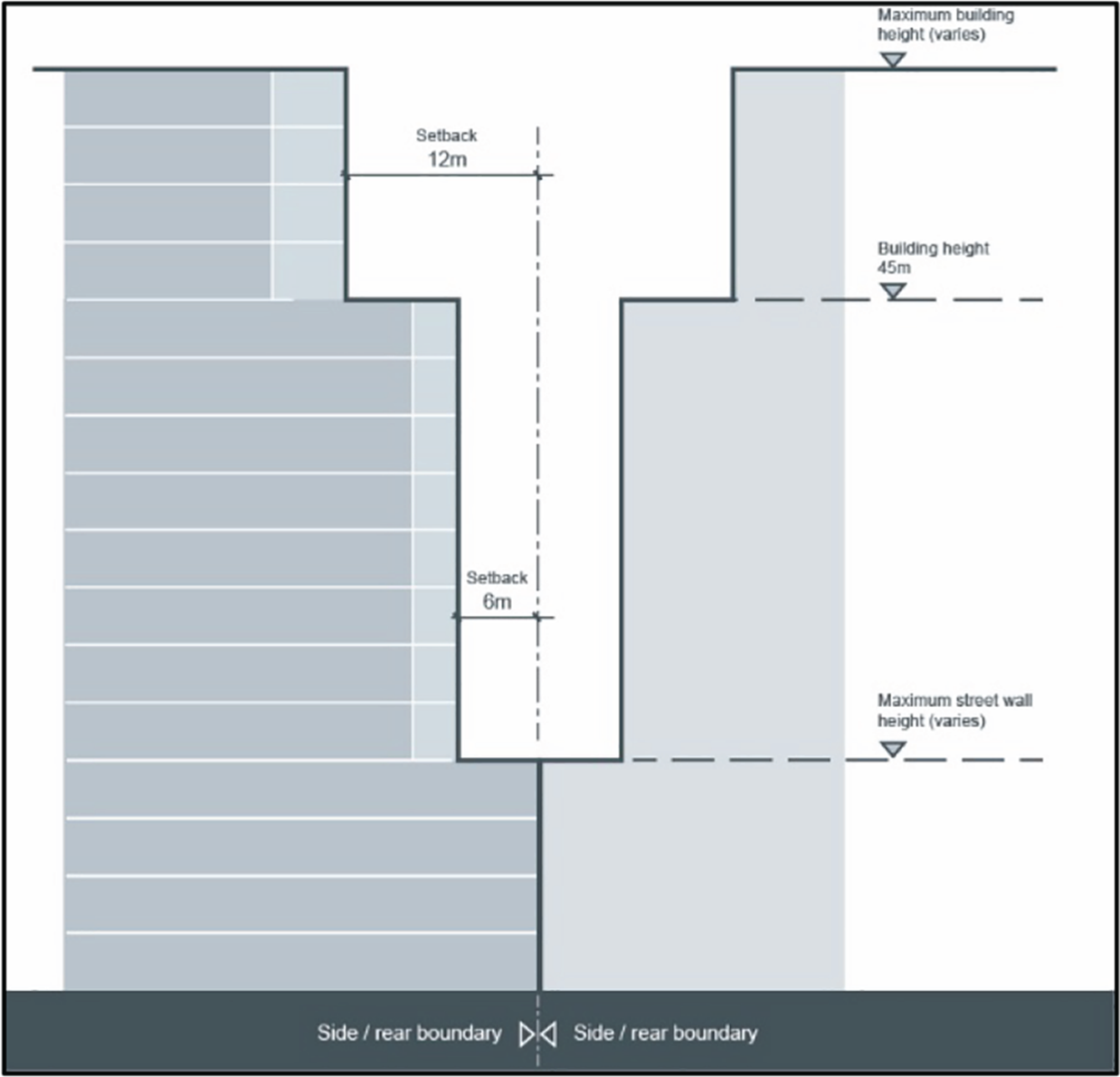 Figure E5.04: Building setbacks for non-residential buildings on adjoining sites Figure E5.04: Building setbacks for non-residential buildings on adjoining sitesDC1-8. Minor incursions into the setback area may be permitted for non-trafficable articulating elements, sun shading devices and awnings that are integrated into the overall building design. DC1-9. Within a site, separation between non-residential buildings may be as per Figure E5.05 which provides for:
|
|
Limiting the maximum dimension and floorplate of buildings, particularly tower forms, reduces visual bulk, enables daylight penetration to buildings and ground level spaces, permits views to the sky from the ground level public domain, improves natural ventilation and minimises wind impacts. In residential buildings, building dimensions and floorplates also play an important role in residential amenity by reducing the number of apartments per level and minimising single orientation apartments.
Objectives
- Ensure building dimensions and floorplates promote a slender tower form with articulated facades above the street wall height, while ensuring that new development is compatible with the existing context of the area.
- Promote sustainable development that enhances the public realm and supports the health and wellbeing of the community by minimising adverse wind impacts and the creating a comfortable and safe urban environment
Performance criteria (PC) | Design criteria (DC) | Explanatory note(s) |
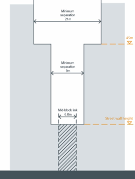
PC-1. Dimensions and floorplates of buildings above the street wall height should provide for a slender tower form with articulated facades. | DC1-1. Residential buildings above the street wall height shall comply with the building depth and floorplate requirements of the Apartment Design Guide. Where no floorplate is expressed in the Apartment Design Guide, a maximum floorplate of 700m2 shall apply as shown in Figure E5.06. DC1-2. Non-residential buildings above the street wall height shall have a maximum floorplate of 1,200m2 as shown in Figure E5.07. DC1-3. The maximum dimension for any tower form above the street wall height shall be 50m, being the linear distance between two opposing facades of a building envelope and including balconies and external circulation but excluding minor projecting articulating elements as shown in Figures E5.06 and E5.07. DC1-4. Where a building facade has a dimension of 25m or more, it must be separated into at least two parts by an articulating element with minimum dimensions of 3m wide by 3m deep as shown in Figures E5.06 and E5.07. This should not result in a reduction to the required setback other than permitted. | 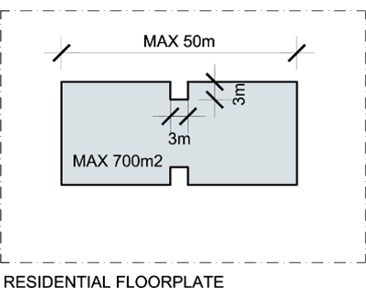 Figure E5.06:Maximum floorplate, dimension and articulation requirements for residential towers above the street wall height Figure E5.06:Maximum floorplate, dimension and articulation requirements for residential towers above the street wall height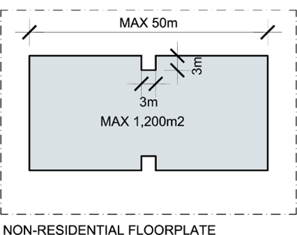 Figure E5.07: Maximum floorplate, dimension and articulation requirements for non-residential towers above the street wall height Figure E5.07: Maximum floorplate, dimension and articulation requirements for non-residential towers above the street wall heightThe maximum building dimension may be limited by factors such as the building depth requirements of the Apartment Design Guide. A Wind Effects Report is to be submitted in accordance with the application requirements. |
PC-2. New development minimises adverse wind impacts within development sites, surrounding land and public spaces. | DC2-1. To ensure public safety and comfort, wind effects caused by new buildings or substantial alterations and additions to existing buildings must not exceed:
DC2-2. New buildings or substantial alterations and additions to existing buildings should incorporate building elements and landscaping to minimise wind impacts on the private and communal spaces within development sites and adjoining land. DC2-3 .A Wind Effects Report, prepared by a suitably qualified person, shall be submitted with any DA for buildings equal to or greater than 24m in height or at the discretion of the CN. DC2-4. For buildings equal to or over 45m in height, results of a wind tunnel test are to be included in the Wind Effects Report. |
Building facades contribute to the character of the area, help to activate street frontages and provide visual interest when viewed from the public domain or from surrounding buildings. Facades of high design quality utilise vertical and/or horizontal articulation which respond to surrounding structures, as well as textures, materials and colours that respond to the desired character, including existing heritage buildings. External material selection and building design can assist to respond to the area character, minimise energy use, reduce ongoing maintenance costs and minimise noise transmission in the city centre.
Objectives
- Require new building facades and exteriors to contribute positively to the streetscape by ensuring that design is sympathetic to the site's context, that materials and finishes are durable and energy-efficient, and that unsightly visually dominating features are avoided.
- Ensure that building facades and exteriors incorporate materials and finishes that are durable, energy-efficient and suitable for the local climate.
- Promote the legibility of the street environment and encourage activity on highly visible and accessible street corners by requiring design measures that enhance the building's presence at street level, such as corner articulation, public art, or other public-facing features.
- Address the issue of noise transmission in the city centre by ensuring building facades and exteriors are designed to minimise noise pollution from nearby sources of noise.
Performance criteria (PC) | Design criteria (DC) | Explanatory note(s) |
PC-1. Building facades and exteriors shall be designed to:
| DC1-1. Buildings shall be designed and articulated to provide:
DC1-2. Visually integrate with the surrounding area and adjoining buildings through appropriate design, including articulation that responds to datum lines of key components of adjoining buildings such as street wall height, street setback, awnings, parapets, cornice lines and setbacks above street wall height. DC1-3. Large expanses of blank, unarticulated facades of the same or similar material, including reflective glass, are to be avoided. DC1-4. Where the orientation and acoustic environment permits, windows, balconies, terraces and communal open spaces are positioned to overlook public spaces such as parks, streets and pedestrianised areas. DC1-5. Roof lines are to be designed to create a visually interesting skyline with roof plant and lift overrun integrated into the overall architectural design of the building. DC1-6. Development shall minimise the use of virgin materials, maximise energy efficient materials and use durable materials and finishes to reduce ongoing maintenance costs. Subject to compatibility with the desired character of the area, face brickwork, stone, concrete and glass are encouraged. DC1-7. Building facades should not result in glare that causes discomfort or threatens safety of pedestrians or drivers. DC1-8. Mirror glass with a reflectivity in excess of 15% must be avoided. DC1-9. Subject to the extent and nature of glazing and reflective materials used, a Reflectivity Report that analyses potential solar glare from the proposed development on pedestrians or motorists may be required. DC1-10. Exterior facades are designed to minimise the opportunity for sound transmission. Depending on surrounding land uses and the nature of the proposal, an acoustic report or noise impact assessment may be requested demonstrating how sound transmission is minimised. | For further guidance on noise attenuation, applicants should explore the relevant sections of the National Construction Code, associated handbook, including:
And the relevant NSW Environment Protection Agency guidelines, being:
|
PC-2. Buildings on highly visible and accessible street corners incorporate design measures on the corners to assist in legibility of the street environment and promote activity on the street frontage. | DC2-1. Buildings within a mixed use or employment zone located at the junction of street corners:
| Design measures will vary depending on the building, its location and setting, however may include the following:
Where above-ground infrastructure, service pillars or cabinets are located in the middle of the footpath as a result of a corner truncation, development relocates the infrastructure to the new boundary. |
Awnings protect pedestrians and other users of the ground level public domain from sun, rain and wind and thereby encourage active streets which support and enhance the vitality of the area. In addition, awnings work in combination with building entries to contribute to the identity of a development. Awnings can be prominent built elements in the streetscape and require careful design to ensure that they respond to context, are well-integrated into the overall building design, enable street trees to flourish and an appropriate level of signage for commercial activities within buildings.
Objectives
Ensure awnings are consistent with the controls in C10 Street awnings and balconies.
Performance criteria (PC) | Design criteria (DC) | Explanatory note(s) |
PC-1. Awnings are considered as part of the overall development and designed accordingly. | DC1-1. Awnings are in accordance with the relevant awning provisions contained separately in C10 Street awnings and balconies. |
|
Wherever possible, providing the required car parking within a basement, or below ground level, maximises the opportunities for street activation and most efficiently uses the above ground building envelope for the active component of residential and non-residential land uses
Notwithstanding, environmental constraints such as a high water table, mine subsidence and flooding may dictate that some car parking be provided above ground level. In such circumstances, the aboveground car parking component must be designed in such a way that it does not result in adverse visual impacts and does not detract from the ability of developments to provide active interfaces with and natural surveillance of the public domain.
Objectives
- Prioritise the use of basements or below ground level parking to provide car parking for both residential and non-residential land uses. Where parking is aboveground, it is designed to minimise adverse visual impacts and maintain the ability of developments to provide active interfaces with the public domain.
Performance criteria (PC) | Design criteria (DC) | Explanatory note(s) |
PC-1. Car parking structures are to be well designed in order to:
| DC1-1. Car parking and loading access points shall be designed to be integrated into the overall building design and shall be recessed into the street facade. The walls of the recess shall be treated with high quality materials in the same manner, or similar to, the main facade. DC1-2. Car parking shall be designed to minimise flood waters from entering car parking levels by:
DC1-3. Car parking should be contained within the building footprint and preferably within a basement. DC1-4. Where on-site parking cannot be provided within the building footprint it must be located to the side or rear of the building and not be visible from the street frontages. DC1-5. Where environmental constraints such as high water table, mine subsidence or flooding limit the extent of basement car parking, up to 50% of the required car parking may be provided at the ground level or above ground, subject to the Design Criteria within this section. DC1-6. At-grade or above ground car parking must be screened from view from public spaces by:
DC1-7. Car parking provided at or above ground level has horizontal flooring and a minimum floor to ceiling height of 4m with a minimum clearance height of 3.5m. For the next two floors above, the floor to ceiling height is to be 3.3m. This will enable the development to being adapted to an alternative use in future and to provide for service vehicles. | For further information regarding parking see Section C1 Traffic, Parking and Access.   Figure E5.08: Screened car parking solutions Figure E5.08: Screened car parking solutionsRequirements for review of DAs for aboveground car parking structures by the Urban Design Review Panel should form part of the terms of reference for that group and should be specified as a requirement in the DA Lodgement Guidelines. |
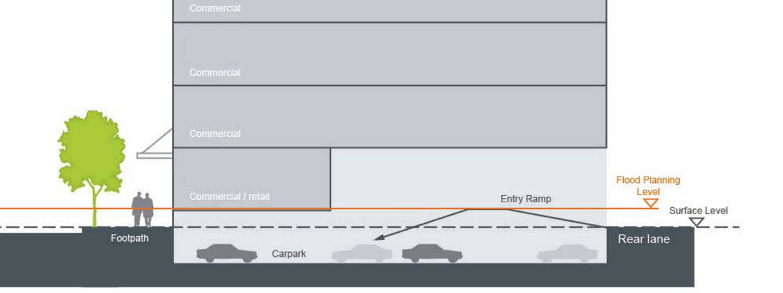 Figure E5.09: Basement ramp design to minimise flood inundation
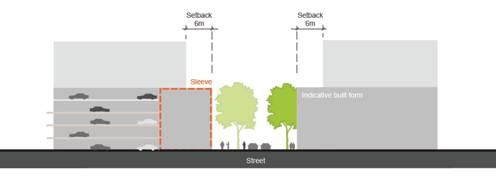 Figure E5.10: Sleeved car parking solution
Landscape design works in harmony with, and complements, built form and can assist to respond to the desired character of the area as well as existing natural environmental features of the locality. In the city centre, opportunities for ground level soft landscaping will be limited by the built form controls in this section, yet soft landscaping can still play an important role in providing a human scale to streets, reducing urban heat gain, improving air quality and connecting existing parks and foreshore areas.
Given the limitations for ground level soft landscaping, buildings should be designed to incorporate landscaped areas which may incorporate both private and communal open spaces. In addition, when appropriately oriented and designed, vertical landscaping in the form of green walls and roofs can add to the visual interest of the area and screen unsightly structures.
Objectives
- Retain and incorporate mature trees in the development to enhance the character of the area, provide amenity to residents and visitors, and contribute to the microclimate
- Ensure that landscaping and open spaces are integrated into the development design to complement building structures and contribute to quality public spaces.
- Minimise the visual impact of car paking and servicing areas on the street frontage through appropriate design and landscaping measures.
- Provide adequate shade and shelter in open spaces, car parking areas, and public spaces to enhance the microclimate and contribute to quality public spaces.
Performance criteria (PC) | Design criteria (DC) |
PC-1. Landscaping and open spaces:
| DC1-1. Native ground covers and grasses are to be used in garden beds and path surrounds. Turf should be confined to useable outdoor areas. DC1-2. The design of exterior private open spaces such as roof top gardens is to address visual and acoustic privacy, safety, security, and wind effects. DC1-3. Where roof gardens and green walls are provided, consideration should be given to the Urban Green Cover in NSW – Technical Guidelines, published by the Office of Environment and Heritage. DC1-4. Communal open space shall be provided in accordance with the Apartment Design Guide and shall achieve:
DC1-5. Wherever street setbacks and site constraints permit, a portion of communal open space located at ground level is encouraged. DC1-6. Outdoor communal open space is to be capable of accommodating substantial vegetation and shall incorporate active and passive recreation facilities (such as seating, shade structures, BBQs, children’s play equipment and swimming pools). DC1-7. Communal open spaces are to include passive surveillance from adjacent internal living areas and/or pathways, and be in addition to any public thoroughfares. |
Utilities and service infrastructure is required to facilitate development however, if the location and design of infrastructure is not considered early in the design process, it can have a significant adverse effect on the overall aesthetics of buildings and public spaces.
Objectives
- Minimise the visual impact of building utilities and services to the street, public domain, and neighbouring buildings
- Ensure that building services such as substations and mailboxes are integrated into the overall building design, are complementary to the building fabric, and do not dominate the street elevation or public areas.
Performance criteria (PC) | Design criteria (DC) |
PC-1. Visual clutter and visual bulk of new development is reduced by appropriately locating, orientating and screening services such as substations, hydrant boosters and mailboxes. | DC1-1. Services, including air conditioning, plant equipment, are screened from the street, public domain and neighbouring buildings by elements such as landscaping, fencing or walls, to ensure that they are not visible from the street, neighbouring buildings or public domain. DC1-2. Substations must be integrated into the overall building design, be complementary to the building fabric and wherever possible, not be located in public areas or be visible from the public domain. DC1-3. Ventilation stacks servicing basement garages should not occur in the street setback or any common open space and should be concealed within the building. DC1-4. Mailbox design and location should comply with Australia Post requirements (multi-storey residential premises). DC1-5. Larger developments should provide mailboxes internally in common foyers. DC1-6. Mailboxes shall be in a location with passive surveillance and lighting to discourage mail theft. DC1-7. Mailbox structure/s should not dominate the street elevation and should harmonise with the building aesthetic and landscape treatments. DC1-8. Mailbox points are to be integrated into the building design, preferably embedded into a wall. DC1-9. Mailbox groups should be perpendicular to the street (rather than parallel to the site frontage) to minimises visual clutter on the street. |
Objectives
- Provide awareness of the obligations under the Commonwealth's Disability Discrimination Act 1992
Performance criteria (PC) | Design criteria (DC) |
PC-1. An application for development including change of use is to provide an access report in accordance with the application requirements above. |
|
The design of the access network determines how people will move about and underpins how the city centre functions. Pedestrian activity can be encouraged by developing a fine grain, connected and legible street and lane network that integrates pedestrians, cycling and public transport.
Encouraging an active transport (walking and cycling) network can improve commercial, social and health outcomes while reducing congestion, noise, pollution, and the dangers of vehicle collisions. Active transport promotes well-being and reduces the environmental impacts of congestion. It is critical that streets and bike networks are safe, attractive and well connected to promote active transport.
Objectives
- Ensure that the access network prioritises pedestrian, cycling, and public transport use over private vehicle access and movement to support sustainable and active travel behaviour.
- Retain, enhance, and ensure the safety of lanes, through-site links, and pedestrian paths to promote access and public use during the day and night.
- Ensure that the street and block network is permeable and accessible to promote pedestrian use and encourage sustainable and active travel behaviour.
- Ensure that cycling routes are safe, connected, and well-designed to promote cycling as a sustainable and active mode of transportation.
Performance criteria (PC) | Design criteria (DC) | Explanatory note(s) | |
PC-1. The access network prioritises pedestrian, cycling and public transport uses to support sustainable and active travel behaviour over private vehicle access and movement. | DC1-1. Improved and new pedestrian connections and laneways are to be provided as specified in the controls for each Character Area and in accordance with the City Centre Public Domain Technical Manual. DC1-2. Sites with a street frontage shall incorporate footpaths and additional pedestrian connections to improve access and permeability in accordance with C2 Movement Networks. | All development is expected to incorporate pedestrian connectivity, access and permeability. | |
PC-2. Lanes, through-site links and pedestrian paths are retained, safe and enhanced to promote access and public use during the day and night. | DC2-1. New pedestrian connections and laneways shall have regard to the location of existing or planned service lanes, pedestrian crossings and public transport nodes. DC2-2. New pedestrian connections and laneways should be connected to avoid dead ends or cul-de-sacs, be legible and clear of obstructions (including columns, stairs and storage) and should incorporate wayfinding measures integrated with the public domain. DC2-3. Streets and lanes are connected to encourage pedestrian use. DC2-4. Pedestrian bridges are avoided over public spaces, including lanes. DC2-5. Development adjacent to a lane or pedestrian path includes:
DC2-6. Streets, lanes and footpaths include lighting and illumination in accordance with the requirements of the City Centre Technical Manual. DC2-7. Blank walls and solid fencing that inhibit natural surveillance and encourage graffiti should be avoided. DC2-8. Laneways, paths and through site links incorporate Crime Prevention Through Environmental Design (CPTED) principles. DC2-9. Laneways should be publicly accessible 24 hours, 7 days per week. DC2-10. Laneways are open to the air above for the majority of their length. City of Newcastle (CN) may consider an ‘arcade style’ walkway where the space has an ‘open feel’ and is well lit. DC2-11. Creative lighting installations within lanes and through-site links are encouraged. | Lighting within a heritage conservation area and/or within proximity to heritage item/s is designed sympathetically to the heritage significance and desired future character of the heritage item/s and/or heritage conservation area. Refer to Section E1 Built and Landscape Heritage and Section E2 Heritage conservation areas. | |
PC-3. Street and block network is permeable and accessible to promote pedestrian use. | DC3-1. Through-site connections on privately owned land shall be as shown in Figure E5.11.
DC3-2. Residential developments with a frontage to a through site link incorporate windows, doors and verandahs facing the through-site link at ground level. DC3-3. Arcades in retail and commercial developments shall be as shown in Figure E5.12.
| Easements will be imposed over these areas to ensure public access is maintained in perpetuity. Consideration of CPTED is important when designing the street and block network. Further information can be found in Section C7 Safety and Security, including when a crime risk assessment may be required as part of the submission. | |
PC-4. Cycle routes are safe, connected and well-designed. | DC4-1. Cycle ways are connected into the network indicated in the latest resource or publication by CN and accessible to public transport stops. DC4-2. Safety is maximised through active street frontages. Buildings that adjoin pedestrian and cycle paths are designed to address the path and provide passive surveillance opportunities. DC4-3. Signage should be provided along cycle routes identifying key destinations, transport stops, bicycle parking, travel times and distances. DC4-4. Commercial development includes end of trip cycling infrastructure. Design solutions include secure bike parking, showers and change room facilities. DC4-5. Cycling routes and cycle parking are coordinated and integrated with the location of public transport stops to enable convenient mode change. | Resources or publications that identify the cycling network may include, but is not limited to, hard copy or digital mapping, adopted strategy, or the like. | |
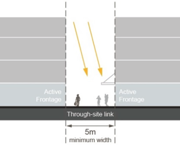 Figure E5.11: Through-site connections on privately owned land Figure E5.11: Through-site connections on privately owned land | 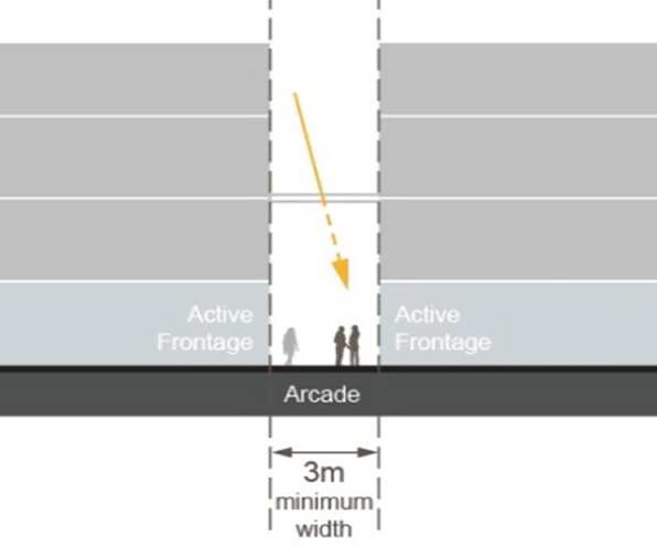 Figure E5.12: Arcades in retail and commercial Figure E5.12: Arcades in retail and commercial | ||
Preserving significant views around the city is critical to place-making, wayfinding and for retaining the unique character of Newcastle. Significant views include views from public places towards specific landmarks, heritage items and areas of natural beauty. Some of the most important views in Newcastle are along streets leading to the water or landmark buildings, including Christ Church Cathedral, Fort Scratchley and Nobby's Head.
With the redevelopment of the former rail corridor lands, key views and vistas are to be established and will create a visual connection and link the city to the foreshore.
Objectives
- Preserve and enhance public views and sight lines to key public spaces, the waterfront, prominent heritage items, landmarks and landscape features.
Performance criteria (PC) | Design criteria (DC) | Explanatory note(s) |
PC-1. Public views and sight lines to key public spaces, the waterfront, prominent heritage items, landmarks and landscape features are protected. | DC1-1. New development retains and improves the views nominated in Figure E5.13. DC1-2. New development in the vicinity of views to Christ Church Cathedral must ensure that vistas of the Cathedral’s tower, roof-scape and pinnacles of the buttresses are preserved. DC1.-3. Open space, breaks and setbacks in the built form align with existing streets and view corridors to key public spaces, the waterfront, prominent heritage items, landmarks and landscape features including but not limited to those identified in Figure E5.13. DC1-4. The height and bulk of development shall ensure that significant views including those nominated in Figure E5.13 are protected. DC1-5. All development within or adjacent to nominated view corridors (as per Figure E5.13), or that exceeds the street wall height is to be accompanied by a visual impact assessment demonstrating how this performance criteria has been met. See application requirements for further information. DC1-6. Where views are potentially compromised, an assessment of the view loss must be undertaken having regard to ‘Impact on public domain views’ of the NSW Land and Environment Court (presently Rose Bay Marina Pty Limited v Woollahra Municipal Council and anor [2013] NSWLEC 1046). | Examples of viewable landmarks and landscape features worthy of retention include, but are not limited to:
Refer to Section E2 Heritage conservation areas. A visual impact assessment identifies and analyses the affected views in their existing state, includes photomontages of the view once the proposed development is in place and then assess the impact on that view. |
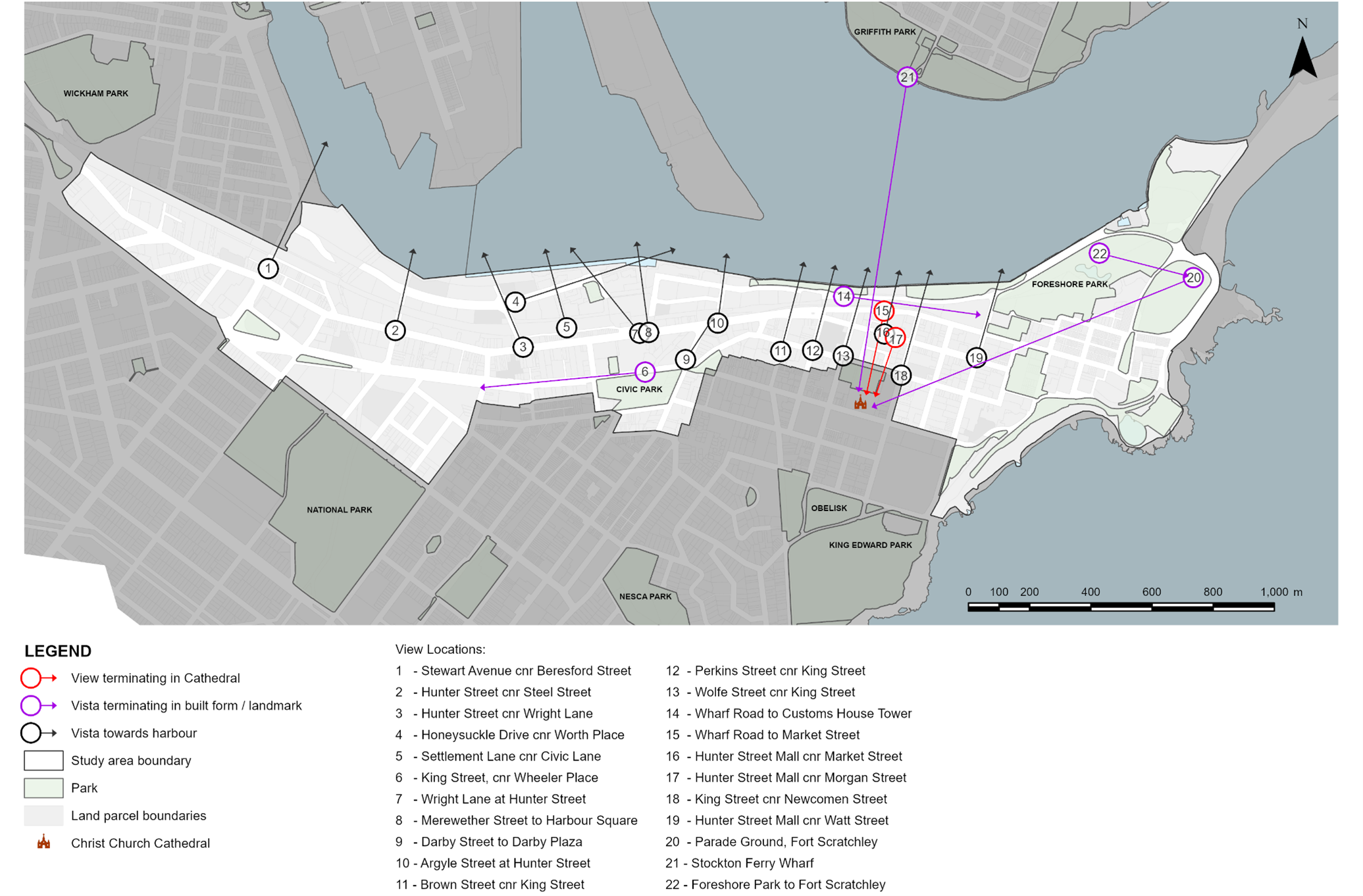 Figure E5.13: Views and vistas map Figure E5.13: Views and vistas map | ||
PC-2. New development minimises view loss and maximises equitable view sharing.
| DC2-1. Align new development to maximise and frame view corridors between buildings, considering topography, vegetation and surrounding development. DC2-2. Where there are potential impacts on views an assessment of the following principles should be submitted with the application:
DC2-3. Where views are potentially compromised, an assessment of the view loss must be undertaken having regard to ‘Views – General Principles’ of the NSW Land and Environment Court (presently Tenacity Consulting v Warringah Council [2004] NSWLEC 140). |
|
Objectives
- Promote lot consolidation and ensure development does not result in isolated sites.
Performance criteria (PC) | Design criteria (DC) | Explanatory note(s) |
PC-1. Development:
| DC1-1. Development is not to result in the creation of an isolated site that could have been developed in compliance with the relevant planning controls. Appropriate documentary evidence to demonstrate that a genuine and reasonable attempt has been made to purchase an isolated site based on a fair market value. DC1-2. Where amalgamation of the isolated site is not feasible, applicants will be required to demonstrate that an orderly and economic use and development of the separate sites can be achieved. DC1-3. The development of existing isolated sites is not to detract from the character of the streetscape and is to achieve a satisfactory level of amenity including solar access, visual and acoustic privacy. Development of existing isolated sites may not achieve the maximum potential, particularly height and floor space ratio, and will be assessed on merit. DC1-4. Where adjacent sites are developing concurrently, site planning options for development as an amalgamated site are to be explored. | Reasonable offers to purchase a site that is to be isolated are to be made at an early stage prior to DA lodgement. However, where an applicant has failed to negotiate before a DA was lodged, it is not necessarily too late to do so after lodgement. Documentation is required to demonstrate in writing that an offer to purchase has been made to the owner(s) of the isolated lot and the owner has refused to negotiate. A licensed valuer must base the offer on at least one recent independent valuation. Development that would result in the creation of an isolated lot must comply with the planning principles established by the Land and Environment Court in Melissa Grech v Auburn Council [2004] NSWLEC 40, Cornerstone Property Group Pty Ltd v Warringah Council [2004] NSWLEC 189; Karavellas v Sutherland Shire Council [2004] NSWLEC 251; provide for a future extension incorporating the isolated lot, or demonstrate that the isolated lot can be developed independently. |
Activation of the city centre is achieved by providing inviting streets and places that encourage free movement, social interaction and business activity. Addressing the street relates to how development contributes to an engaging, comfortable and safe public realm. The relationship between a building and the street edge determines how accessible and functional a building is. All development adjoining the public domain needs to be well designed, using high quality durable materials.
Active street frontages promote an interesting and safe pedestrian environment. Shops, studios, offices, cafes, recreation and community facilities provide the most active street fronts. Residential buildings can contribute positively to the street by providing a clear street address, direct access from the street and outlook over the street.
Objectives
- Ensure that ground floor uses contribute to the liveliness and vitality of the street, creating a positive and active environment.
- Ensure that buildings are designed and oriented to positively address streets, footpaths, lanes and other public spaces to promote vitality, interaction, and casual surveillance, concentrate and reinforce pedestrian activity, and provide visual interest to the street frontage.
- Ensure that ground levels are designed to mitigate flood risk while maintaining accessibility and a positive relationship with the public domain.
Performance criteria (PC) | Design criteria (DC) | Explanatory note(s) |
PC-1. Ground floor uses add to the liveliness, safety and vitality of the street. | DC1-1. A minimum of 70% of a building’s primary frontage is to be an ‘active frontage’. DC1-2. Active frontages are to be provided on secondary frontages, laneways, through-site links and arcades where practicable. DC1-3. Clear glazing is to be provided to windows and doors. DC1-4. Fire escapes, service doors, substations, car park entries and plant and equipment hatches and grilles, to the street frontage shall be minimised. DC1-5. Ground levels of buildings in commercial core and mixed zones have a minimum 4m floor to ceiling height on the ground floor to ensure flexibility for a variety of active uses. DC1-6. Foyer and lobby spaces are no more than 20% of the street frontage. DC1-7. Shopfronts are enclosed, unless they are food and drink premises. DC1-8. Residential ground floor units are to have individual gates and entrances accessed directly from the street. DC1-9. Ground floor residential apartments are to be elevated from the street level by a minimum of 300mm and a maximum of 600mm unless this results in being below flood levels. DC1-10. Ground floor residential fences are to be no more than 1.2m in height with a minimum 50% transparency. Soft landscaping is encouraged. Colourbond must be avoided. DC1-11. Signage, decals and posters on windows on the ground floor are not to cover more than 15% of a window. | An ‘active frontage’ is one with transparent glazing to allow unobstructed views from the adjacent footpath to at least a depth of 6m within the building. Street frontages may most effectively be activated through one or more of the following:
|
PC-2. Buildings are designed and oriented to positively address streets, footpaths, lanes and other public spaces to:
| DC2-1. Development is to avoid blank walls that inhibit natural surveillance and encourage graffiti. DC2-2. Building design shall avoid creating opportunities for personal concealment. DC2-3. Building entrances and shelter from the elements should be provided within recesses behind the building line rather than under porte-cochères. DC2-4. Security grills, where provided, are fitted internally behind the shop front, are fully retractable and at least 50% transparent when closed. DC2-5. Ground floor retail premises and business premises are to integrate lighting and building illumination to improve street presence and safety during the night |
|
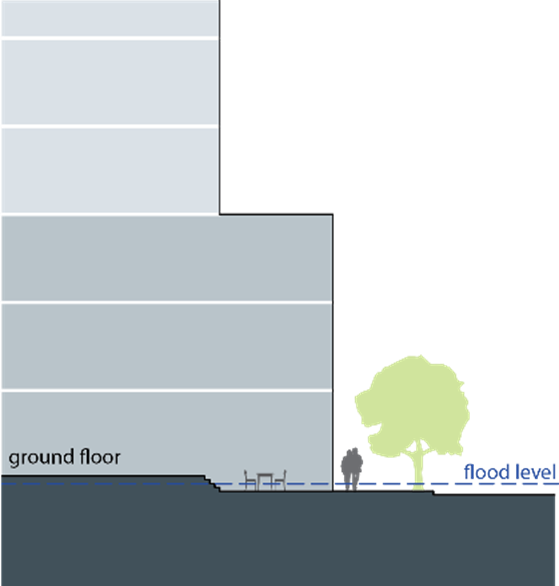
PC-3. Ground levels are designed to mitigate flood risk while ensuring accessibility and a positive relationship to the public domain. | DC3-1. The ground floor level will be built to the same level as the footpath where the lowest level is above the flood planning level. DC3-2. Where the footpath is below the flood planning level, accessibility ramps should be located from the footpath to the lowest level of buildings above the flood planning level so that a positive address to the street and activated frontages are maintained. DC3-3. Where the footpath is below the flood planning level, the rise in floor level may occur within the build line to allow for dining spaces or the display of goods at footpath level as illustrated in Figure E5.14. DC3-4. Suitability of land uses at ground level should have regard to the sensitivity to flooding impacts and the ability to meet flood control requirements. DC3.5. Service elements such as sub-stations are to be designed and built to the flood planning level. |
|
Publicly accessible art is a defining quality of dynamic, interesting and successful cities. It can improve the liveability of neighbourhoods, encourage a vibrancy of the public realm and strengthen a ‘sense of place’.
Publicly accessible art can be integrated with building facades and infrastructure such as stormwater treatment and water collection, retaining walls or aboveground car park screening.
Publicly accessible art should be appropriately designed to provide a diverse range of themes and mediums to improve the identity and amenity of places. It should be safe, durable, identifiable and intuitive.
Objectives
- Incorporate publicly accessible art into significant development to enhance the sense of place and cultural identity.
- Ensure that publicly accessible art is located in appropriate areas to optimise recognition, amenity, and safety.
- Utilise publicly accessible artworks to interpret heritage components, recognise former uses of large development sites, and reflect the desired contemporary character of a place.
- Recognise and celebrate indigenous and non-indigenous cultural heritage.
- Ensure publicly accessible artwork is easy to maintain.
Performance criteria (PC) | Design criteria (DC) | Explanatory note(s) |
PC-1. Significant development incorporates publicly accessible art to strengthen a ‘sense of place’. | DC1-1. Key development sites as identified within the Newcastle Local Environment Plan 2012 (LEP 2012), as well as development over 45m in height or resulting in greater than 10,000m2 of additional gross floor area or development valued over $5 million must contribute art that is publicly accessible. DC1-2. Development required to provide publicly accessible art (in accordance with DC1.1) must be accompanied by a public art strategy prepared by a suitably qualified person. The public art strategy is to be in accordance with any strategy / guideline that outlines CN and the Public Art Reference Group's (PARG) process and expectations. Confirmation on the provision of publicly accessible art is required from CN in conjunction with the PARG or similar committee). DC1-3. The inclusion of publicly accessible art should be considered early in the design process to enable the appropriate integration of art with the detailed fabric and form of architectural, place and landscape designs. Early consultation with CN and affiliated PARG (or similar committee) is recommended. | Publicly accessible means the ability to be viewed or experienced from publicly accessible places. This may be within the building façade or within the front setback. Early discussions with CN staff on the design and placement of public art is encouraged. Publicly accessible art should be designed by local artists or a if not possible a collaborative approach is considered where an out of town artist collaborates with a local artist. The cost of publicly accessible art installations is to be 1% of the cost of construction of the development. |
PC-2. Publicly accessible art is appropriately located to maximise artwork recognition, amenity and safety. | DC2-1. Publicly accessible art should be readily visible from the street. DC2-2. Where publicly accessible art is incorporated into building facades, roof features, open spaces, walkways, building foyers, landscaping or infrastructure it should be easily recognisable as an artistic feature and labelled accordingly in a close and noticeable location. DC2-3. Publicly accessible art installations in laneways are encouraged, including creative lighting to activate the laneway at night. DC2-4. The artwork should not be climbable unless specifically designed as a play safe artwork. |
|
PC-3. Publicly accessible artworks are used to interpret heritage components or recognise former uses of large development sites or the desired contemporary character of a place. | DC3-1. Applicants should work with a heritage consultant and/or a public artist to develop innovative ways to interpret heritage using publicly accessible art. DC3-2. Publicly accessible art should respond to the significance and character of the location and where appropriate, interpret indigenous and non-indigenous cultural heritage. DC3-3. Publicly accessible art should cover a diverse range of themes and mediums to provide visual amenity and encourage interaction. DC3-4. Publicly accessible art must be safe and durable with consideration to avoid sharp edges, protrusions at eye height, trip hazards, and prevention of vandalism and deterioration over time. | Refer to Section E2 Heritage conservation areas. |
PC-4. Publicly accessible artwork is easy to maintain | DC4-1. A publicly accessible artwork maintenance plan is developed prior to the installation of each new publicly accessible artwork to ensure the effective management of artwork. DC4-2. Where art is permanent, use materials that are:
|
|
Good solar access is a key contributor to the amenity of public spaces, particularly during winter. Solar access in public spaces is becoming more important as more people move into apartments in the city centre. Good solar access ensures that public spaces such as squares and parks are inviting and well utilised. This sub-section should be read in conjunction with sub-section 7.0 Building setbacks and separation and sub-sections 21.0 to 29.0 Character Areas and Key Precincts (where applicable).
Objectives
- Ensure that public spaces receive adequate access to sunlight to promote their usability, safety and comfort for users.
Performance criteria (PC) | Design criteria (DC) | Explanatory note(s) |
PC-1. Solar access to public spaces is to be maximised.
| DC1-1. Solar access is provided to 50% of significant public spaces for at least 2 hours during mid-winter between 9am and 3pm, with at least 1 hour of lunchtime sun access to be provided between 12 noon and 2pm (unless otherwise specified in Character Areas and Key Precincts). DC1-2. Should the existing level of solar access to a significant public space be currently less than 50%, development shall not reduce direct solar light access to the space any further. DC1-3. Development must consider the cumulative reduction of solar access to the public domain including potential future development on surrounding sites. | Significant public spaces in the city centre include:
|
The Newcastle city centre consists of eight distinct ‘Character Areas’, each with their own distinct character, created by their setting, geography, heritage, built form and functions. Consideration for these elements and implementation of an appropriate design response represents an opportunity for the ongoing renewal and revitalisation of the city centre in line with the desired future character.
Within some Character Areas are ‘Key Precincts’ that have particular significance and for which place-specific layout and design elements are identified.
The Newcastle city centre Character Areas and Key Precincts are identified in Figure E5.15.
Performance criteria (PC) | Design criteria (DC) | Explanatory note(s) |
PC-1. New development supports and enhances the identified future character and sense of place specific to its location. | DC1-1. Applications for new development are to provide a statement addressing how it will achieve consistency with the Desired Character Statement of the relevant Character Area and Key Precinct as outlined in this subsection. The statement will address, but not be limited to the following considerations:
DC1-2. Development is consistent with the Newcastle Cultural Precinct Concept Master Plan. | The Newcastle city centre encompasses part or all of the ‘C1 Cooks Hill’, ‘C4 Newcastle City Centre’, ‘C5 Newcastle East’ and ‘C6 The Hill’ Heritage Conservation Areas under Schedule 5 of LEP 2012. Accordingly, this section is to be read in conjunction with Section E1 Built and landscape heritage and Section E2 Heritage conservation areas. The Newcastle Cultural Precinct Concept Master Plan provides a range of key moves for the city centre. New development must demonstrate consistency with the master plan. |
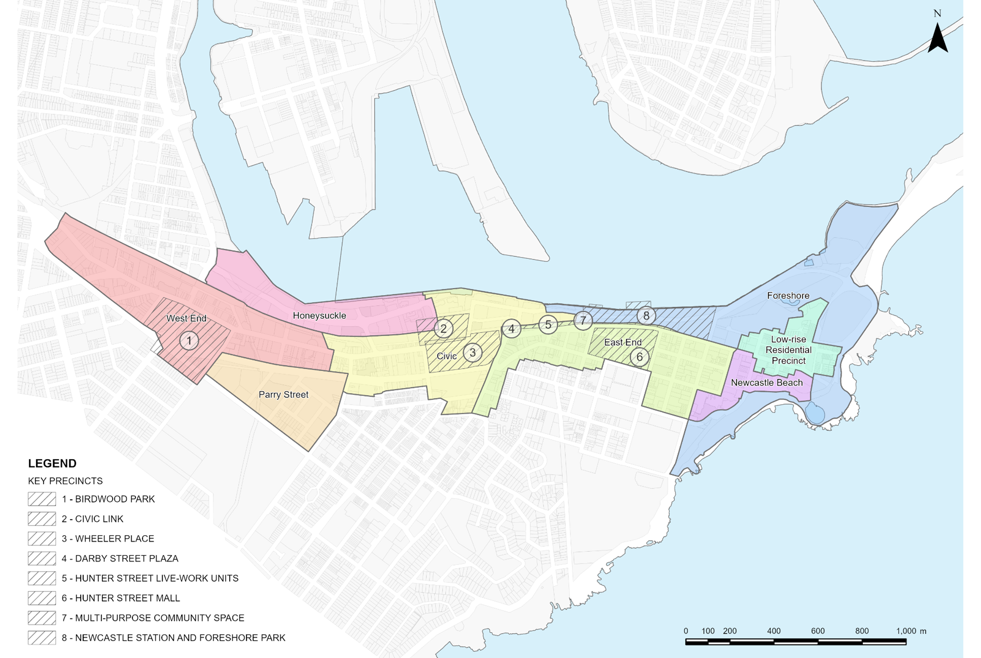 Figure E5.15: Newcastle city centre character areas Figure E5.15: Newcastle city centre character areas | ||
Desired character statement The West End Character Area and Birdwood Park key precinct are identified in Figure E5.16. This is the Western gateway to Newcastle's city centre with a discernible commercial character juxtaposed to the low-rise development adjacent in Hamilton East. The area has a varied and distinguishable skyline. Building footprints and landscaping is built to a larger scale (not necessarily higher density) compared to the rest of the city centre, utilising larger consolidated lots. West End is branded by high quality and robust materials and finishes, adding texture and interest to its contemporary built form. The area is fast-paced, vibrant and around-the-clock with large volumes of people moving between employment, hospitality, the Newcastle Interchange and interwoven residential and mixed-use developments. Home to the city’s live music scene, new development is built to encourage a safe and diverse night time atmosphere. West End is serviced by landmark high quality public spaces with the flexibility to be utilised by a great variety of user groups. Birdwood Park Key Precinct The Birdwood Park precinct affords a strong sense of arrival with well-formed blocks around the central parkland. Grand fig trees and the expansive 19th century facades of the former Castlemaine Brewery peaceably sit against adjacent modern structures. Birdwood Park is celebrated as a key recreation space in the city, with high quality and visually varied facades that enhance the outlook from the public domain and local streets. Adaptive re-use of historic buildings accentuates the variety and fine grain character in this precinct. |
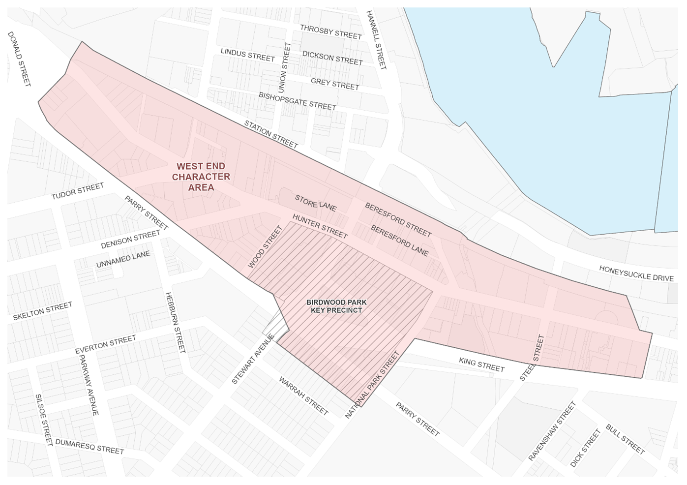 Figure E5.16: West End character area and Birdwood Park key precinct Figure E5.16: West End character area and Birdwood Park key precinct |
| Note: The West End Character Area is in the Newcastle City Centre Heritage Conservation Area, which is identified in Schedule 5 of LEP 2012. A Summary Statement of Heritage Significance and Desired Future Character is provided in Section E2 Heritage conservation areas. |
Performance criteria (PC) | Design criteria (DC) | Explanatory note(s) |
PC-1. Development supports the vision articulated in the character statement to deliver an active commercial core. | DC1-1. New development is characterised by large floorplates which have an articulated building form to reduce visual bulk and building massing. |
|
PC-2. New development that contributes to the night time economy of West End is encouraged. |
|
|
PC-3. Heritage items and contributory buildings and their setting are protected and conserved, including the Aboriginal cultural heritage and non-Aboriginal archaeology. | DC3-1. Development shall be consistent with Section E1 Built and landscape heritage and Section E2 Heritage conservation areas. DC3-2. Distinctive early industrial, warehouse and retail buildings that contribute to the character of the area are retained and re-purposed. DC3-3. Heritage items and contributory buildings are retained and adaptively re-used where suitable. DC3-4. Building form integrates with existing heritage character and echoes historic design elements. | Heritage items are identified under Schedule 5 of LEP 2012. Contributory buildings are identified in the Contributory Buildings Maps in the Newcastle Heritage Technical Manual. Refer to Section B4 Aboriginal Cultural Heritage and Section B5 Historical Archaeology. |
PC-4. A permeable street network with well-connected easily accessible streets and lanes is promoted, where pedestrian, bicycle and public transport users are prioritised over private vehicles. | DC4-1. Improved and new pedestrian connections and laneways are to be provided in accordance with Figure E5.17 and Figure E5.18 and the City Centre Public Domain Technical Manual. DC4-2. Publicly accessible spaces and connections are created or upgraded to provide high amenity and improved permeability with better connections to the river foreshore, public open space and Hamilton TAFE. DC4-3. Development is consistent with the Newcastle Cultural Precinct Concept Master Plan. |
|
PC-5. Street wall heights and ground level setbacks complement heritage buildings and contributory items whilst reinforcing the desired future commercial character of West End. | DC5-1. The street wall height of new buildings or alterations and additions to existing buildings shall be in accordance with Figure E5.17 and Figure E5.18 or as per Section E5, Part A. In the event of any inconsistency, the street wall heights in Figure E5.17 and Figure E5.18 will prevail. DC5-2. The ground floor shall be built to the street frontage unless specified otherwise in Figure E5.17 and Figure E5.18. Where a setback is provided, it may contain pedestrian areas, steps, ramps, landscape features and the like but should not contain utility structures or barriers that restrict visual permeability or pedestrian movement. | Heritage items are identified under Schedule 5 of LEP 2012. Contributory buildings are identified in the Contributory Buildings Maps in the Newcastle Heritage Technical Manual. |
PC-6. In identified activity hubs, ground floor uses add to the liveliness and vitality of the street. | DC6-1. Active frontages are to be provided in accordance with Figure E5.17 and Figure E5.18 on through-site links and pedestrian oriented lanes. |
|
PC-7. Servicing and access minimises conflicts with pedestrians. | DC7-1. Service deliveries are not to be made from Hunter Street or Stewart Avenue for development which has access to another street frontage. DC7-2. For development that has no other frontage than Hunter Street, hours for service deliveries are restricted to minimise potential conflicts with other activities. DC7-3. Vehicle access and servicing is located to minimise conflicts with pedestrians. DC7-4. Loading docks and their access points are not permitted on Hunter Street. |
|
PC-8. Public space is improved to meet the demands of the future CBD. | DC8-1. Interfaces to the public domain are carefully considered to improve amenity and access. DC8-2. Development around the Interchange, along the former rail corridor, Cottage Creek, lanes or through-site links provide a building address to encourage activity, pedestrian and cycleway movement, and improve safety. DC8-3. Public domain improvements are in accordance with any adopted Public Domain Plan and the City Centre Technical Manual of CN. |
|
PC-9. Birdwood Park is utilised as a landmark public open space. | DC9-1. Development in the Birdwood Park Key Precinct shall be in accordance with Figure E5.18. DC9-2. New development fronting Birdwood Park addresses the park edge and promotes a sense of enclosure by being built to the street alignment. DC9-3. New development minimises additional overshadowing of Birdwood Park and complies with the design criteria in as per sub-section 20.0. DC9-4. King Street, along Birdwood Park, is to be reshaped as a shared pedestrian and vehicular street and a place of pedestrian activity by:
|
|
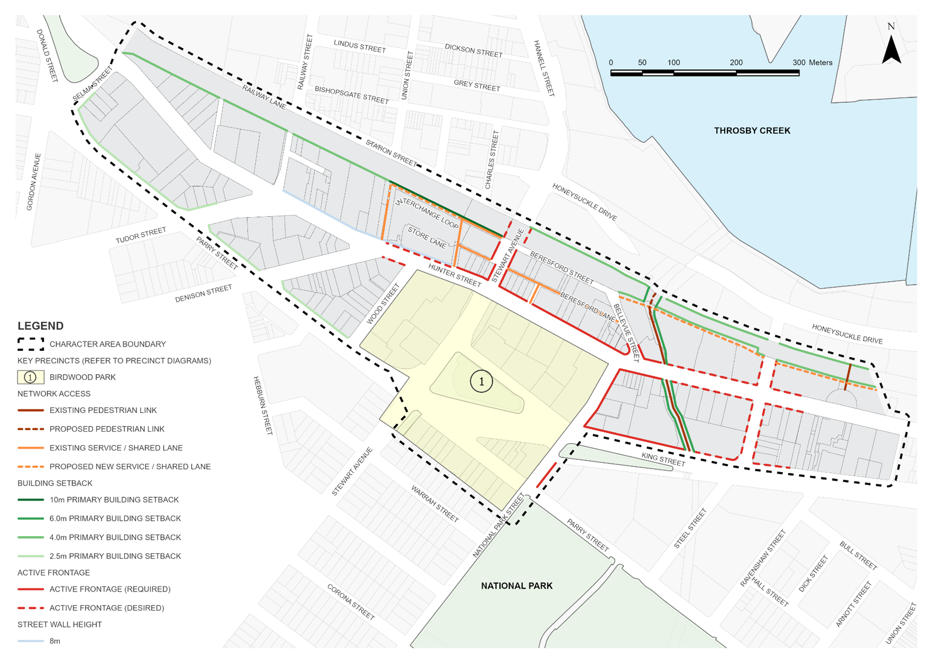 Figure E5.17: West End character area & and Birdwood Park key precinct map Figure E5.17: West End character area & and Birdwood Park key precinct map | ||
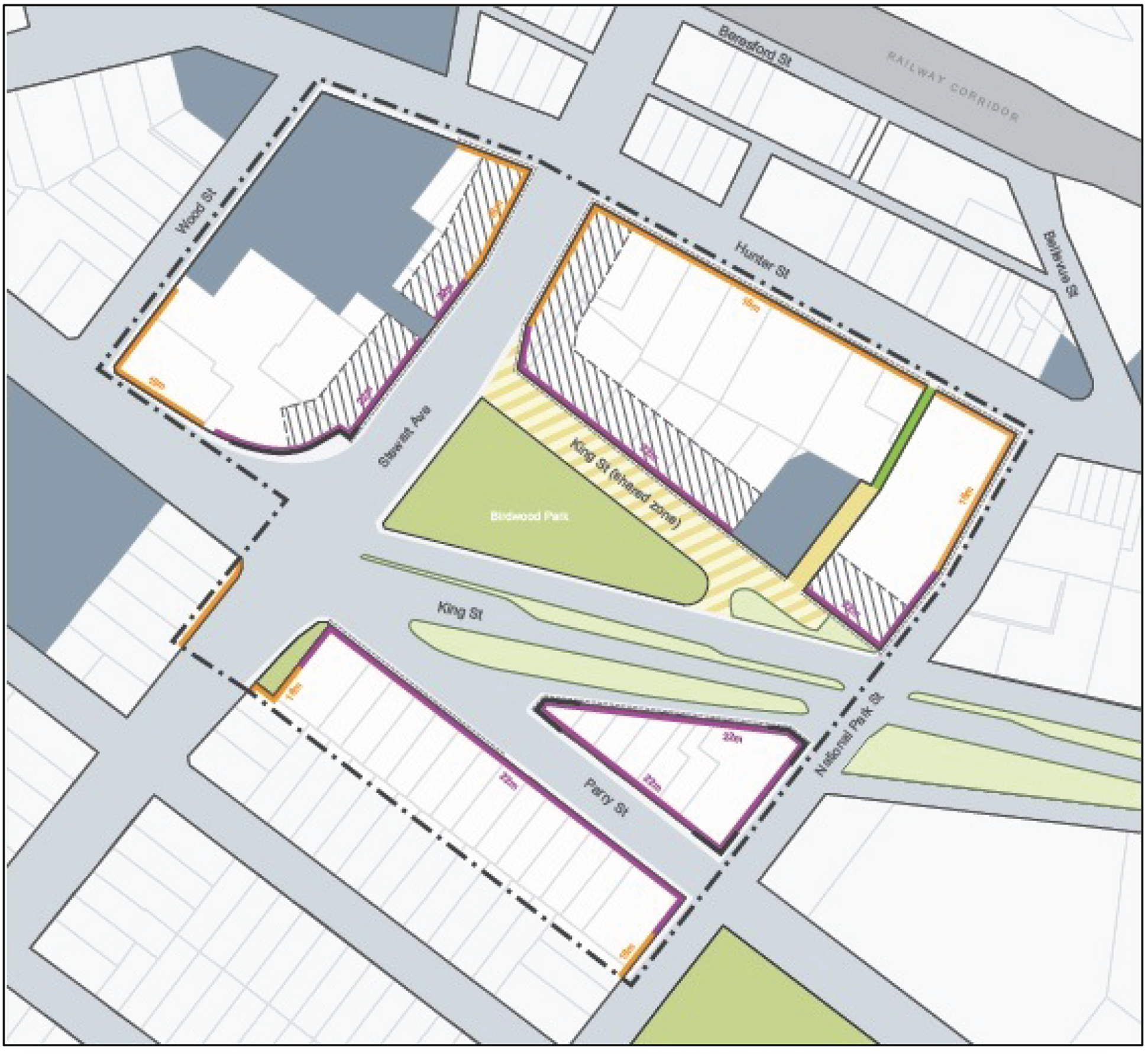 Figure E5.18: Birdwood Park key precinct map Figure E5.18: Birdwood Park key precinct map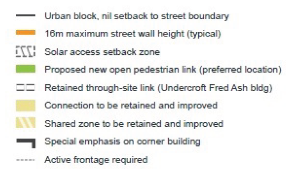 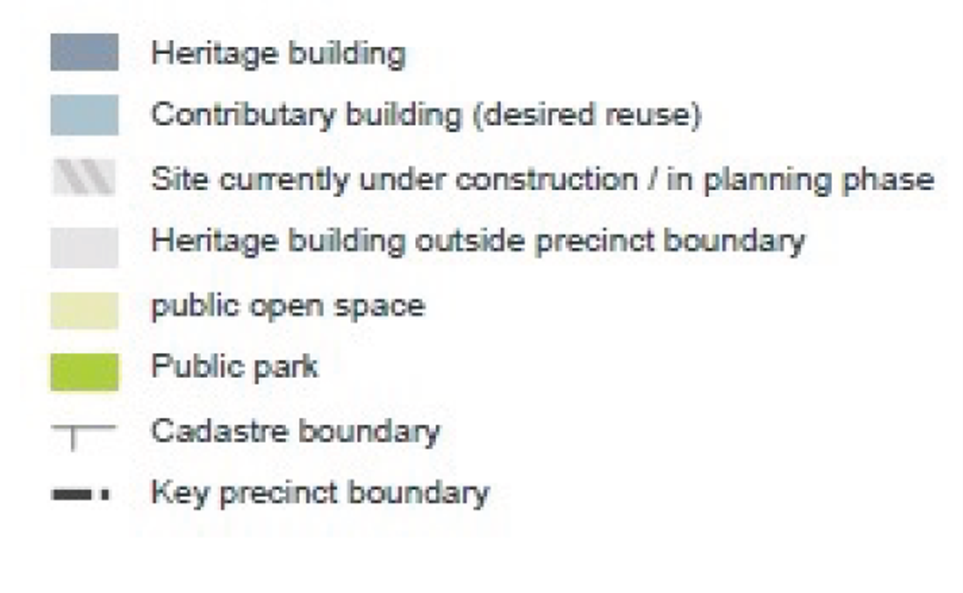 | ||
Desired character statement The Honeysuckle Character Area identified in Figure E5.19 is a modern transit-orientated district hosting businesses, up-market penthouse apartments and hotels. Long boulevard streets and laneways bustle with popular restaurants, cafes and bars. The area is renowned for high quality landscaping and public art. Windows and balconies watch over the wide promenade which provides a human corridor right around the City Centre peninsula. An integrated network of inviting, safe and inclusive paths, streets and open corridors draw breezes, views and people to and from the waterfront and the spine of the city. Refer to sub-section 24. Civic for control for the Civic Link Key Precinct. | 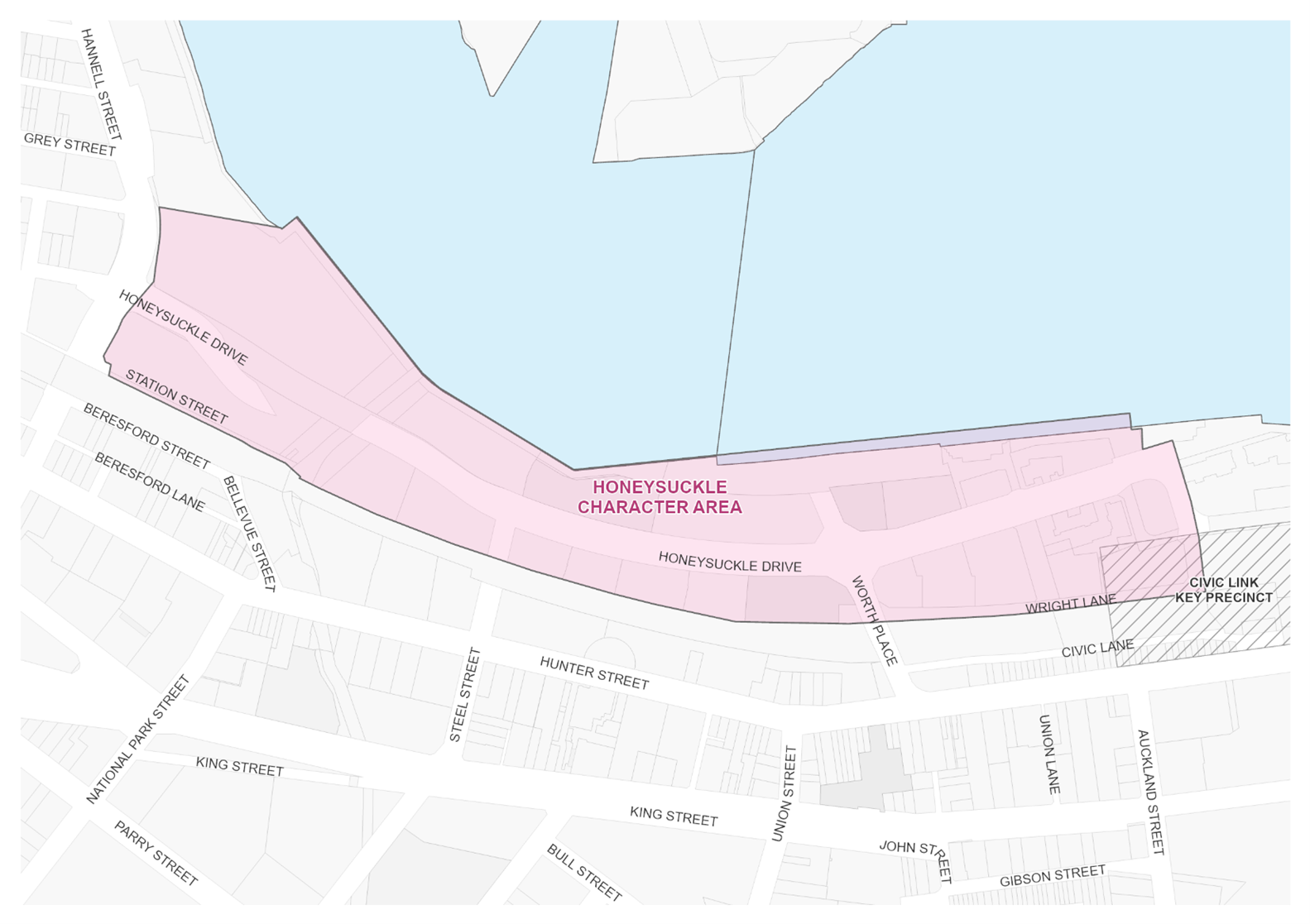 Figure E5.19: Honeysuckle character area map Figure E5.19: Honeysuckle character area map |
| Note: Part of the Honeysuckle Character Area is in the Newcastle City Centre Heritage Conservation Area. The Newcastle City Centre Heritage Conservation Area is identified under Schedule 5 of LEP 2012. A Summary Statement of Heritage Significance and Desired Future Character is provided in Section E2 Heritage conservation areas. |
Performance criteria (PC) | Design criteria (DC) | Explanatory note(s) |
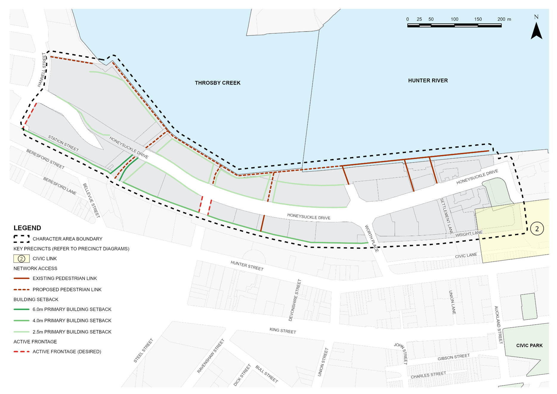
PC-1. The foreshore and surrounding access network is activated. | DC1-1. Development between the former rail corridor and Honeysuckle Drive will provide a building address to both frontages. DC1-2. Development along the waterfront, Cottage Creek, lanes or through-site links will provide a building address to encourage activity, pedestrian and cycleway movement, and improve safety. | |
PC-2. Heritage items and contributory buildings and their setting are protected and conserved, including the Aboriginal cultural heritage and non-Aboriginal archaeology. | DC2-1. Development shall be consistent with Section E1 Built landscape heritage and Section E2 Heritage conservation areas. DC2-2. Heritage items and contributory buildings are retained and adaptively re-used where suitable. | Heritage items are identified under Schedule 5 of LEP 2012. Contributory buildings are identified in the Contributory Buildings Maps in the Newcastle Heritage Technical Manual. Refer to Section B4 Aboriginal Cultural Heritage and Section B5 Historical Archaeology. |
PC-3. A permeable street network with well-connected easily accessible streets and lanes is promoted, where pedestrian, bicycle and public transport users are prioritised over private vehicles. | DC3-1. Improved and new pedestrian connections and laneways are to be provided in accordance with Figure E5.20 and the City Centre Public Domain Technical Manual. |
|
PC-4. Street wall heights and ground level setbacks provide a consistent street edge. | DC4-1. The street wall height of new buildings or alterations and additions to existing buildings shall be in accordance with Figure E5.20 or as per sub-section 6.0. In the event of any inconsistency, the street wall heights in Figure E5.20 will prevail. DC4-2. The ground floor shall be built to the street frontage unless specified otherwise in accordance with Figure E5.20. Where a setback is provided, it may contain pedestrian areas, steps, ramps, landscape features and the like but should not contain utility structures or barriers that restrict visual permeability or pedestrian movement. |
|
PC-5. In identified activity hubs, ground floor uses add to the liveliness and vitality of the street. | DC5-1. Active frontages are to be provided in accordance with Figure E5.20 on through-site links and pedestrian oriented lanes. |
|
| ||
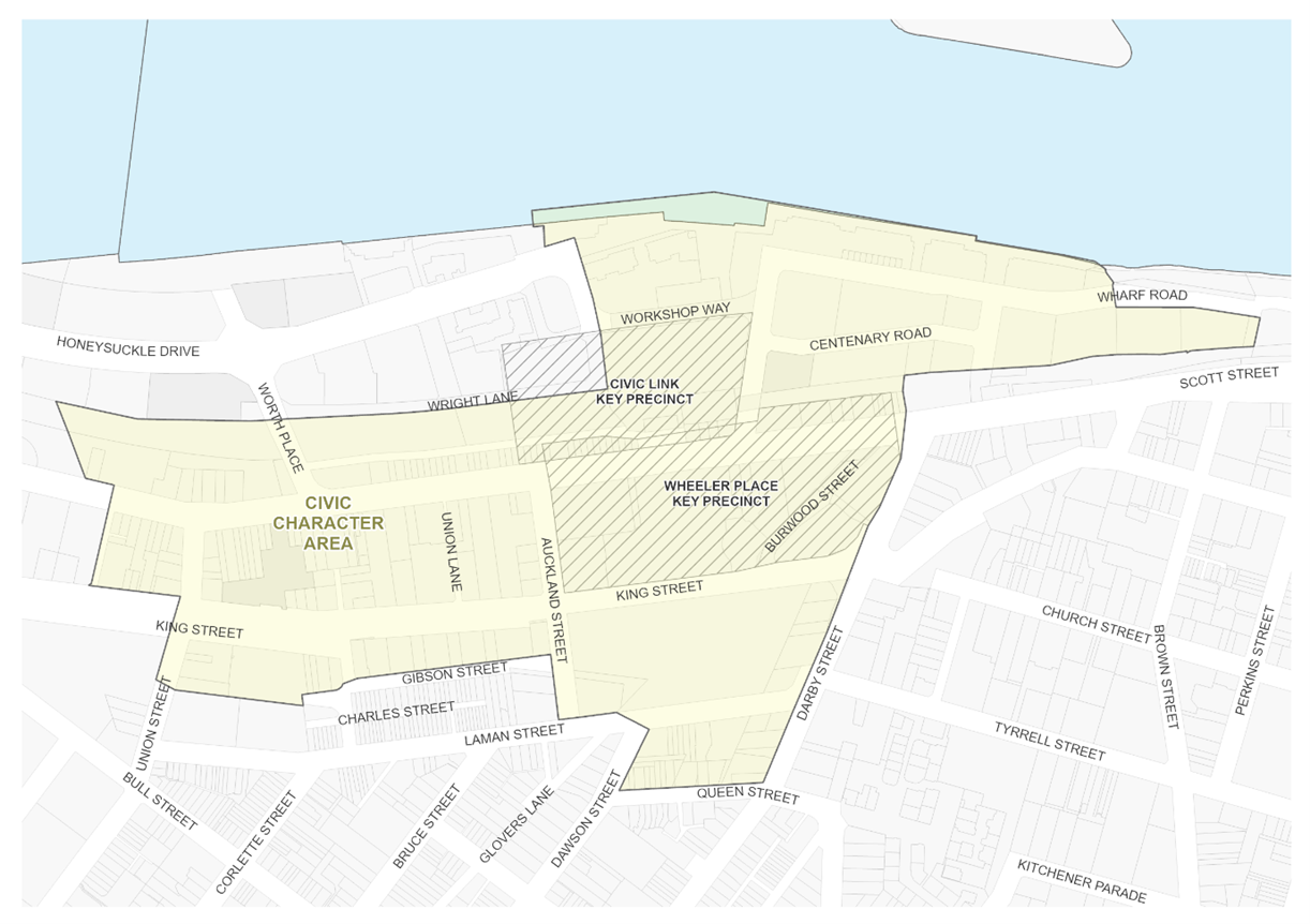
Desired character statement The Civic Character Area and Key Precincts identified in Figure E5.21 express the city’s regional significance with the visual prominence of grand architecture and public domain such as the Newcastle Museum, Newcastle Art Gallery, Newcastle City Library, Newcastle City Hall, Wheeler Place and Civic Theatre. An administrative, cultural and educational district has been created around large institutions such as the University of Newcastle and the Newcastle Court House which are supported by smaller commercial spaces of legal support services and housing and retail servicing the needs of students. At the geographic heart of the city’s nightlife, the area continues to offer a diversity in cultural and entertainment options that continue into the evening. Wheeler Place Key Precinct Wheeler Place is the ‘town square’ of Newcastle and anchors a sense of civic importance with direct visual and pedestrian linkages to Newcastle Museum and the foreshore, Newcastle University, Civic Park and Darby Street. Civic Arcade is active with students accessing major new education facilities in this location. Civic Link Key Precinct The precinct provides popular open space, walking and cycling connections that link many of the region’s key civic and cultural assets (including Civic Park, City Hall, Civic Theatre, Newcastle Museum) to the foreshore and light rail system. It provides a civic focused public space with direct visual and physical connection from Wheeler Place to the harbour and is an asset for adjacent development providing recreational space for the needs of the growing population. Darby Plaza Key Precinct Darby Plaza forms a community focused public space, providing a pedestrian and cycle connection from Darby Street - Newcastle’s primary cafe and dining – across Hunter Street to the harbour. |
|
Performance criteria (PC) | Design criteria (DC) | Explanatory note(s) |
PC-1. Support the administrative presence and regional significance of the city | DC1-1. Pedestrian connections between the city’s cultural buildings and spaces and to the foreshore are reinforced. DC1-2. Provide visual and physical connections through the Area to the Hunter River foreshore. |
|
PC-2. Heritage items and contributory buildings and their setting are protected and conserved, including the Aboriginal cultural heritage and non-Aboriginal archaeology. | DC2-1. Development shall be consistent with Section E1 Built landscape heritage and Section E2 Heritage conservation areas. DC2-2. Distinctive early industrial, warehouse and retail buildings that contribute to the character of the area are retained and re-purposed. DC2-3. Heritage items and contributory buildings are retained and adaptively re-used where suitable. DC2-4. Building form integrates with existing heritage character and echoes historic design elements. | Heritage items are identified under Schedule 5 of LEP 2012. Contributory buildings are identified in the Contributory Buildings Maps in the Newcastle Heritage Technical Manual. Refer to Section B4 Aboriginal Cultural Heritage and Section B5 Historical Archaeology. |
PC-3. A permeable street network with well-connected easily accessible streets and lanes is promoted, where pedestrian, bicycle and public transport users are prioritised over private vehicles. | DC3-1. Improved and new pedestrian connections and laneways are to be provided in accordance with Figure E5.22 and the City Centre Public Domain Technical Manual. |
|
PC-4. Street wall heights and ground level setbacks complement heritage buildings and contributory items whilst reinforcing the desired future character of Civic. | DC4-1. The street wall height of new buildings or alterations and additions to existing buildings shall be in accordance with Figure E5.22 or as per subsection 6.0. In the event of any inconsistency, the street wall heights in Figure E5.22 will prevail. DC4-2. The ground floor shall be built to the street frontage unless specified otherwise in Figure E5.22, Figure E5.23, Figure E5.24 and Figure E5.28. Where a setback is provided, it may contain pedestrian areas, steps, ramps, landscape features and the like but should not contain utility structures or barriers that restrict visual permeability or pedestrian movement. | Heritage items are identified under Schedule 5 of LEP 2012. Contributory buildings are identified in the Contributory Buildings Maps in the Newcastle Heritage Technical Manual. |
PC-5. In identified activity hubs, ground floor uses add to the liveliness and vitality of the street. | DC5-1. Active frontages are to be provided in accordance with Figure E5.22, on through-site links and pedestrian oriented lanes. DC5-2. New development between the former rail corridor and Hunter Street will provide building addresses to both frontages. DC 5-3. Improve and expand public open space in the heart of Civic to complement and enhance Wheeler Place. DC5-4. Development along publicly accessible spaces, lanes or through-site links will provide a building address to encourage activity, pedestrian and cycleway movement, and improve safety. DC5-5. New development protects sunlight access to the footpath on the south side of Hunter Street and to Wheeler Place, Civic Link, Civic Park and Christie Place between 12 noon and 2pm at midwinter and complies with the design criteria in sub-section 20.0. |
|
PC-6. Promote Wheeler Place Key Precinct as the civic, administrative, education and cultural heart of Newcastle. | DC6-1. Development in the Wheeler Place Key Precinct shall be in accordance with Figure E5.23. DC6-2. A new through site-link or arcade from Christie Place to Hunter Street is provided. DC6-3. A new through-site link or arcade is provided from Christie Street to Auckland Street. DC6-4. New development provides an address to Christie Place with active frontages. DC6-5. New development near the corner of Hunter and Auckland Streets will have a slender form, no wider than University House (former Nesca House). DC6-6. New development will ensure the clock tower of City Hall retains its prominence. DC6-7. An appropriate curtilage, as defined by a relevant conservation management plan and/or heritage impact statement, must be provided to Civic Theatre. DC6-8. Sunlight access to Christie Place is maintained. DC6-9. The upper setback to Civic Theatre and University House (former Nesca House) will be at least 6m. |
|
|
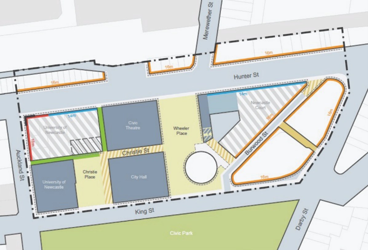 Figure E5.23: Wheeler Place key precinct map Figure E5.23: Wheeler Place key precinct map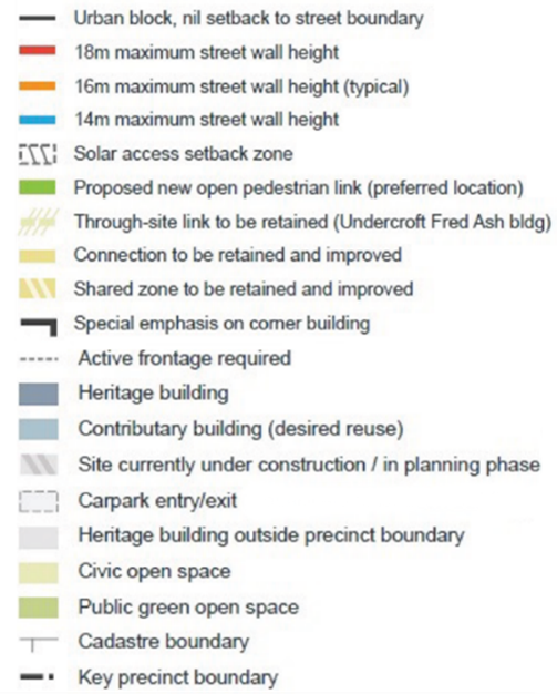 |
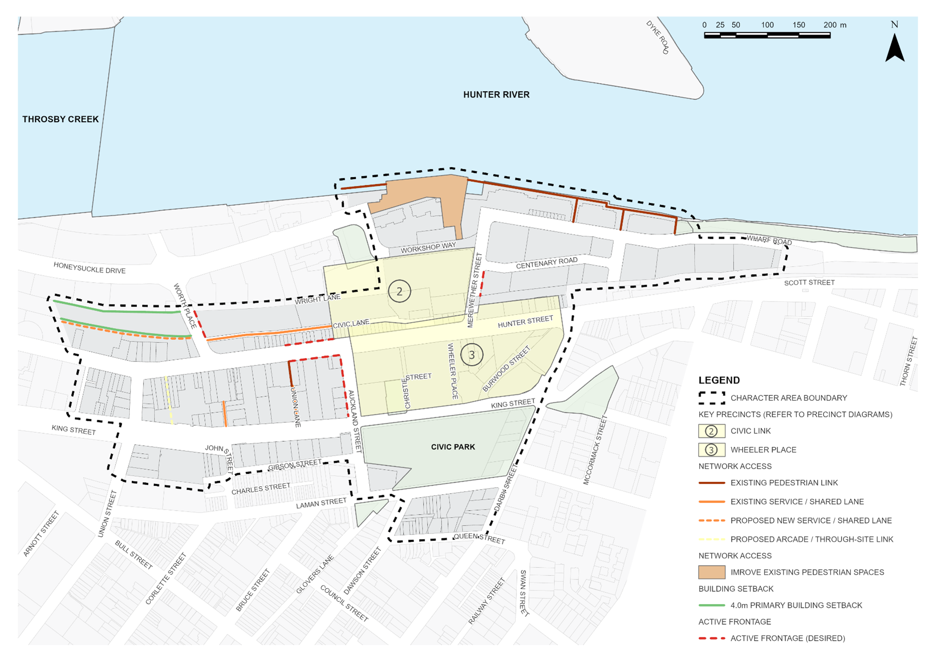
PC-7. Deliver development surrounding the new Civic Link and along Civic Lane that contributes to the realisation of the area as the civic heart of Newcastle. | DC7-1. Development in the Civic Link Key Precinct shall be in accordance with Figure: E5.24. DC7-2. Civic Lane will provide vehicular access to properties on the northern side of Hunter Street and the new developments between Civic Lane and Wright Lane. DC7-3. Civic Lane will provide one-way vehicular movement in an east to west direction with an entry via a shared way through Civic Link onto Hunter Street. DC7-4. Consolidated access points will be provided to building lots along Civic Lane to reduce the dominance of driveways. DC7-5. A minimum 1.2m wide footpath will be provided on the southern side of Civic Lane see Figure E5.25. DC7-6. Pedestrian access along the northern side of Civic Lane will be integrated within the building setback of the associated development which may be in the form of a colonnade. DC7-7. A minimum 4.5m wide pedestrian only link will be provided on the northern side of the former railway corridor between Civic Link and Merewether Street see Figure E5.26. DC7-8. A minimum 8m wide vehicular accessway will be provided adjoining the southern boundary of the former railway corridor accessed from Merewether Street see Figure E5.27. DC7-9. Vehicle access and servicing to the sites adjoining Civic Lane will be provided from Civic Lane to minimise conflicts with pedestrians. DC7-10. Service deliveries and garbage collection hours will be restricted to minimise potential conflict with pedestrians and other activities within the shared zone of the Civic Link open space. |
| |
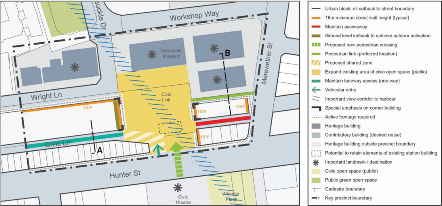 Figure E5.24: Civic link key precinct map Figure E5.24: Civic link key precinct map | |||
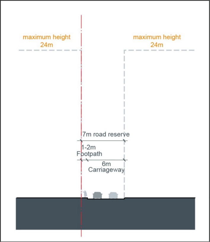 Figure E5.25: Civic lane section Figure E5.25: Civic lane section |
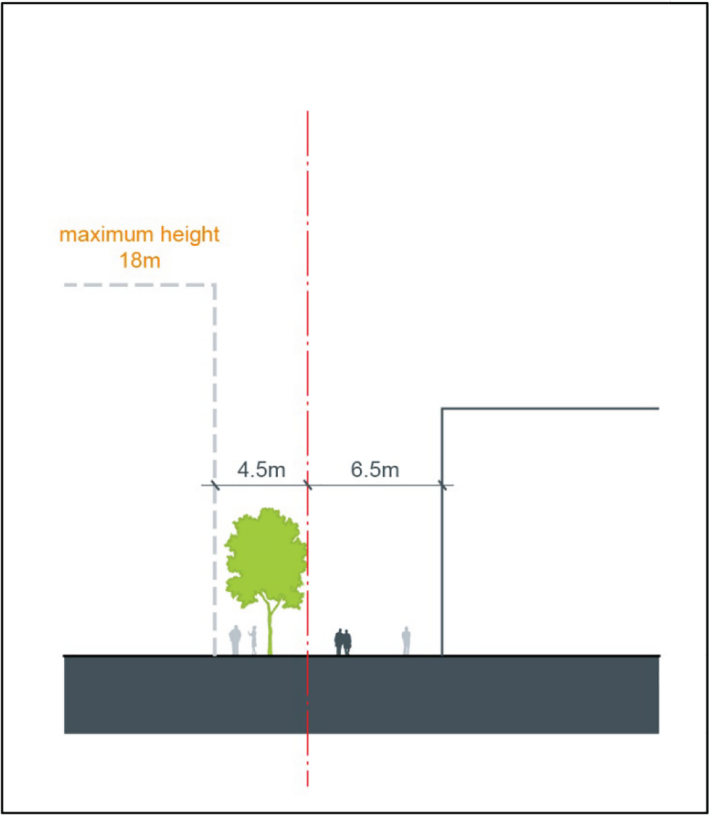 Figure E5.26: Section through new accessway way between Merewether Street and Civic Lane Figure E5.26: Section through new accessway way between Merewether Street and Civic Lane | ||
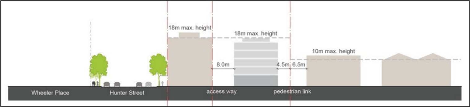 Figure E5.27: Section through the civic link key precinct (Wheeler Place to Newcastle Museum) Figure E5.27: Section through the civic link key precinct (Wheeler Place to Newcastle Museum) | |||
PC-8. The bulk of building form in the Civic Link precinct achieves good amenity for pedestrians and neighbouring buildings, and respects and integrates well with nearby heritage items and contributory buildings | DC8-1. New development is articulated so that large expanses of building form are broken down into smaller elements. DC8-2. Taller buildings are set back from Civic Link, to provide a gradual increase in scale along the former railway corridor from Civic Link to the east and from Civic Link to the west. DC8-3. Buildings facing Civic Link will include prominent architectural or design features on corners to create landmarks and points of interest. DC8-4. Buildings with a secondary frontage to a laneway will incorporate setbacks that enable ground floor active uses, vehicular access and off-street loading zones. DC8-5. A reduced setback above the street wall height of 3m may be provided within sites bounded by Civic Link and Merewether Street. | Heritage items are identified under Schedule 5 of LEP 2012. Contributory buildings are identified in the Contributory Buildings Maps in the Newcastle Heritage Technical Manual. | |
PC-9. Development supports Darby Plaza as an active mixed use precinct. | DC9-1. Development in the Darby Plaza Key Precinct shall be in accordance with Figure E5.28. DC9-2. Pedestrian permeability and amenity is improved with safe public movement provided from Darby Street and Argyle Street to the waterfront. DC9-3. Mixed use development provides active frontages to both Hunter Street and Darby Plaza with active ground floor uses and natural surveillance from floors above. DC9-4.V iew corridors and sight lines are improved from the eastern side of Darby Street and Argyle Street to enhance safety and wayfinding. DC9-5. Buildings adjoining Darby Plaza complement the view corridor through Darby Plaza. DC9-6. Buildings adjoining Darby Plaza are designed to integrate into the public open space see Figure 28. DC9-7. Vehicular access and servicing is from Argyle Street via a shared way within Darby Plaza and located so as to minimise and manage potential conflicts with pedestrians. DC9-8. Service deliveries and garbage collection hours will be restricted to minimise potential conflict with pedestrians and other activities within the Plaza. |
| |
| |||
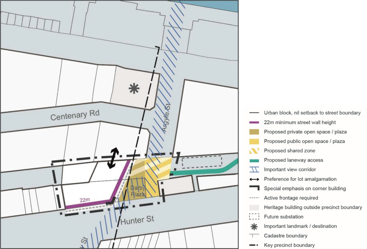
Desired character statement The Parry Street Character Area is identified in Figure E5.29 and is an urban, mixed use precinct. High quality residential development takes advantage of good amenity offered by proximity to the city centre and National Park, and available services such as retail, entertainment and employment opportunities. The area is a tight, walkable concentration of chic side-street boutiques, artisan food, cosy cafes and cosmopolitan living. The streets are articulated with visual interest, being a meeting place for a diversity of people and offering an assortment of experiences for locals and visitors alike. Future development within the precinct will continue to encourage and recognise the entertainment options available, and encourage a safe and diverse night time atmosphere. | |
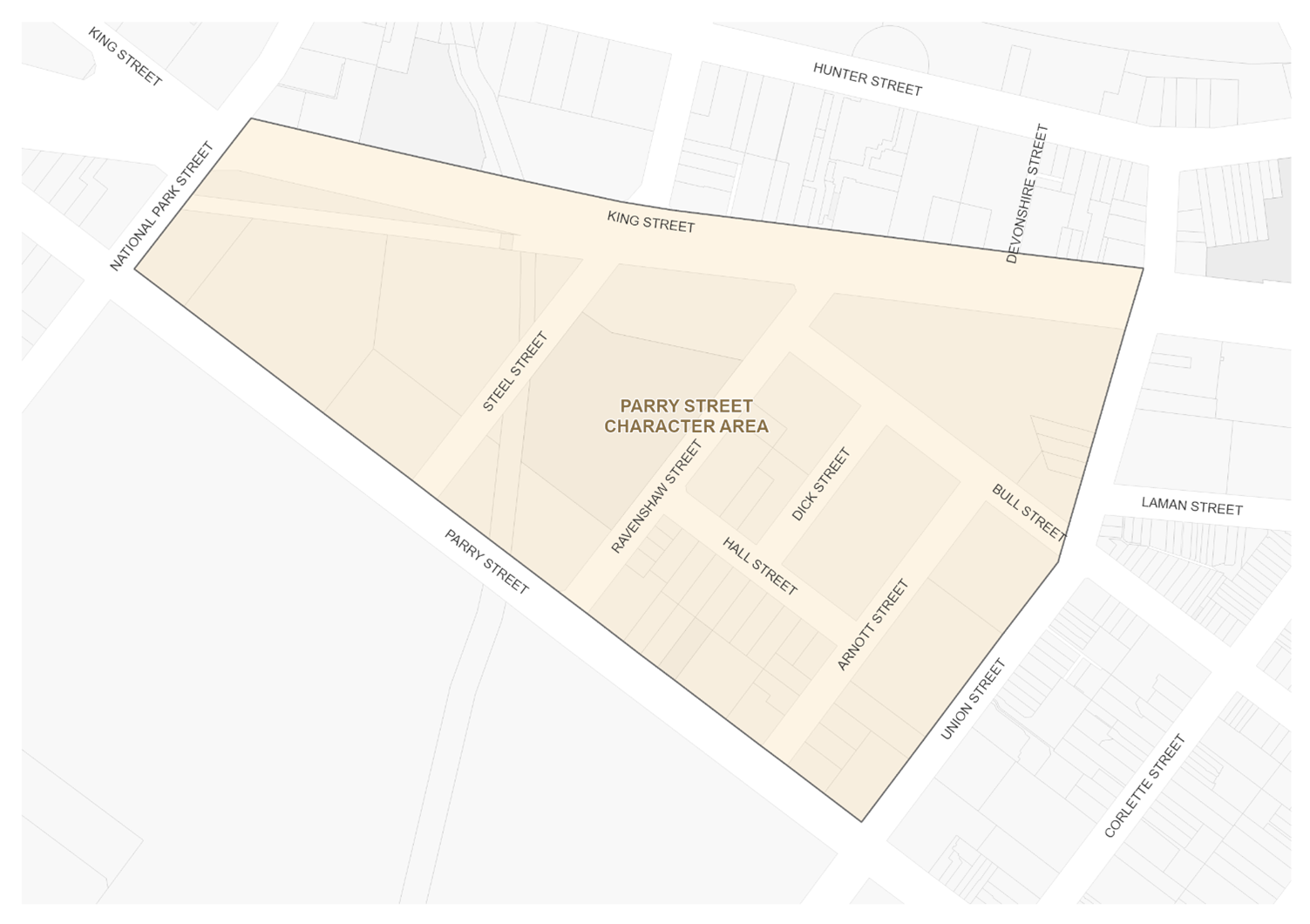
| Note: The Parry Street Character Area is in Newcastle City Centre Heritage Conservation Area that is identified under Schedule 5 of LEP 2012. A Summary Statement of Heritage Significance and Desired Future Character is provided in Section E2 Heritage conservation areas. |
Performance criteria (PC) | Design criteria (DC) | Explanatory note(s) |
PC-1. Public domain is improved to support the evolving character of the area. | DC1-1. Development adjacent to National Park will maximise visual and physical connections to the park to provide surveillance and activation across Parry Street. DC1-2. Development along Cottage Creek will provide a building address to encourage activity, pedestrian and cycleway movement, and improve safety. |
|
PC-2. Heritage items and contributory buildings and their setting are protected and conserved, including the Aboriginal cultural heritage and non-Aboriginal archaeology. | DC2-1. Development shall be consistent with Section E1 Built landscape heritage and Section E2 Heritage conservation areas. DC2-2. Distinctive early industrial, warehouse and retail buildings that contribute to the character of the area are retained and re-purposed. DC2-3. Heritage items and contributory buildings are retained and adaptively re-used where suitable. | Heritage items are identified under Schedule 5 of LEP 2012. Contributory buildings are identified in the Contributory Buildings Maps in the Newcastle Heritage Technical Manual. Refer to Section B4 Aboriginal Cultural Heritage and Section B5 Historical Archaeology. |
PC-3. A permeable street network with well-connected easily accessible streets and lanes is promoted, where pedestrian, bicycle and public transport users are prioritised over private vehicles. | DC3-1. Improved and new pedestrian connections and laneways are to be provided in accordance with Figure E5.30 and the City Centre Public Domain Technical Manual. |
|
PC-4. Street wall heights and ground level setbacks complement heritage items and contributory buildings whilst reinforcing the desired future character of Civic. | DC4-1. The street wall height of new buildings or alterations and additions to existing buildings shall be in accordance with sub-section 6.0. DC4-2. The ground floor shall be built to the street frontage unless specified otherwise in Figure E5.30. Where a setback is provided, it may contain pedestrian areas, steps, ramps, landscape features and the like but should not contain utility structures or barriers that restrict visual permeability or pedestrian movement. | Heritage items are identified under Schedule 5 of LEP 2012. Contributory buildings are identified in the Contributory Buildings Maps in the Newcastle Heritage Technical Manual. |
PC-5. I n identified activity hubs, ground floor uses add to the liveliness and vitality of the street. | DC5-1. Active frontages are to be provided in accordance with Figure E5.30, on through-site links and pedestrian oriented lanes. |
|
PC-6. New development that contributes to the night time economy of Parry Street is encouraged. |
|
|
| ||
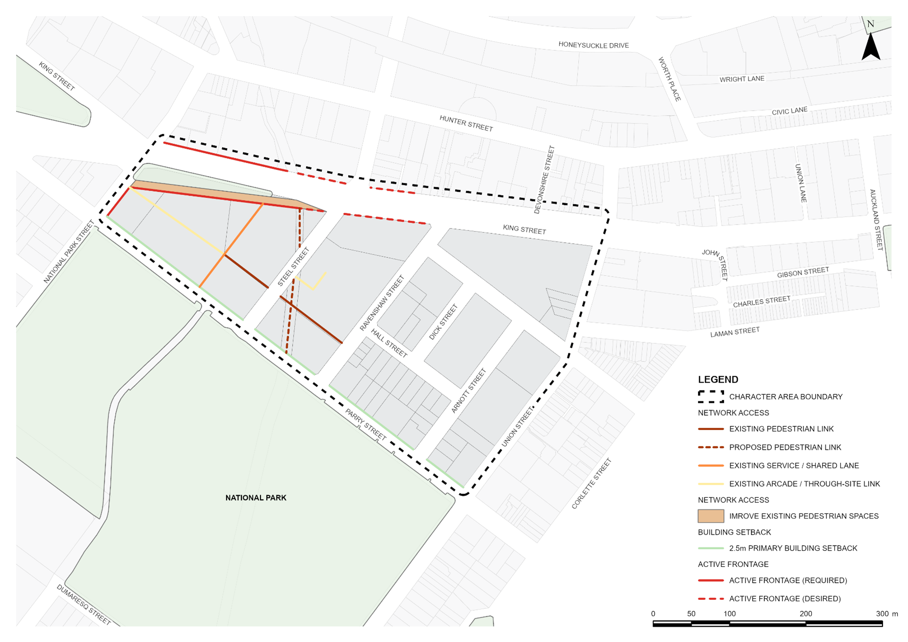
Desired character statement The East End Character Area is identified in Figure E5.31 and is draped across an undulating landscape overlooking the retail and entertainment spine of Hunter Street Mall. The subdivision pattern is fine grained with distinctly varied and interesting facades. A mix of historic buildings (both listed and unlisted) give the area rich character and eclectic streetscapes. Infill development and adaptive reuse of historic buildings breathe fresh excitement into the area, including unique offerings from small bars and other complementary late night venues. Streets and open spaces are cooled by dappled canopies of trees while outdoor diners and live performers fill the air with sounds of chatter and music. Access to the foreshore has been opened with safe and inviting connections through the area. The East End Character Area is in Newcastle City Centre, The Hill and Cooks Hill Heritage Conservation Areas. All heritage conservation areas are identified under Schedule 5 of LEP 2012. A Summary Statement of Heritage Significance and Desired Future Character is provided in Section E2 Heritage conservation areas. Hunter Street Mall Key Precinct Hunter Street Mall (located between Perkins and Newcomen Streets) is a safe and attractive shared street for pedestrians and vehicles servicing a diversity of land uses and building types. The mall is activated by endless choice of retail, dining, entertainment, nightlife and event options. The precinct respects and leverages its rich cultural heritage with views of Christ Church Cathedral, and many well-kept heritage facades and contributory buildings. The mall is a boutique pedestrian-scaled thoroughfare which encourages activity on the street through unbroken active frontages, high quality facades and generous public art. Hunter Street Key Precinct Hunter Street features some of Newcastle’s most valued heritage buildings and offers a mix of shops, cafes, restaurants, and other local businesses. Removal of the former rail line which ran directly to the northern edge of Hunter / Scott Streets between Crown and Newcomen Streets has reactivated this interface. New development provides great amenity to the former rail land, reorientating itself to the corridor and improving solar access rather than turning its back to the corridor as older development fronting Wharf Road once did. New mixed use development, greater pedestrian priority and transport improvements have made Hunter Street and Scott Street a real focus of life in the Newcastle city centre. Infill development on the northern side of Hunter Street between the alignments with Crown and Brown Streets has promoted activity with a strong pedestrian interface and street edge definition. New built form at this location has been sensitively scaled to allow for the maintenance of significant view lines from the adjoining residential apartments to the north. The precinct provides unique key worker or live-work style units fronting Hunter Street with ground floor commercial retail or office uses. |
|
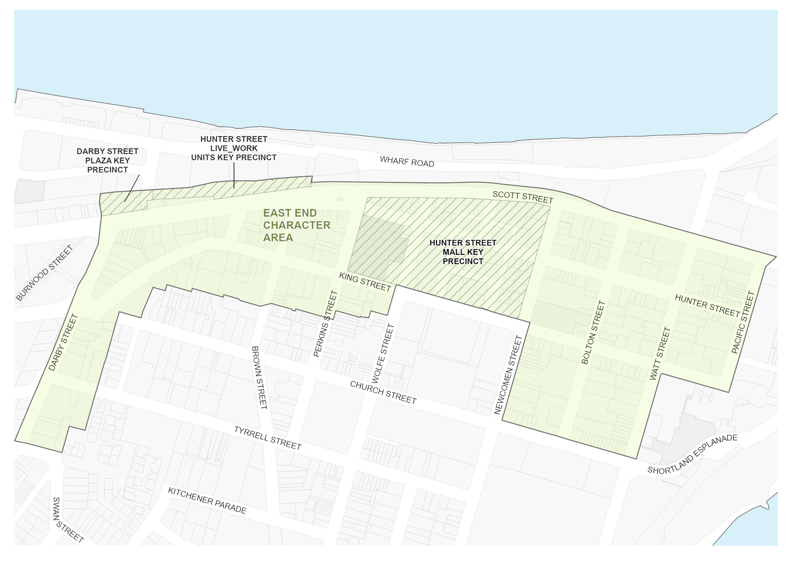
Performance criteria (PC) | Design criteria (DC) | Explanatory note(s) |
PC-1. Hunter Street is enforced as the main retail spine of the area, activated as a key pedestrian path and meeting place, supported by a range of complementary uses. | DC1-1. Development in the Hunter Street Key Precinct shall be in accordance with Figure E5.33. DC1-2. Large scale new development is articulated to break down expanses of building form into smaller elements to relate to the fine grain of the precinct. DC1-3. Development incorporates active uses at ground level along Hunter Street to support small office or retail uses. DC1-4. Built form is scaled to maintain a comfortable, human scaled streetscape. DC1-5. New development protects sunlight access to the footpath on the south side of Hunter Street between 12 noon and 2pm at midwinter and complies with the design criteria in sub-section 20.0. DC1-6. Pedestrian amenity and walkability is enhanced by the provision of wide footpaths. DC1-7. Windows and balconies overlook Hunter Street to provide natural surveillance and sense of safety. DC1-8. Development provides individual pedestrian entries off Hunter Street. DC1-9. Development is of good quality contemporary design that complements nearby terrace development. DC1-10. Development avoids monotonous design by incorporating articulation and a variety of materials and colours. DC1-11 . Development between Thorn and Morgan Street provides an opening on the Market Street alignment to preserve views of Christ Church Cathedral. |
|
| DC1-12. Views to Hunter River are protected and framed along Market Street, Watt Street and Newcomen Street. DC1-13. First floor verandahs are permitted where they are designed to be sympathetic with the overall form, proportion and division of bays of the buildings to which they are attached. |
|
| ||
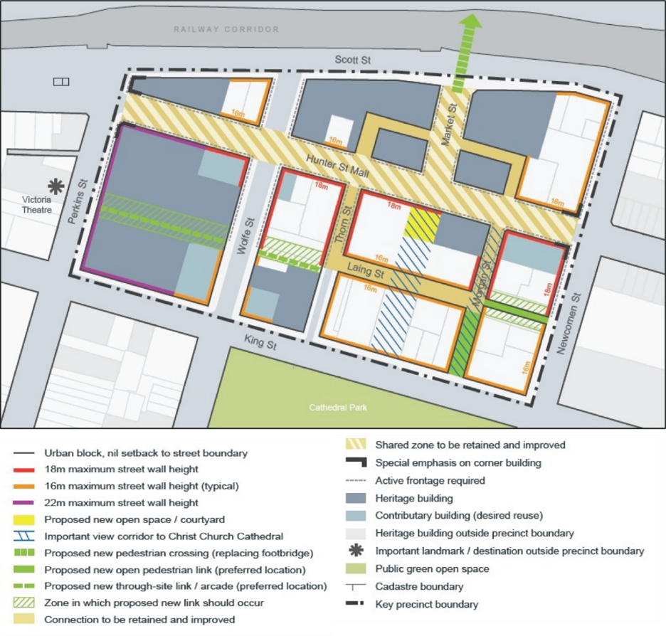 Figure E5.33: Hunter Street key precinct map Figure E5.33: Hunter Street key precinct map | ||
PC-2. Heritage items and contributory buildings and their setting are protected and conserved, including the Aboriginal cultural heritage and non-Aboriginal archaeology. | DC2-1. Development shall be consistent with Section E1 Built landscape heritage and Section E2 Heritage conservation areas. DC2-2. Distinctive early industrial, warehouse and retail buildings that contribute to the character of the area are retained and re-purposed, including prominent corner buildings. DC2-3. Heritage items and contributory buildings are retained and adaptively re-used where suitable. DC2-4. Building form integrates with existing heritage character and echoes historic design elements. DC2-5. In-fill buildings, additions and alterations will respond to the height, massing and predominant horizontal and vertical proportions of existing buildings. DC2-6. New development will incorporate sufficient setbacks from the AA Company Bridge abutment (Heritage Item I415 under LEP 2012) so that it is conserved and retained in situ for permanent public display. | Heritage items are identified under Schedule 5 of LEP 2012. Contributory buildings are identified in the Contributory Buildings Maps in the Newcastle Heritage Technical Manual. Refer to Section B4 Aboriginal Cultural Heritage and Section B5 Historical Archaeology. |
PC-3. A permeable street network with well-connected easily accessible streets and lanes is promoted, where pedestrian, bicycle and public transport users are prioritised over private vehicles. | DC3-1. Improved and new pedestrian connections and laneways are to be provided in accordance with Figure E5.32 and Figure E5.33 and the City Centre Public Domain Technical Manual. |
|
PC-4. Street wall heights and ground level setbacks complement heritage buildings and contributory items whilst reinforcing the desired future character East End. | DC4-1. The street wall height of new buildings or alterations and additions to existing buildings shall be in accordance with Figures E5.32 and Figure E5.33 or as per sub-section 6.0. In the event of any inconsistency, the street wall heights in Figure E5.32 and Figure E5.32 will prevail. DC4-2. The ground floor shall be built to the street frontage unless specified otherwise in Figure E5.32 and Figure E5.33. Where a setback is provided, it may contain pedestrian areas, steps, ramps, landscape features and the like but should not contain utility structures or barriers that restrict visual permeability or pedestrian movement. | Heritage items are identified under Schedule 5 of LEP 2012. Contributory buildings are identified in the Contributory Buildings Maps in the Newcastle Heritage Technical Manual. |
PC-5. In identified activity hubs, ground floor uses add to the liveliness and vitality of the street. | DC5-1. Active frontages are to be provided in accordance with Figure E5.32 and Figure E5.33, on through-site links and pedestrian oriented lanes. |
|
PC-6. Servicing and access minimises conflicts with pedestrians. | DC6-1. Service deliveries are not to be made from Hunter Street for development which has access to another street frontage. DC6-2. For development that has no other frontage than Hunter Street, hours for service deliveries are restricted to minimise potential conflicts with other activities. DC6-3. Vehicle access and servicing is located to minimise conflicts with pedestrians. DC6-4. Loading docks and their access points are not permitted on Hunter Street. |
|
PC-7. Existing laneways and pedestrian connections are enhanced. | DC7-1. A highly permeable street and laneway network in the Hunter Street Mall precinct is provided which is safe, comfortable and welcoming for pedestrians in accordance with Figures E5.32 and Figure E5.33. DC7-2. Recreational opportunities are created by establishing public space and pedestrian connections from Scott Street to the Hunter River foreshore. DC7-3. A pedestrian only link at least 3m in width is provided between Newcomen and Laing Streets, connected to Laing Street. DC7-4 .Vehicle access and car parking is provided via a rear laneway from Argyle Street. DC7-5 .A 10m vehicle turning head is provided at the eastern end of the rear access lane to allow vehicles to exit the site to Argyle Street. DC7-6. Development in the Hunter Street Live-Work Key Precinct shall be in accordance with Figure E5.34. DC7-7. The heritage significance of item 'Remains of AA Company, bridge and fence' (LEP item I415) shall be maintained and conserved. DC7-8. Live work units provide adequate parking accessed from the laneway. Required car parking may be provided within the access laneway (Hunter Street Live-Work Units only), rather than individual lots. DC7-9. Upper level setbacks to the Live-Work units access laneway will be provided in accordance with Figure E5.35. |
|
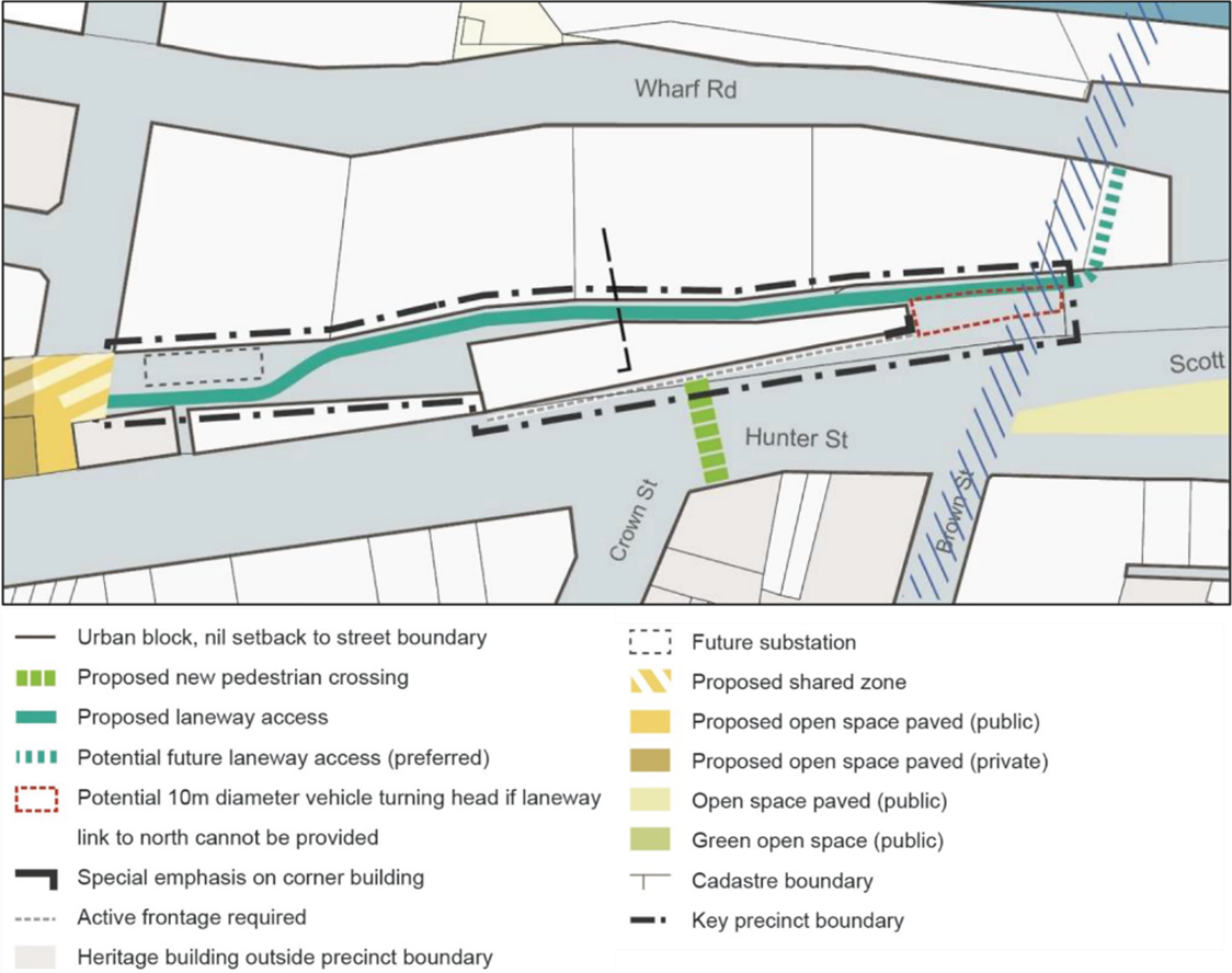 Figure E5.34: Hunter Street live work units key precinct map Figure E5.34: Hunter Street live work units key precinct map | ||
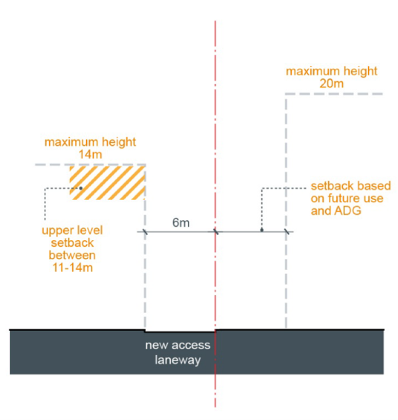 Figure E5.35: Section through Hunter Street live work units Figure E5.35: Section through Hunter Street live work units | ||
PC-8. Diversify the role of Hunter Street Mall precinct as a destination for many activities including retail, dining, entertainment, nightlife and events. | DC8-1. Provide a centrally located one way share-way for vehicles with threshold treatments between Perkins and Newcomen Streets. DC8-2 .Provide additional street trees, new street furniture, new lighting, bike rings and way finding signage. DC8-3. Provide limited short stay car parking with priority given to accessible parking spaces. DC8-4. Provide a centrally located space that is relatively clear of obstructions that can be used for special events. DC8-5. Define clear pedestrian spaces along the fronts of buildings. DC8-6. Integrate Market Street into the mall using common public domain materials and treatments. DC8-7. Remove existing lightweight and concrete freestanding awnings structures. |
|
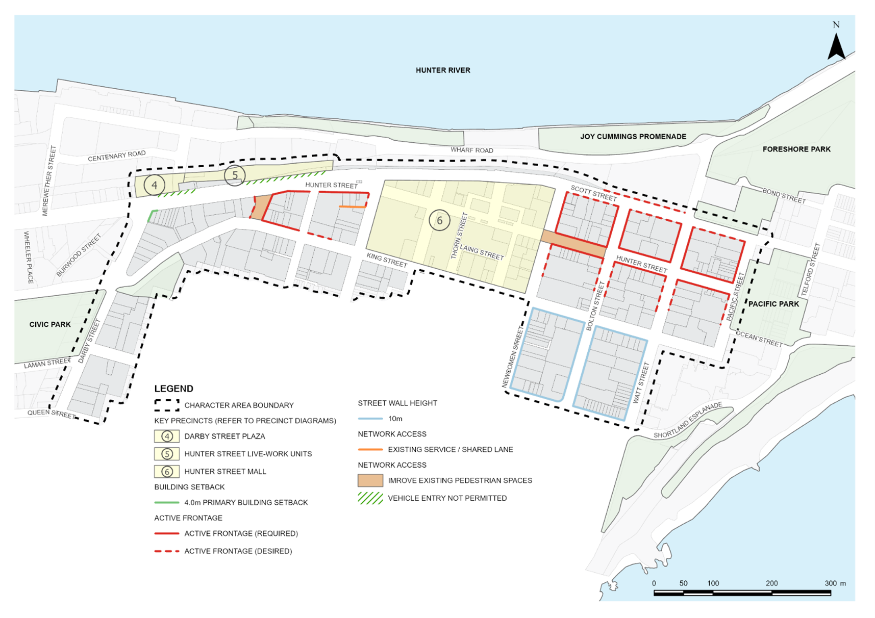
Desired character statement The Newcastle Beach character area is identified in Figure E5.36 and has a cluster of high rise tourist and visitor accommodation and residential apartments overlooking the beach. New development has been accompanied by public domain improvements and strong pedestrian through-site connections to the beach front. Development provides a sensitive transition to respond to the adjoining lower scale development in Newcastle East Heritage Conservation Area. |
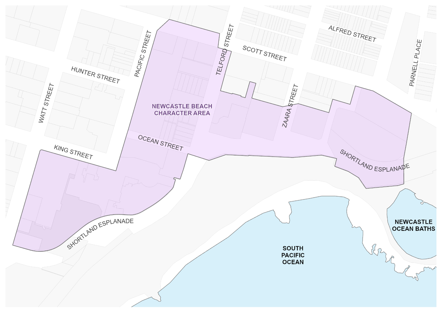 Figure E5.36: Newcastle Beach character area Figure E5.36: Newcastle Beach character area |
| Note: The Newcastle Beach Character Area is in Newcastle East Heritage Conservation Area. Newcastle East Heritage Conservation Area is identified under Schedule 5 of LEP 2012. A Summary Statement of Heritage Significance and Desired Future Character is provided in Section E2 Heritage conservation areas. |
Performance criteria (PC) | Design criteria (DC) | Explanatory note(s) |
PC-1. The high environmental quality of the area is maintained.
| DC1-1. New development addresses the street to provide a good interface with the public domain. DC1-2. Development adjoining Newcastle East Heritage Conservation Area creates a transition in scale by aligning the scale, proportion, form and finishes of the associated buildings. DC1-3. The public domain and amenity is enhanced. DC1-4. Pedestrian access to Newcastle Beach is improved. |
|
PC-2. Heritage items and contributory buildings and their setting are protected and conserved, including the Aboriginal cultural heritage and non-Aboriginal archaeology. | DC2-1. Development shall be consistent with Section E1 Built landscape heritage and Section E2 Heritage conservation areas. DC2-2. Heritage items and contributory buildings are retained and adaptively re-used where suitable. | Heritage items are identified under Schedule 5 of LEP 2012. Contributory buildings are identified in the Contributory Buildings Maps in the Newcastle Heritage Technical Manual. Refer to Section B4 Aboriginal Cultural Heritage and Section B5 Historical Archaeology. |
PC-3 . A permeable street network with well-connected easily accessible streets and lanes is promoted, where pedestrian, bicycle and public transport users are prioritised over private vehicles. | DC3-1. Improved and new pedestrian connections and laneways are to be provided in accordance with Figure E5.37 and the City Centre Public Domain Technical Manual. |
|
| ||
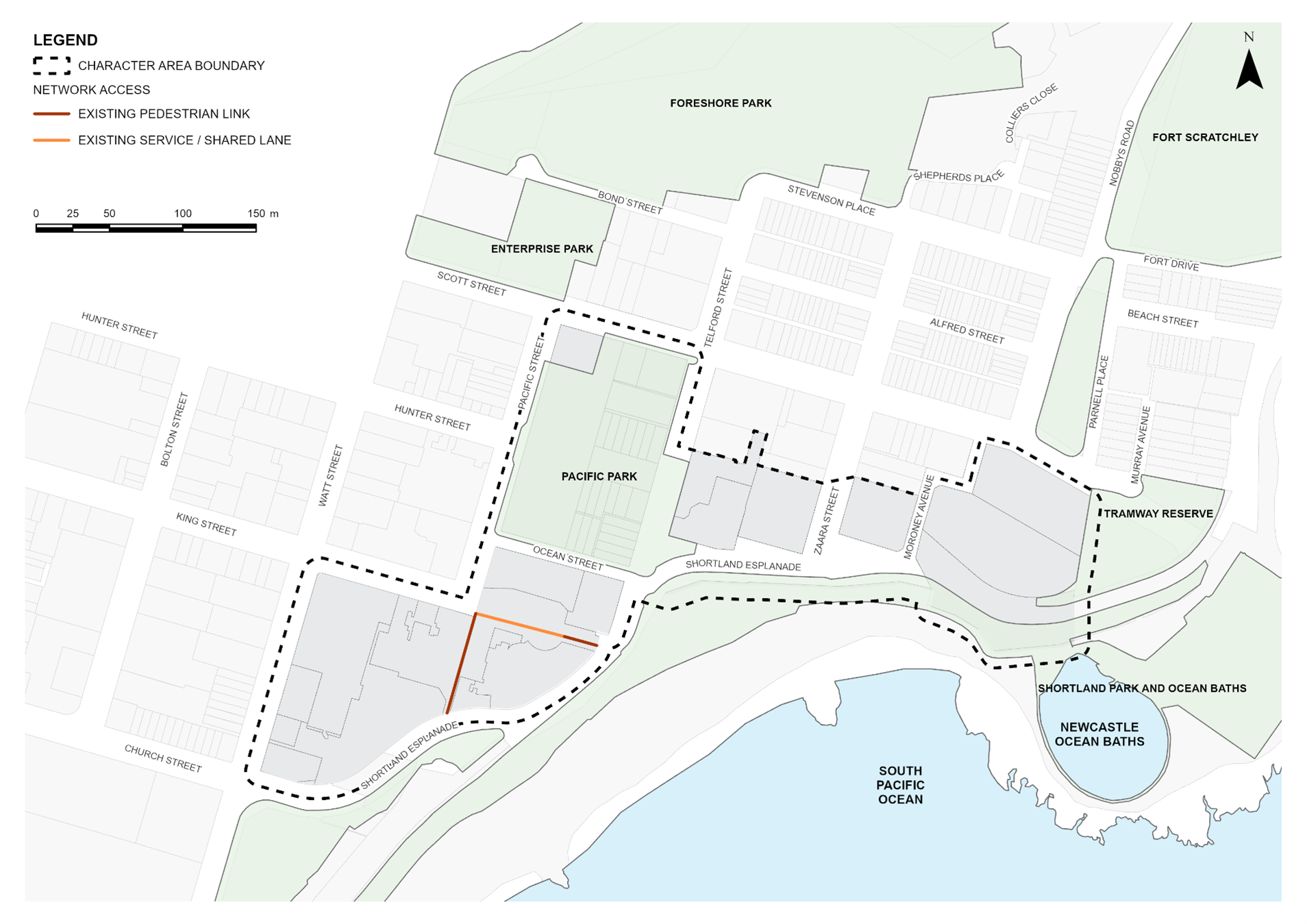
Desired character statement The low-rise residential precinct in Newcastle East Heritage Conservation Area is identified in Figure E5.38 and is characterised by an intact heritage streetscape and by a collection of highly significant heritage items. It is a well-kept cultural landscape that provides a record of the early development of Newcastle. The area is primarily residential with terrace housing dating from the late nineteenth century. Small corner shops and other ancillary retail or commercial uses are present. Terrace houses are built to the street boundary, with many featuring first floor verandas that overhang the footpath. The fringes of the area feature heritage listed warehouses that have been converted for residential and commercial uses. Notable buildings include Fort Scratchley Historic Site, Earp Gillam Bond Store, Boatman's Row, the Cohen Bondstore and Coutt’s Sailors Home. The heritage values of the area are supported by its relationship with the adjacent Coal River Precinct, a place of outstanding heritage significance listed on the NSW State Heritage Register. |
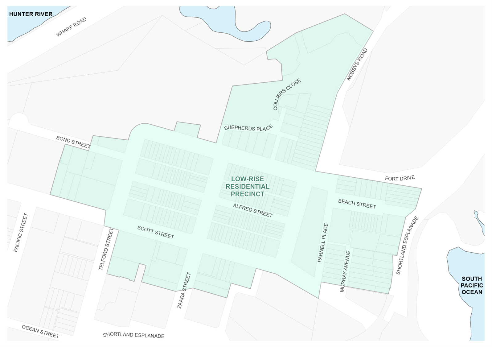 Figure E5.38: Low-rise residential precinct in Newcastle East Heritage Conservation Area map Figure E5.38: Low-rise residential precinct in Newcastle East Heritage Conservation Area map |
| Note: The character area is in Newcastle Heritage Conservation Area. Newcastle East Heritage Conservation Area is identified under Schedule 5 of LEP 2012. A Summary Statement of Heritage Significance and Desired Future Character is provided in Section E2 Heritage conservation areas |
Performance criteria (PC) | Design criteria (DC) | Explanatory note(s) |
PC-1. The heritage significance of Newcastle East Heritage Conservation Area is retained and conserved, including the Aboriginal cultural heritage and non-Aboriginal archaeology. | DC1-1. Development shall be consistent with Section E1 Built landscape heritage and Section E2 Heritage conservation areas. DC1-2. Development responds to and complements heritage items and contributory buildings within the heritage conservation area, including streetscapes and lanes. DC1-3. New development respects the scale, character and significance of existing buildings. DC1-4. Existing views and vistas are maintained in and out of the area to the water and the foreshore parkland. DC1-5. The continuity of Newcastle East's significant heritage places are retained and conserved, the diverse social mix of the area is maintained. DC1-6. Contributory and historic buildings, particularly intact or historically significant groupings, heritage items, iconic structures, and the appearance and layout of streets are maintained. DC1-7. Sandstone retaining walls, street features such as sandstone kerbing and guttering, and other features of historical interest such as coal shutes, public stairs, lanes, parks, views and vistas are maintained. DC1-8. The eclectic and organic nature of the urban pattern and varying ages of the building stock that demonstrates the gradual urbanisation during the 19th and 20th century of a once indigenous landscape are maintained. DC1-9. The existing appearance of the Hill, views outwards to the coastline and harbour and views into the area from the City, foreshore and Stockton which reveal a tree-lined suburb with a steep topography are maintained. | Heritage items are identified under Schedule 5 of LEP 2012. Contributory buildings are identified in the Contributory Buildings Maps in the Newcastle Heritage Technical Manual. Refer to Section B4 Aboriginal Cultural Heritage and Section B5 Historical Archaeology. |
| DC1-10. Gardens, street trees and public open space and existing subdivision pattern and street layout are maintained. DC1-11. First floor verandahs are permitted where they are designed to be sympathetic with the overall form, proportion and division of bays of the buildings to which they are attached. |
|
PC-2. A permeable street network with well-connected easily accessible streets and lanes is promoted, where pedestrian, bicycle and public transport users are prioritised over private vehicles. | DC2-1. Pedestrian connections and laneways are to be provided in accordance with Figure E5.39 and the City Centre Public Domain Technical Manual. |
|
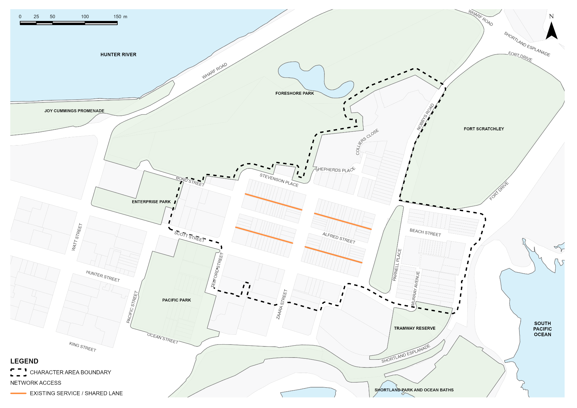 Figure E5.39: Low-rise residential precinct in Newcastle East Heritage Conservation Area locality map Figure E5.39: Low-rise residential precinct in Newcastle East Heritage Conservation Area locality map | ||
Desired character statement The Foreshore Character Area is identified in Figure E5.40 and is an extensive primary open space asset for the Newcastle's city centre and broader local government area. It showcases the city’s unique natural setting, between the Hunter River and the Pacific Ocean. The foreshore provides public access linking the river and ocean waterfronts and is also the location of many significant heritage places such as Newcastle Railway Station buildings, Fort Scratchley, Customs House, the Ocean Baths and Nobbys Point Lighthouse. Development is interwoven in the landscape and complements the leisure, recreation and heritage uses of the Foreshore area including Nobbys Beach, Newcastle Beach, Queens Wharf, Nobbys Beach Surf Pavilion, and the foreshore cycleway and promenade. The Foreshore Character Area is in Newcastle East Heritage Conservation Area that is identified under Schedule 5 of LEP 2012. A Summary Statement of Heritage Significance and Desired Future Character is provided in Section E2 Heritage conservation areas. Newcastle Station and Foreshore Park Key Precinct The State listed Newcastle Railway Station is a central focal point for the area. It contributes greatly to the urban environment including views of the building itself and influence on key built forms in its surrounds. Newcastle Railway Station is repurposed into a hallmark destination, retaining and adapting the heritage character with a mix of uses and providing a focal point for the East End. It accommodates enterprises and activities that attract visitors, activate the area and stimulate the economy. The new uses of the station are supported and enhanced by the expansion of the Foreshore Park to the west of the station which provides vast and flexible open space for passive and active recreation, community uses and event spaces. The character of Newcastle Station and Foreshore Park Key Precinct respects and celebrates the heritage integrity of the Station, while accommodating a range of different activities including community, tourism, retail, leisure and commercial uses. Multi-purpose Community Space Key Precinct The precinct is a multi-purpose community civic space, incorporating a community facility and public domain space. Activating the western end of this public space with a multi-purpose building provides important casual surveillance of the open space area. Active frontages improve the streetscape at Wharf Road and Scott Street. Important views and foreshore access are retained. The precinct is popular with residents, visitors and workers. The site is identified as a key site under LEP 2012. This ensures that future development exhibits design excellence and complements the wider Foreshore Character Area. | ||
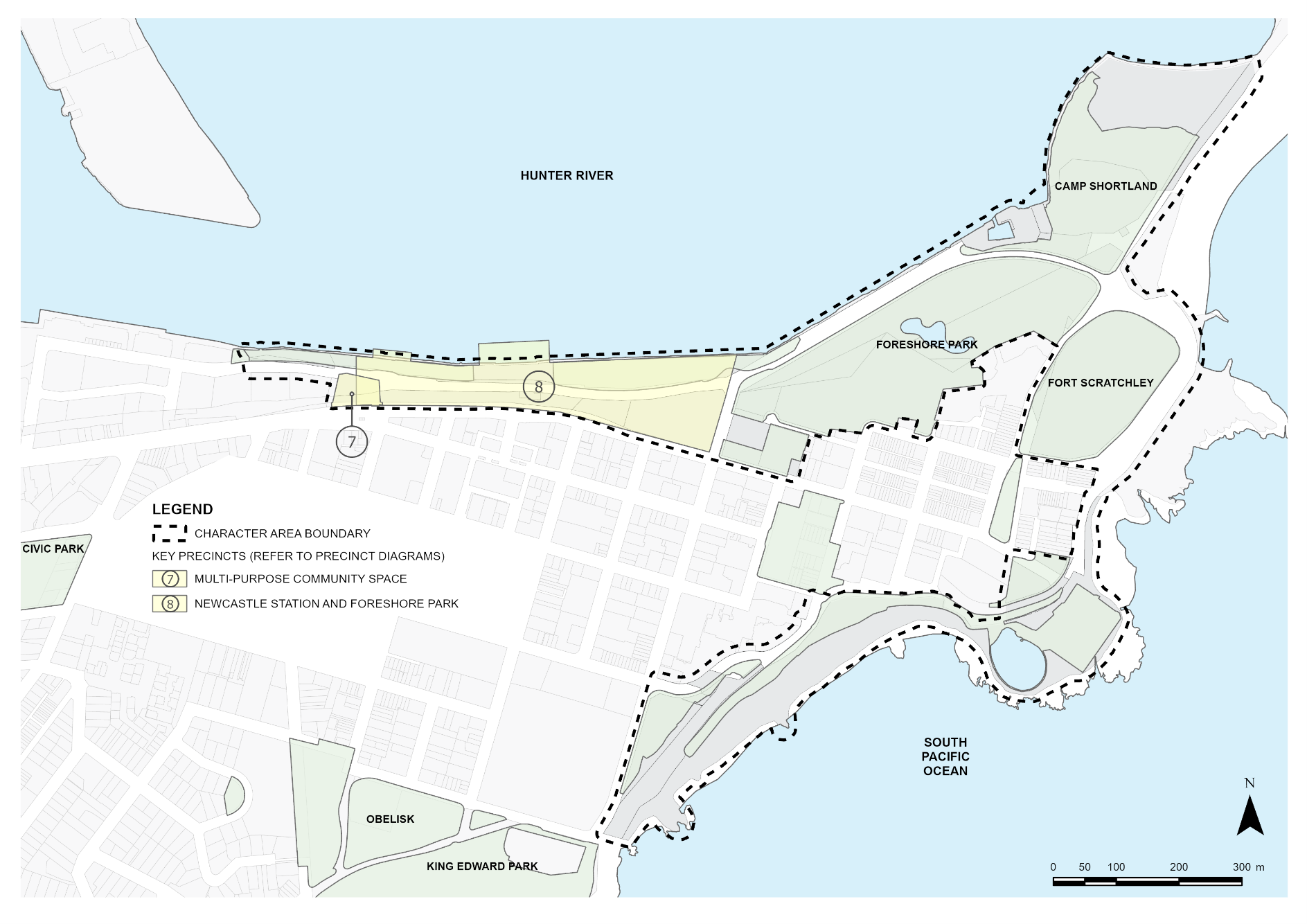 Figure E5.40: Foreshore character area locality map Figure E5.40: Foreshore character area locality map | ||
Performance criteria (PC) | Design criteria (DC) | Explanatory note(s) |
PC-1. The area is enhanced and continues to be the city's major recreational open space for Newcastle’s workers, residents and visitors. | DC1-1. New development promotes and facilitates the continuity of public access to the whole foreshore. DC1-2. Recreational opportunities are created by new public open space and key access links to the foreshore. |
|
PC-2. Heritage items and contributory buildings and their setting are protected and conserved, including the Aboriginal cultural heritage and non-Aboriginal archaeology. | DC2-1. Development shall be consistent with Section E1 Built landscape heritage and Section E2 Heritage conservation areas. DC2-2. New development respects the scale, character and significance of existing buildings, especially heritage items and contributory buildings. DC2-3. The adaptive re-use of the Newcastle Railway Station maximises the long-term potential of the site as a major visitor and community focal point. DC2-4. The heritage and history of the Newcastle Station is preserved through its adaptive re-use. DC2-5. Pedestrian movement networks are developed around, and through, the heritage buildings. DC2-6. Heritage items located adjacent to public open space integrate with the public domain. | Heritage items are identified under Schedule 5 of LEP 2012. Contributory buildings are identified in the Contributory Buildings Maps in the Newcastle Heritage Technical Manual. Refer to Section B4 Aboriginal Cultural Heritage and Section B5 Historical Archaeology. |
PC-3. Vistas from public spaces to the waterfront, prominent heritage items and landmarks are protected and reinforced. | DC3-1. View corridors are maintained along Brown Street and Perkins Street through to the harbour. DC3-2. Views of Newcastle Station along Scott Street, particularly the main building and the Western Wing are maintained. DC3-3. The view corridor from the harbour front to the roof elements on the main building and Western wing from a pedestrian level is maintained. DC3-4. The view corridor from the west to Customs House is maintained. The bulk of new structures does not obscure views to and from the clock element on Customs House, beyond what has already been established. DC3-5. Vegetation and vertical elements in open space are sited to ensure existing visual corridors between the harbour and Perkins Street are maintained. DC3-6. Views to Nobbys Headland from Scott Street and the precinct are enhanced. New development takes advantage of the views to the harbour and Nobbys Headland. |
|
PC-4. Newcastle Station and Foreshore Park is developed as a regional tourist and leisure destination for both residents and tourists. | DC4-1. Newcastle Station and Foreshore Park is developed in accordance with Figure E5.41. DC4-2. The general bulk of any new development on the site does not compete with, impede or detract from the current tiered elevation and depth created by the built form in its current configuration. DC4-3. The form, massing, scale and bulk of new development are complementary to the existing built form of the Newcastle Railway Station. |
|
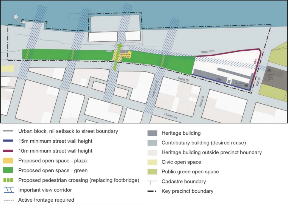 Figure E5.41: Newcastle Station and foreshore park key precinct map Figure E5.41: Newcastle Station and foreshore park key precinct map | ||
PC-5. Provide a new multi-purpose community place and space that encourages use by residents and regional tourists. | DC5-1. The Multi-purpose Community Space precinct is developed in accordance with Figure E5.42. DC5-2. The bulk and scale of new development does not compete with or impede or detract from the surrounding areas and enhances connection to Market Street Lawn and other areas of open space. DC5-3. New development improves pedestrian permeability and amenity between Hunter Street, Scott Street and the harbour. New Development integrates with Foreshore Park and encourages pedestrian access and permeability. DC5-4. New built form addresses Scott Street and Wharf Road and has frontage and activation to Market Street Lawn. DC5-5. New Development provides for the minimum 6m wide lane access. DC5-6. Trees are retained on site where possible. If trees cannot be retained, then replacement of trees on site are in accordance with Section C3 Vegetation preservation and care. DC5-7. Any future works on this site require geotechnical assessment of mine subsidence risk to ensure that the site is not impacted by convict-era workings. DC5-8. Landscape works adjacent to the public domain of Wharf Road will be consistent with the Foreshore Precinct Public Domain Plan. |
|
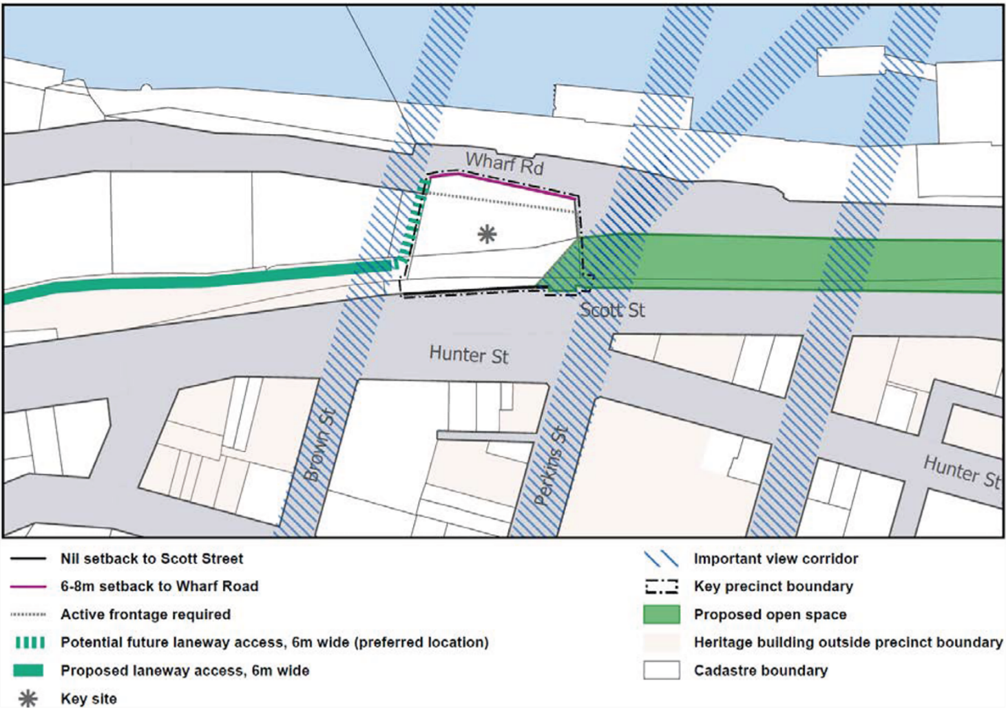 Figure E5.42: Multi-purpose community space precinct Figure E5.42: Multi-purpose community space precinct | ||