Section D1 Subdivision and lot consolidation
Subdivision is the process of subdividing land into parts (two or more) that, after the division, would be adapted for separate occupation, use or disposal.
Land subdivision can have significant influence and long-term effects on the urban fabric, future development potential and the economic performance of an area. Therefore, proposals that relate to streets, blocks, lots and open space need careful consideration as the result can reduce or improve street connectivity and permeability, change the character of an area and affect the safety and vibrancy of public space.
Well planned subdivisions can achieve quality design and development outcomes by encouraging safe, convenient and attractive residential neighbourhoods. Planned industrial and commercial estates can meet the diverse and changing needs of the community while protecting strategically important elements of our local natural environment.
This section applies to all land to which the Newcastle Local Environmental Plan 2012 (LEP 2012) applies, and to land outside of the Port of Newcastle lease area to which State Environmental Planning Policy (Transport and Infrastructure) 2021 applies.
The following sections will also apply to development:
- C1 Traffic, parking and access
- C2 Movement networks
- C3 Vegetation preservation and care
- C4 Stormwater
- C5 Soil management
- C6 Waste management
- C7 Safety and security
- C11 Development adjoining laneways
- C12 Open space and landscaping
The following sections may also apply to development:
- B1 (a) Flood management - pre 2019 flood studies
- B1 (b) Flood management - post 2019 flood studies
- B2 Bush fire protection
- B3 Mine subsidence
- B4 Aboriginal cultural heritage
- B5 Historical archaeology
- B7 Land contamination
- C8 Social impact
- D2 Single dwelling and ancillary development
- D3 Residential development
- D4 Commercial
- D5 Industrial
- D6 Community services
- D7 Sex industry establishments
- All of Part E: Place and precincts
Associated technical manual/s
- Newcastle Subdivision Technical Manual 2014, The City of Newcastle
- Disability Standards for Accessible Public Transport, 2002, Commonwealth of Australia
- Austroads Publications and Guides
- Model Agreement for Local Councils and Utility/Service Providers, Streets Opening Conference, http://www.streetsopening.com.au/
Additional information
- Movement and Place, NSW Government
- Guidelines for Bus Capable Infrastructure in Greenfield Sites, Transport for NSW
- Controlled Activities – Guidelines for riparian corridors on waterfront land, NSW Water
- Planning for Bushfire Protection, 2019, NSW Rural Fire Service
- YourHome, 2022, Commonwealth of Australia
- Identify expectations and requirements relating to standards of subdivision design and construction, and information required to be submitted.
- Outline expectations for the quality of any new public assets and lands.
- Minimise onsite and offsite adverse impacts on the natural and built environment.
- Ensure all lots are physically capable of development and can be satisfactorily serviced by infrastructure and utilities services and have an appropriate level of access and amenity.
- Provide a variety of lot sizes, type, and configurations to enable a functional and desirable mix of densities, forms, and types to promote housing choice, create attractive streetscapes and open space with distinct character, and improve access to services.
- Reduce the risk of potential land use conflict.
- Achieve efficient use of land.
- Ensure sensitive land uses and development are adequately buffered from Summerhill Waste Management Centre.
- Minimise industrial land fragmentation, particularly for areas of strategic importance or in proximity to key infrastructure.
- Retain, protect, and enhance riparian and biodiversity corridors; increase connections between habitat patches.
- Ensure subdivision promotes safe and convenient movement of vehicles, pedestrians, and bicycles.
- Ensure subdivision considers climate related risks and provides an integrated response to natural hazards.
A word or expression has the same meaning as it has in LEP 2012. Other words and expressions include:
- Access handle – means the portion of a battle-axe lot primarily providing vehicular and services access to a road.
- Community title subdivision – is the form of title created under the Community Land Development Act 2021 and the Community Land Management Act 2021. Community title provides individual ownership of lots (with buildings and structures erected on the lots as in conventional subdivision) and a share in the association property. Association property is a lot in the scheme on which community facilities may be erected. Association property can include land for roads and driveways, swimming pools and other common facilities, common open space areas and common infrastructure facilities, such as asset protection zones and the like.
| Note: Community title subdivision can be particularly useful where individually owned lots are required, but where common property and/or facilities are desired or required by Council. An example of the latter may be where there is a requirement to maintain a vegetated riparian zone on a private watercourse which flows across a number of private property boundaries. |
- Dwelling density – means the ratio of the number of dwellings proposed to be located on the land to the area of the land to be occupied by the development. The area of land includes internal streets and half the width of any roads adjoining the development that provide vehicular access to the development, but excludes land deemed undevelopable due to constraints and land used for public open space and non-residential purposes.
- New residential site – is identified through land use zoning for future urban development. It has not been developed and is located outside the existing urban area.
- Riparian zone – is a transition zone between land and a waterway (creek, watercourse, wetland, estuary, or river). They provide ecosystem corridor services and support waterway stability. They help buffer land from erosion impacts during extreme storms. Generally, a width of 40m is the minimum viable riparian zone. Under the NSW Water Management Act and guidelines, riparian zones include the waterway 'floor' and land beyond the top of the waterway bank (Controlled activities – Guidelines for riparian corridors on waterfront land, NSW Department of Planning and Environment, undated). The top of bank is measured by Digital Terrain Model, site engineering survey or similar. See also Vegetated Riparian Zone.
- Solar access – is the ability of a building to continue to receive direct sunlight without obstruction from other buildings or impediments, not including trees.
- Site analysis – means the identification and analysis of the existing characteristics and constraints of a site and its surrounding area. It is designed to assist in understanding the locality and inform appropriate design response.
- Strata subdivision – defined as ‘subdivision’ in the Environmental Planning and Assessment Act 1979. Strata subdivision can subdivide buildings and land into separate lots capable of individual ownership, with additional areas of land designated as common property. Those owning lots within the scheme have a proportional entitlement to use the common property and also a proportional responsibility for its maintenance. Examples are buildings such as townhouses, flats, industrial units and shops, with outside areas such as gardens, driveways and car parking spaces usually being part of the common property lot, owned and managed by the ‘Owners Corporation’.
- Subdivision certificate – a certificate that authorises the registration of a plan of subdivision in the Land Titles Office.
| Note: At present, accredited certifiers may not issue a subdivision certificate, unless authorised to do so by an environmental planning instrument. |
- Subdivision work – is any physical activity authorised to be carried out in connection with a subdivision under the conditions of a development consent for the subdivision of land.
- Subdivision works certificate – is a certificate to the effect that subdivision work completed in accordance with specified plans and specifications will comply with the requirements of the regulations and must be obtained before carrying out the subdivision work.
- Torrens title subdivision – is the ‘single lot’ form of subdivision, common in many estates. The Torrens title system is based on a plan of survey, or a plan compiled from survey, which defines the boundaries of a parcel of land at the date upon which it was registered.
| Note: Subdivision proposing less than 20 lots may be classed as medium scale and development of more than 20 lots as large scale development. |
- Urban release area – means the area of land identified as 'Urban Release Area' on the Urban Release Area Map in LEP 2012.
- Vegetated Riparian Zone – is the inner portion of the riparian zone: closest to the top of a waterway bank. The top of bank is identified using Digital Terrain Model, site engineering survey or similar. See also Riparian Zone, Controlled activities – Guidelines for riparian corridors on waterfront land, NSW Department of Planning and Environment, undated).
Development category | Application requirements | Explanatory notes |
All strata subdivision development applications (DA) | The following information is to be submitted as part of any application proposing a strata subdivision:
| Discretion will be used regarding the extent of information required for each site analysis (eg a simple two lot subdivision would not necessarily require the same level of detail as a major subdivision development). However, a simple two lot subdivision on land with a watercourse and/or high flood risk will have more requirements than a site without these constraints. |
All Torrens title subdivisions of approved residential developments | A site analysis is submitted to the level of detail required to assess the potential impacts associated with the nature, type and scale of the development and its surroundings, and is to include:
| |
All Torrens title subdivisions creating vacant lots (up to three lots) | A site analysis is submitted to the level of detail required to assess the potential impacts associated with the nature, type and scale of the development and its surroundings, and is to include:
Other items that may be required in addition to the above, include:
| |
All Torrens title subdivisions creating vacant lots (more than three vacant lots) | A site analysis is submitted to the level of detail required to assess the potential impacts associated with the nature, type and scale of the development and its surroundings, and is to include:
Other items may be required in addition to the above, include:
| |
All community title subdivision DAs | In addition to the submission requirements for a Torrens title subdivision, a community title subdivision is to be accompanied by the following documents:
| The relevant legislative provisions can be found in the Community Land Development Act 1989 and Community Land Management Act 1989, as amended. If development consent is ultimately granted to the community title subdivision, the final Management Statement and final Development Contract will be required to be lodged with the final plan of subdivision as part of the subdivision certificate application. |
All Strata, Torrens title and Community title subdivisions located on land which is a heritage item and/or in a heritage conservation area or located on land in the vicinity of a heritage item and/or heritage conservation area. | A heritage impact statement is submitted to the level of detail required to assess the potential impact of the proposed subdivision on the heritage significance of the heritage item and/or the heritage conservation area, and how any impact arising from the changes will be mitigated. This statement is to conform to the standards in the Environment and Heritage Group of the NSW Department of Planning and Environment publications. The heritage impact statement must address:
The statement should clearly identify and explain the extent of the proposed subdivision works and reference all DA drawings. The statement should include options considered for the proposal and documented reasons for choosing the preferred option. These should include proposals to minimise the impact of the subdivision on the heritage significance of the heritage item and/or heritage conservation area. Provide three-dimensional building envelopes for future built form to each lot proposed. The inclusion of supplementary consultants’ reports, for example a preliminary archaeological assessment report, Interpretation strategy report or Aboriginal cultural heritage assessment report, may be required if further detailed assessment is necessary and relevant to the application. The length of the heritage impact statement will vary depending on the scale and complexity of the proposal. As such:
| A heritage impact statement should perform the following four main functions:
Environment and Heritage Group of the NSW Department of Planning and Environment publications include Guidelines for Preparing a Statement of Heritage Impact, 2023 and Assessing Heritage Significance, 2023, and The Principles and processes of the Burra Charter, 2013. 'Vicinity of' means development on land located adjacent to a heritage item or the boundary of a heritage conservation area, or development on land that would affect the heritage significance or setting, including significant views, of a nearby heritage item or heritage conservation area. Subdivision applications for land containing heritage items should be accompanied by adequate plans showing existing contours or levels, buildings, works, trees, and site features (e.g. dams), future building envelopes and the siting and setbacks of any proposed buildings. The heritage impact statement should demonstrate that the:
Refer to Section E1 Built and landscape heritage and Section E2 Heritage conservation areas. Refer to Section B4 Aboriginal cultural heritage and Section B5 Historical archaeology. |
Subdivision within Summerhill Waste Management Centre Buffer areas | Subdivision within Summerhill Waste Management Centre Buffer areas may require additional assessments to support the application including noise, odour and/or visual impact assessment. | Discretion will be used regarding the extent of information required. |
Objectives
- Provide subdivision lot sizes that meet community and economic needs.
- Facilitate greater diversity in housing choice.
- Ensure lots are of sufficient size to meet user requirements.
- Ensure lot density, location, arrangement, and dimensions are responsive to site constraints and opportunities, while minimising exposure to natural hazards, such as flooding, bushfires, landslides, and coastal erosion.
- Ensure appropriate building siting and access to development.
- Maximise opportunities for energy efficiency and solar access through lot orientation and design.
- Ensure the subdivision of existing or proposed dwellings maintains adequate amenity landscaping, access, parking and fire separation.
Controls (C) | Explanatory notes |
C-1. Road and lot layouts are generally grid patterns and do not rely on cul-de-sacs |
|
C-2. Lots are designed to address existing and proposed public open space. |
|
C-3. A range and mix of lot sizes are produced that:
| Refer to Section E1 Built and landscape heritage and E2 Heritage conservation areas.
|
C-4. Lot sizes and dimensions provide for:
| On steeper land, larger lots should be considered to reduce the visual effects associated with excessive cut and fill on small sites.
|
C-5. Where an application for subdivision proposes to subdivide land which contains:
It must be demonstrated that each dwelling on each proposed lot will comply with Section D2 Single dwelling and ancillary development or Section D3 Residential development. |
|
C-6. Subdivision in an urban release area or new residential site achieves a range of lot sizes to support higher yields closer to 40 dwellings per hectare near open space, retail, commercial, community, recreation facilities and public transport. | City of Newcastle (CN) is a metropolitan city that provides for the daily and weekly needs of residents within a 15 minute neighbourhood through public and active transport means. CN is therefore at a minimum an inner suburban context area as an outcome of the Hunter Regional Plan 2041. |
C-7. Address conflict between land uses with buffer areas incorporated into the subdivision design. |
|
C-8. Intensification of lots is not permitted on land located seaward of the 2120 Zone of Reduced Foundation Capacity (ZRFC) coastal hazard line. | Refer to CN's Stockton Coastal Management Program for 2120 coastal hazard line. |
C-9. Fan shaped lots have a minimum frontage of 9m and a minimum width of 15m measured at 6m from street alignment. | The criteria specified applies to applications proposing subdivision only and is not applicable to the subdivision associated with residential accommodation. |
C-10. Roof and gutter systems are graded with each lot draining independently. If an approved development has other stormwater management systems, such as a detention tank, appropriate easements are established to preserve the owner's legal rights and to ensure maintenance obligations are clearly defined. |
|
C-11. The endorsement of a subdivision certificate for subdivision in conjunction with residential development will generally not be released prior to lock up stage of the associated development. |
|
C-12. All streets associated with the subdivision of land are designed to include footpaths that link to existing footpaths, road crossings, parks and public transport facilities. | All footpaths are to be designed in accordance with CN's Standard Drawings. |
Objectives
- Encourage well designed industrial areas serving a range of general industrial needs.
- Provide the safe and efficient movement of traffic to and from all industrial lots.
- Protect the amenity of adjacent land uses, where necessary, from the effects of industrial development.
- Ensure stormwater is appropriately managed.
Controls (C) | Explanatory notes |
C-1. Lots have a minimum frontage of 25m except in Steel River as provided by C-2. |
|
C-2. Within 'Steel River' lots have a minimum frontage of 60m with no direct access from Industrial Drive, Tourle Street or Pacific Highway as indicated below on Figure D1.01. | See Section D5 Industrial and State Environmental Planning Policy (Transport and Infrastructure) 2021 for further controls in Steel River. |
C-3. Lots are rectangular in shape. |
|
C-4. Lots are designed to address existing and proposed public open space. |
|
C-5. Industrial subdivision provides lots that:
|
|
C-6. The subdivision design allows for PBS (Performance Based Standards – National Heavy Vehicle Regulator) Level 3 vehicles up to 36.5m in length to access the subdivision unless the existing connecting road network is unable to support that vehicle class (subject to NHVR and Transport for NSW approval). | PBS Level 3 vehicles are more efficient freight transportation vehicles than semi-trailers and B-Double trucks and are to be adopted as the design vehicle unless otherwise constrained. |
C-7. Lot size allows trucks to manoeuvre on-site without reversing onto or off the lot. |
|
C-8. Road and lot layouts are generally grid patterns and do not rely on cul-de-sacs. |
|
C-9. Lots are adequately buffered to protect the amenity of sensitive land uses. | Sensitive land uses include, but are not limited to residential development, seniors housing, schools, hospitals, child care facilities, recreation areas, place of worship, community facilities. |
C-10. All streets are designed to include footpaths that link to existing footpaths, road crossings, parks and public transport facilities. | All footpaths are to be designed in accordance with CN's Standard Drawings. |
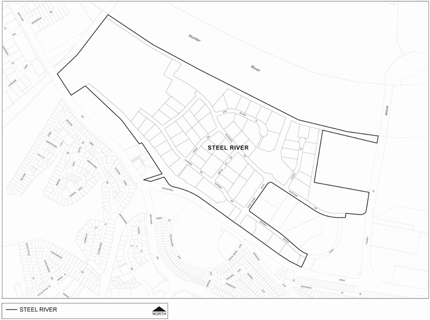 Figure D1.01: Steel River
 Objectives
- Maximise the number of lots which have good solar access.
- Ensure the subdivision of land responds to the natural and built environment.
- Ensure that subdivision of land for residential purposes creates lots of a suitable size, configuration and orientation.
Controls (C) | Explanatory notes |
The following controls apply only to subdivisions in residential zones | |
C-1. Unless site constraints dictate, subdivision layouts are configured such that:
See Figure D1.02 below for preferred lot arrangement. |
|
C-2. Lot orientation results in living areas and private open space of any dwelling or future dwelling being oriented to the north and dwellings positioned to avoid or minimise possible overshadowing of existing or future adjoining buildings. Where site conditions, such as slope, could constrain future development, lot sizes are increased. | Plans may be required showing potential building footprint and open space for constrained sites to ensure that relevant solar access requirements can be achieved. |
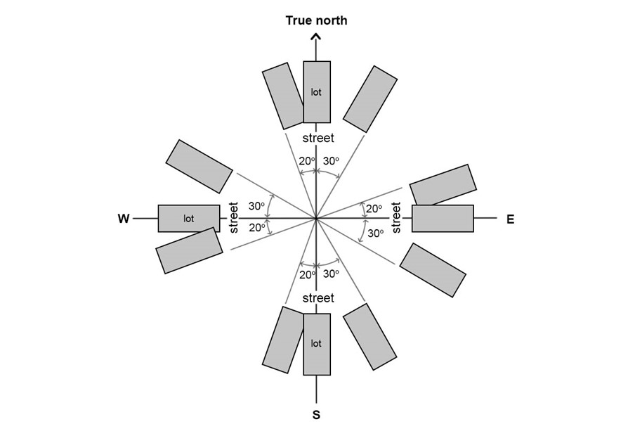 Figure D1.02: Preferred lot arrangement
 Objectives
- Establish effective separation distances, buffers and mitigation measures for the Summerhill Waste Management Centre to minimise adverse effects on sensitive land uses and people from odour, noise, dust, ground gas and other nuisance generating activities.
- Ensure the long-term viability of waste and resource recovery infrastructure is secured by using defined buffer areas that protect against encroachment from incompatible land uses.
Controls (C) | Explanatory notes |
C-1. Subdivision for residential and other sensitive uses should not be within 1000m of approved putrescible landfill cells at the Summerhill Waste Management Centre, unless designed to avoid adverse odour, noise, and visual impacts refer to Figure D1.03. | Appropriate buffer distance must be maintained between the landfill and sensitive land uses (receptors) to protect those receptors from impacts. Impacts might constitute discharge from the site of potentially explosive landfill gas, offensive odours, noise, litter and dust. |
C-2. Subdivision for residential and other sensitive uses should not be within 500m of approved non-putrescible landfill cells at the Summerhill Waste Management Centre, unless designed to avoid adverse odour, noise, and visual impacts refer to Figure D1.03. | |
C-3. Subdivision of land for non-residential purposes should not be within 500m of approved putrescible landfill cells at the Summerhill Waste Management Centre, unless designed to avoid adverse odour, noise, and visual impacts refer to Figure D1.04. |
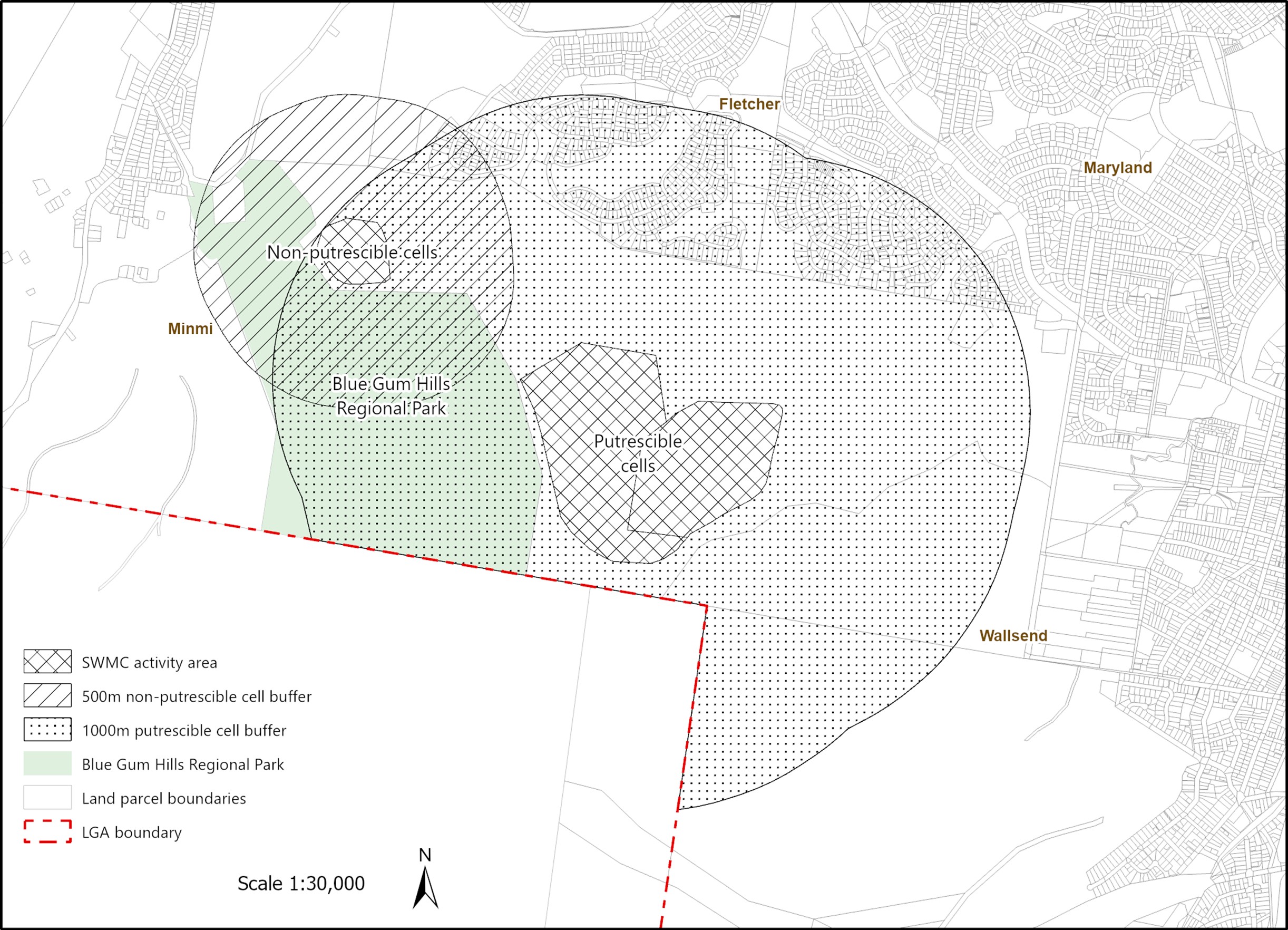 Figure D1.03: Summerhill Waste Management Centre Buffer – Residential
 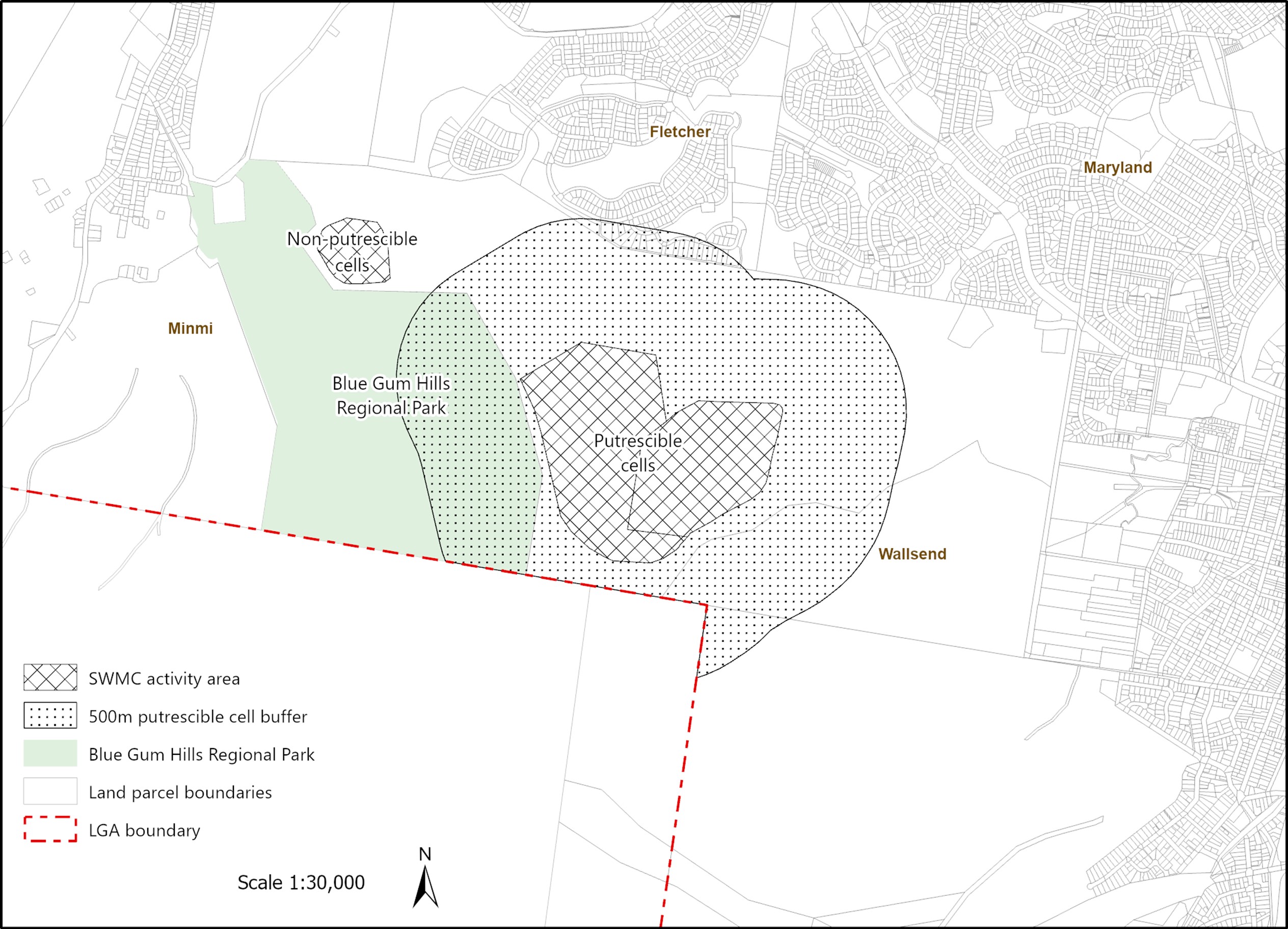 Figure D1.04: Summerhill Waste Management Centre Buffer – Non-residential
 Objectives
- Ensure developments have adequate services, including water for domestic and firefighting purposes, to cater for future developments and their occupants.
- Enable installation, maintenance, and augmentation of services in a cost-effective manner and with minimal impact on the environment and community.
- The location of services minimises visual impact.
Controls (C) | Acceptable solutions (AS) | Explanatory notes |
C-1. Essential services are provided to each lot, including the delivery of:
|
| Early consultation with CN's Waste Services team is encouraged to guarantee satisfactory waste service arrangements can be accommodated within the subdivision design. On-site disposal of sewerage will only be considered when connection to Hunter Water Corporation mains is not feasible. |
C-2. Use Ausgrid Style 2 standard light poles (galvanised), as amended/ updated/ renamed. If a developer proposes a more decorative style of light pole, a non-refundable payment may be required, at the rate of the unit cost for one pole and luminaire for each 10 units or part thereof. |
|
|
C-3. All utility services are provided underground. | AS-1. Where overhead electricity wiring exists in established areas this standard may be varied to provide for reasonable connection to the existing system. | For services installation, refer to the Model Agreement for Local Councils and Utility/Service Providers and the Guide to Codes & Practices for Streets Opening. Copies of detailed construction plans, approved by the respective utility provider, submitted before a Construction Certificate is issued for subdivision work. |
C-4. The location of utility services does not adversely affect the viability of significant vegetation and waterways. | AS-1. Utility services are co-located within road reserves. AS-2. Waterway crossings are minimised. AS-3. Locate utilities to avoid habitat fragmentation and imposing vegetation maintenance on adjacent native vegetation and trees. |
|
C-5. Maintain adequate buffers between utility services and houses to protect residential amenity and health. |
|
|
Objectives
- Ensure clear ownership and easements are established for battleaxe handles and stormwater drainage.
- Ensure appropriate management is established for battleaxe handles.
- Facilitate greater diversity in housing choice, form, and density.
- Provide safe and convenient vehicular and pedestrian access with adequate manoeuvring areas.
- Ensure the amenity of the lot and neighbouring lots is not compromised.
Controls (C) | Explanatory notes |
C-1. Vehicle access, where shared between proposed lots, incorporates appropriate right of carriageway to ensure a clear legal standing. The right of carriageway includes any turning areas and visitor parking bays where appropriate. |
|
C-2. Access handles do not support more than two lots. |
|
C-3. The minimum width of the access handle for a domestic battleaxe lot is 3m. |
|
C-4. The minimum width of an access handle in a new residential site is 4m. |
|
C-5. An access handle for a residential battle-axe subdivision complies with AS2890.1 including not exceeding a maximum gradient of 25%. |
|
C-6. An access handle for a commercial or industrial battleaxe subdivision complies with AS2890.2. |
|
C-7. Access handles of a battleaxe allotment are not a dominating independent or cumulative feature within the streetscape. |
|
C-8. Access handles of battle-axe lots ensure vehicles enter and leave the site in a forward direction. |
|
C-9. Battleaxe subdivision design provides for satisfactory provisions for Fire and Rescue NSW appliance access and water supply. | Refer to Fire and Rescue NSW publication 'Access for fire brigade vehicles and firefighters.' |
C-10. Battleaxe subdivisions that have frontage to a laneway provide satisfactory vehicular and pedestrian access; waste collection; addressing and mail delivery. | Refer to Section C11 - Development adjoining laneways. |
C-11. The maximum length of the access handle for a battleaxe lot is 50m. Provide passing bays in accordance with Australian Standards. |
|
C-12. The pavement within the access handle and associated drainage (in accordance with Section C2 Movement Networks) is constructed from the road to the usable part of the lot prior to release of the subdivision certificate. |
|
Objectives
- Ensure community title subdivisions meet the needs of end users/owners.
- Ensure all shared facilities or areas common to the scheme are suitably nominated.
- Provision is made for ongoing effective and efficient management of Association land.
Controls (C) |
C-1. Communal open areas are designed to meet user needs and determined by:
|
C-2. Appropriate vehicular access is provided having regard to the road hierarchy of the proposed movement network. |
C-3. Essential services with separate meters are provided to all proposed lots, including common areas where necessary. |
C-4. Where community title is proposed that includes environmental lands or riparian zones:
|
| Note: Sub-sections 8 - 11 also apply. |
Objectives
- Prevent sites from becoming isolated and unable to be developed in accordance with LEP 2012.
Controls (C) | Explanatory notes |
The following controls apply only to subdivisions in residential zones | |
C-1. Where development is proposed to cross lot boundaries, consolidation of the subject lots will be required. | Plans may be required showing potential building footprint and open space for constrained sites to ensure that relevant solar access requirements can be achieved. |
Objectives
- Ensure subdivision works meet all necessary standards.
Controls (C) | Explanatory notes |
| Refer to CN's Subdivision, Stormwater and Urban Forest Technical Manual/s, as amended. |
Objectives
- Ensure lots are serviced prior to titles being registered with NSW Land Registry Services.
Controls (C) | Explanatory notes |
C-1. Bonding for completion of minor works to allow the issuing of the subdivision certificate is only accepted where it is demonstrated such works are not required to service proposed lots that may be transferred into private ownership. | Bonds must be either cash or guarantee by a recognised financial institution. |
C-2. Bonding of work to be completed on land that will continue to be privately owned after subdivision is generally not supported. | |
C-3. Bonds may also be associated with defect liability periods or on-going maintenance works. |
Objectives
- Ensure subdivision and consolidation of land involving a heritage conservation area are commensurate with the area's heritage significance and desired future character, and conserve the important characteristics of the subdivision pattern and allotment layout, streetscape character and notable features of the place.
- Ensure subdivision and consolidation of land involving a heritage item are commensurate with the heritage significance of the item, and conserve the important characteristics of the subdivision pattern and allotment layout, streetscape character and notable features of the place.
- Ensure that subdivision and consolidation of land involving a heritage item are appropriate with the setting of a heritage item.
- Ensure that subdivision and consolidation of land involving a heritage item maintain an appropriate curtilage to conserve the heritage significance of the item.
- Allow for the interpretation of the original subdivision pattern in any development proposal.
Control (C) | Acceptable solutions (AS) | Explanatory notes |
C-1. The resultant allotment and building spacing (e.g. frontage widths, side and front boundary setbacks) maintain the fine grain pattern of development and rhythm of buildings in the streetscape or heritage conservation area. |
| Subdivision applications for land containing heritage items or for land in the vicinity of heritage items require adequate plans showing existing contours or levels, buildings, works, trees, and site features (e.g. dams), future building envelopes and the siting and setbacks of any proposed buildings. The heritage impact statement should demonstrate satisfaction that the:
Refer to Section E1 Built and Landscape Heritage and E2 Heritage conservation areas. |
C-2. Retain significant features such as buildings, archaeological sites, and outbuildings that contribute to the heritage significance of the item or the pattern of development in the heritage conservation area. |
|
|
C-3. Subdivision and consolidation of land in a heritage conservation area conserve the significant features of the precinct, the streetscape character and setting of contributory buildings. | AS-1. Vistas and views of heritage items, especially the principal elevations of buildings are not interrupted or obscured. AS-2. Future development does not visually disrupt the setting and impact on the presentation of the heritage item or contributory building in a heritage conservation area. |
|
C-4. Subdivision and consolidation of land involving a heritage item or property in a heritage conservation area allow for the original pattern of the subdivision to be interpreted in any development proposal. |
|
|
C-5. Retain the landscape quality of the streetscape or natural landscape in heritage conservation areas, the setting of the heritage item, and a satisfactory curtilage, including important landscape and garden elements such as any original garden areas, large trees, and other features which contribute to the significance of the heritage place. |
|
|
C-6. The subdivision does not demolish existing building stock that contributes to the heritage significance of the item, or rearrange vehicular access or car parking (on or off the site of the proposal), that adversely affects the streetscape in heritage conservation areas or the significance of any heritage item. |
|
|