Section D5 Industrial
Industrial land uses are important employment generators and economic contributors. The nature of these uses is often associated with impacts caused by noise or traffic, or environmental amenity for adjacent and nearby sensitive land uses. This is particularly relevant where historical development land has led to residential and industrial uses occurring close to each other.
The function of industrial land uses, is often prioritised over its presence, including the design of buildings and streetscape appearance. However, these typologies are a strong part of the urban fabric and the sites of public interactions. It is therefore important that amenity and aesthetics are considered in conjunction with the functioning of the site.
Development of this nature often has specific challenges such as stormwater from large areas of impervious surfaces and roofing, pollutants from onsite activities, noise, waste, access and servicing. Notwithstanding, there are significant opportunities available to realise sustainability benefits, including:
- reducing energy consumption through careful site and building design
- increasing water efficiency through stormwater capture and reuse, and/or the use of water sensitive urban design principles.
Overall, the development is to be sited and designed to be environmentally sustainable, minimise land use conflict and operate under appropriate environmental mitigation measures to manage waste and minimise air, water and noise pollution. Development is to be compatible with the scale, form, design, colour, height, materials, setbacks and landscaping of the surrounding area.
This section applies to all land zoned:
- E3 Productivity Support
- E4 General Industrial
- E5 Heavy Industrial
- SP1 Special Activities
For development involving heritage items or heritage conservation areas identified under Newcastle Local Environmental Plan 2012 (LEP 2012), a merit assessment will be undertaken to ensure the outcomes sought are balanced with heritage conservation outcomes.
The following sections will also apply to development:
The following sections may also apply to development:
- B1(a) Flood management - pre 2019 flood studies
- B1(b) Flood management - post 2019 flood studies
- B2 Bush fire protection
- B3 Mine subsidence
- B4 Aboriginal cultural heritage
- B5 Historical archaeology
- B7 Land contamination
- C1 Traffic, parking and access
- C3 Vegetation preservation and care
- C4 Stormwater
- C5 Soil management
- C6 Waste management
- C7 Safety & security
- C8 Social impact
- C9 Advertising and signage
- C10 Street awnings and balconies
- C11 Development adjoining laneways
- C12 Open space and landscaping
- D1 Subdivision and lot consolidation
- D2 Single dwelling and ancillary development
- D3 Residential development
- D4 Commercial
- D5 Industrial
- D6 Community services
- D7 Sex industry establishments
- E1 Built and landscape heritage
- E7 Wickham
- E9 Black Hill employment area
- NSW Industrial Noise Policy, 2000, NSW Environment Protection Authority
- Noise Policy for Industry, 2017, NSW Environment Protection Authority
- Promote the efficient and economic use of industrial resources by ensuring proposed development is appropriate for industrial areas.
- Outline requirements for development on sites zoned SP1 (Special Activities) under State Environmental Planning Policy (Transport and Infrastructure) 2021 and located outside the Port of Newcastle Lease Area.
- Ensure development has minimal impacts on adjacent sensitive land uses.
- Encourage industrial development and employment generating uses that operate in a functional, safe and environmentally responsible manner.
A word or expression has the same meaning as it has in LEP 2012, unless otherwise defined.
Development category | Application requirements | Explanatory notes |
All applications that include the erection of a new structure or the extension of an existing structure may require a 3D model. | The format should be compatible to that used by City of Newcastle (CN). Format specification requirements for the model can be provided by CN's Geospatial Information Services team. | The 3D Model should be used to illustrate the following information:
|
Development that adjoins or is located near land zoned and for residential use. | Details of the proposed operation, including, but not limited to:
|
|
All development applications (DA) proposing a change to the built form that will impact:
For properties adjoining land zoned for residential use, or land used for residential purposes where sunlight access to windows of living areas, or private open space may be impacted. | Shadow diagrams are to be supplied that graphically indicate how the requirements in sub-section 10.0, 11.0 and 15.0 of this section have been achieved. Shadow diagrams must show the effect in plan and elevation view of the existing and proposed overshadowing for June 21 at hourly intervals between 9:00am and 3:00pm. The shadow diagrams must:
|
|
Any development requiring an acoustic report or a noise impact assessment. | An acoustic report or noise impact assessment is warranted when a noise-producing development is proposed near noise-sensitive areas or, conversely, when a noise-sensitive development is proposed in a noisy area. An acoustic report should:
Ensure any recommendations concerning acoustic attenuation are feasible and can be practically implemented. | A noise-sensitive development may include but is not limited to residential accommodation, educational establishments, early education and childcare facility, health services facility, place of public worship or the like. More guidance can be found in the Noise Guide for Local Government, 2023 (NSW Environment Protection Authority) and, Approved Methods for the Measurement and Analysis of Environmental Noise in NSW, 2022 (NSW Environment Protection Authority). |
An application for development, including a change of use involving building work. | An access report identifying the relevant matters to be addressed at the construction certificate stage, in circumstances where access constitutes a substantive public interest aspect of a proposal. Access reports should be prepared by a person who is a suitably qualified access consultant, such as a person who is appropriately accredited by the Association of Consultants in Access Australia Inc. | The Disability (Access to Premises – Buildings) Standards 2010 applies to any part of a building impacted by the application for a change of use. This section does not require anything beyond the standard, but does require information on how the standard will be met through the building design in accordance with these application requirements. There may also be other standards under the Disability Discrimination Act 1992 relevant to the public interest assessment of a proposal, such as the Disability Standards for Education 2005. |
An application for a change of use not involving building work. | An access report to consider access matters, in circumstances where access constitutes a substantive public interest aspect of the proposal. Access reports should be prepared by a suitably qualified access consultant, such as a person who is appropriately accredited by the Association of Consultants in Access Australia Inc. | A change of use not involving building works may generate public interest considerations relevant to the assessment of a DA, including in circumstances where it is apparent that a building may not comply with the access requirements of the Building Code of Australia. |
Objectives
- Ensure adequate area is available at the street frontage to accommodate satisfactory landscaping, access, parking and manoeuvring of vehicles.
- Reduce the visual impact of development on the streetscape.
- Provide a buffer between adjoining residentially zoned land, or land currently used for residential purposes, reducing adverse impacts on surrounding land uses and residential amenity.
Controls (C) | Explanatory notes |
C-1. Development is setback 5m from the front property boundary, however, this setback may be reduced by up to 50% for half the width of the site, provided that:
| Within established areas consideration will also be given to existing setbacks, particularly within the E3 Productivity support zone.
|
C-2. Nil setbacks to side and rear boundaries are permitted where abutting existing industrial development. | Side and rear boundary setbacks may be required to achieve minimum landscape area controls as prescribed in Section C12 Open Space and landscape. |
C-3. On sites of 10,000m2 or more, buildings and external work and storage areas are setback a minimum of 6m from side and rear boundaries. |
|
C-4. The minimum setback from any secondary frontage, including a lane, is a minimum of 2m. This includes storage areas. |
|
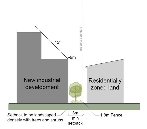
C-5. The minimum setback to residentially zoned land, or land currently used for residential purposes is 3m. This setback is increased by 1m for every additional metre above 9m in building height. The setback is to be densely landscaped with trees and shrubs, which at maturity will screen the development from residential land refer Figure D5.01. |
|
C-6. Variations to a setback for development that has more than one road frontage will be considered on merit, taking into account the following:
|
|
Objectives
- Promote development that is functional and attractive in the context of its local environment through appropriate design.
- Ensure development is sympathetic with the streetscape character and amenity of any adjoining residential precinct.
- Any proposed building or proposed alterations and additions to an existing building are to minimise and ameliorate any potential adverse impacts on amenity, noise privacy or overshadowing on any adjoining residential zoned land.
- Provide awareness of the obligations under the Commonwealth's Disability Discrimination Act 1992.
- Promote lot consolidation and ensure development does not result in isolated sites.
Controls (C) |
C-1. Buildings meet a high standard of building design to achieve a suitable level of visual and environmental quality. Attractive building design can, in most cases, be achieved simply and at comparatively low cost, and applicants are encouraged to consider variations in fascia treatments, roof lines and selection of building materials to achieve an attractive design. Design quality is determined having regard to the following:
|
C-2. Development is not to result in the creation of an isolated site that could have been developed in compliance with the relevant planning controls. Appropriate documentary evidence to demonstrate that a genuine and reasonable attempt has been made to purchase an isolated site based on a fair market value. |
C-3. Where amalgamation of the isolated site is not feasible, applicants will be required to demonstrate that an orderly and economic use and development of the separate sites can be achieved. |
C-4. The development of existing isolated sites is not to detract from the character of the streetscape and is to achieve a satisfactory level of amenity including solar access, visual and acoustic privacy. Development of existing isolated sites may not achieve the maximum potential, particularly height and floor space ratio, and will be assessed on merit. |
C-5. Where adjacent sites are developing concurrently, site planning options for development as an amalgamated site are to be explored. |
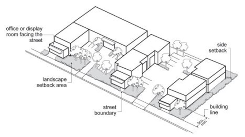 Figure D5.02: Street address and front setback Figure D5.02: Street address and front setback |
C-6. All fencing in industrial developments is constructed of palisade or decorative open style metal type fencing with a maximum 1.8m height. |
C-7. The use of sheet metal fencing or chain wire fencing on the front property boundary is not allowed. |
C-8. All front entry gates are constructed to swing inwards into the site or slide across the frontage at all times. |
C-9. Masonry retaining walls along the street frontage area restricted to 600mm in height. |
C-10. Palisade or other decorative open metal type fencing may be erected on top of the masonry wall provided the total height of the masonry wall and fence is a maximum 2.4m in height. |
C-11. An application for development including a change of use is to provide an access report in accordance with the application requirements above. |
Objectives
- Protect the amenity of adjoining residentially zoned land and uses.
- Ensure the use and development of industrial land minimises any adverse amenity, noise, overshadowing and privacy impacts to surrounding residentially zoned land and uses.
- Encourage a development layout, design and operation that appropriately manages land use conflicts.
Controls (C) | Explanatory notes |
C-1. A development proposal that adjoins or is located within proximity to residentially zoned land, or land currently used for residential purposes, must demonstrate compatibility with surrounding uses when considering the following:
Refer to Figure D5.03. | In determining a DA in industrial zones, the effect the proposal will have on the existing and likely future amenity of the neighbourhood is to be considered. The level of amenity for dwellings located on industrial land may be given less consideration than dwellings located on residential zoned land. High-intensity noise generating industries are not favoured close to residential areas. 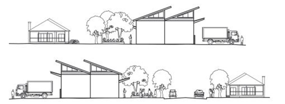 Figure D5.03: Buffer provided from noise generating activities to residential areas |
Noise C-2. Sources of noise such as garbage collection deliveries, plants and machinery, parking areas and air conditioning plants are sited away from adjoining residential properties, wherever practicable, and screened by walls or other acoustic treatments. |
|
C-3. Noise sources impacting residential habitable areas will need to be adequately addressed to ensure appropriate internal noise levels are achieved with respect to appropriate legislation, guidelines and standards. This may require applicants to obtain an acoustic report or a noise impact assessment from an appropriately qualified and experienced acoustic engineer to support their application. | Further information can be found in sub-section 7 Application requirements. |
Light spill C-4. Lighting is designed or treated to not cause light spill onto adjoining residentially zone land. | A curfew may be imposed on the operation of illuminated signage where continuous illumination may adversely impact the amenity of adjoining dwellings. |
Privacy C-5. Building siting, window location, communal open space and fencing are designed and located to maximise privacy to adjoining residentially zoned land and uses. |
|
C-6. Provide privacy screens where the distance from the window to a boundary to adjoining residentially zoned land is:
|
|
Solar access C-7. Development proposals adjoining residentially zoned land, or land currently used for residential purposes maintain at least:
Where these requirements cannot be met, the development proposal must not result in additional overshadowing of these areas. |
|
Objectives
- Provide outdoor areas that enhance the amenity of a development, allowing adequate communal outdoor space for employees and providing sunlight and shade.
Controls (C) | Explanatory notes |
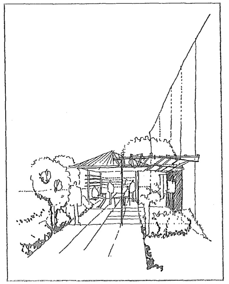
C-1. Development with a floor area greater than 500m² or with a site area greater than 2000m² provides open space facilities on site for staff which includes:
Refer to Figure D5.04. |
Figure D5.04: Open space facilities for staff |
C-2. In locating communal areas, consideration is given to the outlook, natural features of the site, and neighbouring buildings. |
|
C-3. Communal areas receive a minimum of two hours direct sunlight between 11am and 3pm on 21 June. |
|
Objectives
- Ensure open storage and work areas are suitably screened from public view.
| Controls (C) |
C-1. Where any work or storage of materials is proposed to be undertaken outside the confines of a building, full details of those parts of the site to be so used, and of the materials to be stored, are provided with the application. |
C-2. Approved open work and storage areas are located at the rear of industrial developments and screened from view by landscaping and screen fencing. |
C-3. Any screen fencing is constructed of masonry materials or pre-coloured metal cladding, having a minimum height of 2m. |
C-4. The perimeter of all approved storage areas is landscaped. |
Objectives
- Provide for the design of loading and servicing areas in a functional and aesthetically pleasing manner.
Controls (C) | Explanatory notes |
C-1. All loading and servicing areas are located to the side or rear of buildings and effectively screened from any street frontage, adjoining buildings and residential areas. |
|
C-2. Each individual allotment provides sufficient on-site loading facilities to accommodate its activities within the allotment. All loading movements, including turnaround areas, are accommodated within allotments. | Sharing of loading facilities and manoeuvring areas between sites will be considered on merit. |
C-3. Loading docks are positioned so they do not interfere with visitor and employee parking spaces and to ensure delivery vehicles do not stand on any public road, footway or laneway. |
|
Objectives
- Ensure adequate provision is made for on-site car parking and for employees and visitor's vehicles.
- Create attractive landscaped car parking throughout the development.
- Maximise opportunities for walking and cycling and where possible.
Controls (C) | Explanatory notes |
C-1. Car parking provided on site in accordance with the requirements of Section C1 Traffic, parking and access. |
|
C-2. Off-street parking is provided behind or at the side of the building area. |
|
C-3. Heavy and light traffic movements are to be separated. |
|
C-4. All vehicles are able to enter and leave the site in a forward direction. |
|
C-5. Development is to provide footpaths for the full width of any site frontage. Where the proposed footpath will adjoin and connect to an existing or approved footpath on an adjoining site, the width of the proposed footpath is to match this footpath width. See C2 Movement networks for detail. | As per Section C2 Movement networks, when determining the requirement for footpaths, considerations by CN may include, but are not limited to the following:
For more intensive developments, it may be a CN requirement to extend footways beyond the site frontage such as to connect to public transport or nearby services to support the development. |
Objectives
- Ensure development retains reasonable levels of solar access to solar panels on neighbouring properties.
Controls (C) | Acceptable solutions (AS) | Explanatory notes |
C-1. Consideration must be given to neighbouring properties’ solar panels and the loss of sunlight to these panels as a result of any development proposal, having regard to the performance, efficiency, economic viability and reasonableness of their location. | AS-1.Where reasonably practicable sunlight to any existing solar panels should not be reduced to less than two hours between 9am and 3pm on 21 June. |
|
The following controls apply to all development within ‘Steel River’ as identified on Map D5.05. If there is an inconsistency between a control under this part and elsewhere within DCP 2023 this part will take precedence to the extent of the inconsistency
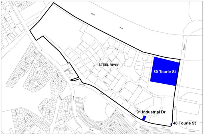 Map D5.05: Steel River
| Note: 80 Tourle Street (Lot 1 DP874109) (former EMD Plant), 48 Tourle Street (Lot 2 DP523584) and 91 Industrial Drive (Lot11 DP842850) as shown on the map above are not part of the Steel River precinct (according to the Strategic Impact Assessment Study (1998)) and are therefore exempt from the area specific controls in 17.0 Land in Zone E4 General Industrial 'Steel River', thus the general industrial development controls apply. Please consult with City of Newcastle (CN) if you are unsure about the controls that apply to these sites. |
Objectives
- Identify special controls applying to 'Steel River.'
Controls (C) | Explanatory notes |
C-1. The consent authority will not grant consent to the carrying out of development on land to which this part applies unless:
| Strategic Impact Assessment Study: The study titled ‘Strategic Impact Assessment Study’ concerning land at Tourle Street and Industrial Drive, Mayfield - the Steel River Project, February 1998, approved by CN, a copy of which is available on the CN website. Environmental envelope - all the requirements set out in Part D of the ‘Strategic Impact Assessment Study’, and includes (without limitation) the requirements relating to the following:
|
The following additional controls apply to development of land zoned SP1 (Special Use) under the State Environmental Planning Policy (Transport and Infrastructure) 2021 located outside the Port of Newcastle Lease Area and shown as applicable in Map D5.06. If there is an inconsistency between a control under this section and elsewhere within DCP 2023, this section will take precedence to the extent of the inconsistency.
-2021.jpg) Map D5.06: Land identified under State Environmental Planning Policy (Transport and Infrastructure) 2021
Map D5.06: Land identified under State Environmental Planning Policy (Transport and Infrastructure) 2021 Objectives
- Ensure safe and effective access is provided for land zoned SP1 (Special Use) under State Environmental Planning Policy (Transport and Infrastructure) 2021 and located outside of the Port of Newcastle Lease Area.
- Ensure that legal access is provided to all land zoned SP1 under State Environmental Planning Policy (Transport and Infrastructure) 2021 and located outside of the Port of Newcastle Lease Area.
Controls (C) | Explanatory notes |
C-1. Vehicular access to a development is provided by a road other than Industrial Drive, Cormorant Road or Tourle Street. | Industrial Drive, Cormorant Road and Tourle Street are classified roads. Any openings to these roads require approval from Transport for NSW. |
C-2. If access is only available from these roads, a single access point is located so that the safety, efficiency and ongoing operation of the road is maintained. Any other existing access points are to be closed. |
|
C-3. Where access to a site is via roads managed by the operator of the Port of Newcastle shown in Map D5.05, evidence the operator has given consent to use the road is submitted with the DA. | Port of Newcastle Lease Area means land identified as “Port of Newcastle Lease Area” on the Lease Area Map contained in the State Environmental Planning Policy (Transport and Infrastructure) 2021. |
C-4. Where work, such as a new or reconstructed driveway crossing, is proposed within a road reserve of a road managed by the operator of the Port of Newcastle shown in Map D5.05, the consent of the operator to lodge the DA is required. |
|
Objectives
1. Ensure safe and legal methods of stormwater disposal are provided for land zoned SP1 (Special Use) under the State Environmental Planning Policy (Transport and Infrastructure) 2021 and located outside of the Port of Newcastle Lease Area.
| Controls (C) |
C-1. Where stormwater is to be discharged via a stormwater system managed by the operator of the Port of Newcastle, the DA includes evidence that the operator has given consent to the use of the stormwater system. |