Section E12 Lingard Hospital Precinct
The Lingard Hospital Precinct (Hospital Precinct) is within the suburb of Merewether and is situated approximately three kilometres south-west from Newcastle CBD. The Hospital Precinct offers a comprehensive range of specialities and on-site cardiac, medical, surgical and allied health services.
This section applies to all land mapped as hatched on Map 1 (bounded by Lingard Street, Merewether Street, Hopkins Street and Tye Road).
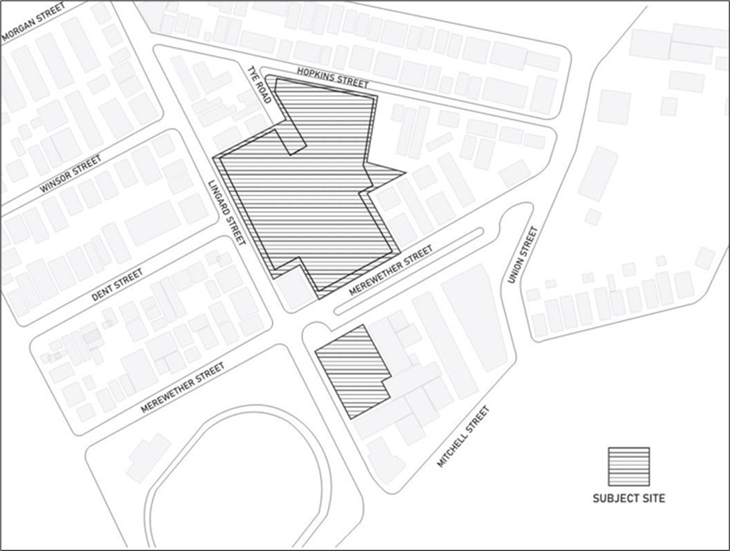 Map 1: Lingard Hospital Precinct Site
Development (type/s) to which this section applies
This section applies to all development applications for health services facilities.
The following sections will also apply to development:
The following sections may apply to development:
- B1(a) Flood management - pre 2019 flood studies
- B1(b) Flood management - post 2019 flood studies
- B3 Mine subsidence
- B4 Aboriginal cultural heritage
- B5 Historical archaeology
- B6 Urban heat
- B7 Land contamination
- C1 Traffic, parking and access
- C3 Vegetation preservation and care
- C4 Stormwater
- C5 Soil management
- C6 Waste management
- C7 Safety & security
- C8 Social impact
- C9 Advertising and signage
- C10 Street awnings and balconies
- C11 Development adjoining laneways
- C12 Open space and landscaping
- C13 Liveable housing
- E1 Built and landscape heritage
Associated technical manual/s
- Nil
Additional information
- Nil
- Deliver quality and ensuring design outcomes that are responsive to place and context.
- Manage surrounding amenity and the environmental impacts of development.
- Ensure development is connected to the street and provides a safe environment for visitors and workers.
- Improve the integration of green infrastructure and sustainability outcomes for development.
- Deliver improved movement outcomes through better connectivity and transport solutions.
- Heritage is promoted and celebrated appropriate to the level of heritage significance.
The original Lingard Hospital is located at 23 Merewether Street, Merewether, situated within the local government area (LGA) of Newcastle. A recently completed expansion of the health precinct exists across the street at 8 Lingard Street, Merewether. There is a potential to expand the health precinct to include an adjoining site at 27 Hopkins Street, Merewether.
The site is located within the suburb of Merewether and is situated approximately three kilometres south-west from the high street (Hunter Street) of Newcastle CBD. Merewether is dominated by a low density residential land uses for the majority of the suburb and is bordered by medium density residential development to the north where it meets the commercial core of The Junction precinct, approximately 450 metres from the site.
This original and principal Lingard Hospital premises is situated on land surrounded by residential uses zoned R3 Medium Density Residential, comprising single and two-storey residential built form. The recent expansion of the health services facility opposite the primary Lingard Hospital premises is sited amidst a solitary mixed business and warehouse block, zoned B5 Business Development, encompassing predominantly two-storey employment uses and built form.
In March 1971, consent was granted for construction of a single storey private hospital, with 106 beds. The Lingard Hospital precinct has continued to grow, expand and adapt to the needs of the community, today presenting a large staff across a range of speciality medical sectors. Since 2020, the Lingard Hospital has operated two distinct precincts, with investigations undertaken to expand into a third precinct. These have been identified through analysis of current land use and character, and consideration of the envisaged future development, see Map 2.
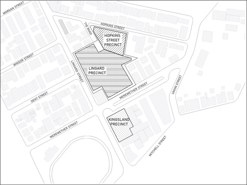 Map 2: Precincts
 Lingard precinct
The Lingard Precinct is the primary and original Hospital Campus where the majority of the Lingard services are located and provided. This Precinct has frontages to the south-east on Merewether Street and south-west on Lingard Street, and rear lane access on the north side via Tye Road. The block shape is irregular, sharing boundaries with residential lots. The allotment is almost entirely occupied with the hospital structure. Due to the age of the existing hospital, the aim for this precinct is renewal of facilities.
Kingsland precinct
The Kingsland Precinct was first established in 2016, with consulting suites completed in 2020 and is currently used for day surgery, with limited health consulting rooms. The Precinct has frontages to the north-west on Merewether Street and south-west on Lingard Street. The block is roughly rectangular, sharing boundaries with three neighbouring commercial allotments. The allotment is entirely occupied by the two-storey building structure. Substantial carparking exists in the basement levels. Due to recent development activity directly north-east of this Precinct, opportunities to expand the Kingsland Precinct are likely limited to the south-east.
Hopkins precinct
The Hopkins Precinct is not currently occupied by a health related use and is currently occupied by a residential complex. This precinct directly adjoins the Lingard Precinct to the south and has road frontages to Hopkins Street and Tye Road. The opportunities for the Hopkins Precinct will be determined based on changing health demands in the region.
Indicative staging order of future development
Stage 1: Development to add an additional storey to Kingsland precinct
Stage 2: Development of Hopkins Street
Stage 3: Refurbishment of existing Lingard precinct Hospital
Objectives
- Development planning and design decisions are informed by a comprehensive understanding of the site and its context.
- Development planning and design is responsive to existing site conditions and surrounds.
Controls
General controls applying to all development to which this section applies
- A site analysis is submitted to the level of detail required to assess the potential impacts associated with the nature, type and scale of the development and its surroundings. The site analysis will identify the unique and specific qualities and attributes of the subject site, as well as identify the opportunities and constraints of the site and the wider area. This is to be undertaken at the local, neighbourhood and streetscape, as well as site scale to understand how the development responds to the context at the varying scales.
- The design and supporting information demonstrate how the development responds to the constraints and opportunities identified in the site analysis.
Objectives
- The proposed development is positioned and oriented on the site to minimise the impact on surrounding properties and uses.
Controls
General controls applying to all development to which this section applies
The development layout is generally in accordance with Map 3 unless an equivalent or improved planning outcome is identified as a result of the site analysis design process.
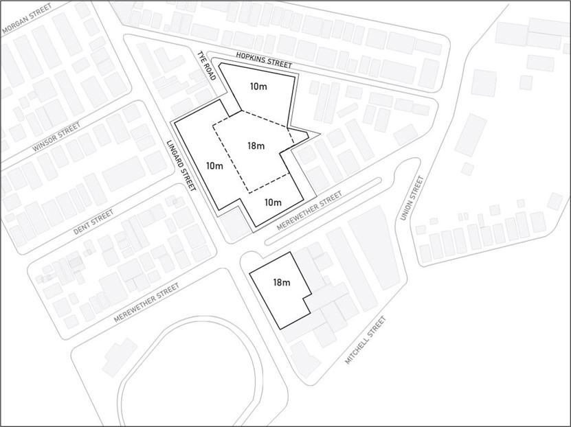 Map 3: Indicative site layout
 Objectives
- The building height is consistent with the desired scale and character of the street and locality, creates an articulated and visually interesting skyline, and provides an acceptable impact on the amenity of adjoining properties.
- Setbacks are established by the context and established urban form, ensure that built form engages with the public domain, and minimise the impact on the amenity of adjoining properties.
- Buildings and sites are designed to preserve the amenity of adjacent public open spaces.
Controls
General controls applying to all development to which this section applies
- The maximum building height is in accordance with the relevant statutory requirements and site-specific criteria.
- Setbacks to boundaries shared with residential uses, where the residential uses are within 3m of the boundary are:
- 1.5m setback up to 3m in height
- 3m setback from 3m - 6m in height, and
- 4.5m setback above 6m in height.
- For circumstances where the criteria detailed directly above does not apply, building setbacks are consistent with those shown on Map 4, Map 5 and Figure E12.01, unless an equivalent or improved planning outcome is identified as a result of the site analysis design process.
- Development does not unreasonably reduce the total area of public open space (such as Mitchell Park) that receives direct sunlight between 9am to 3pm on June 21.
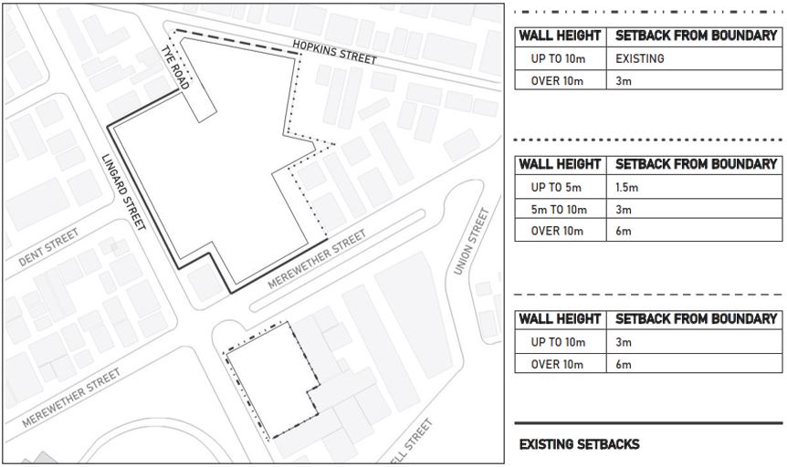 Map 4: Indicative setbacks
 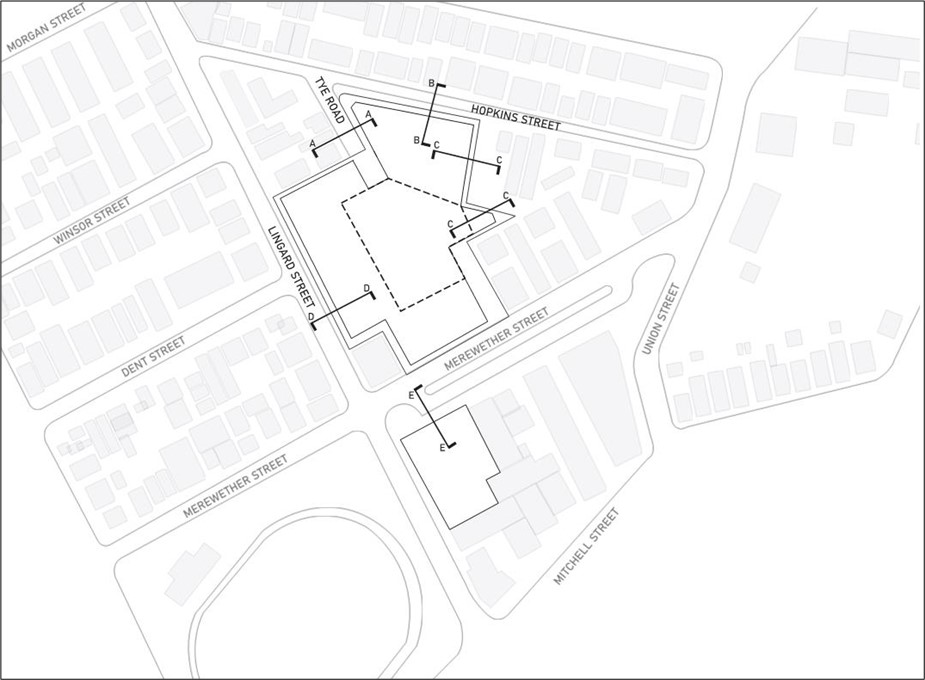 Map 5: Cross section locations
 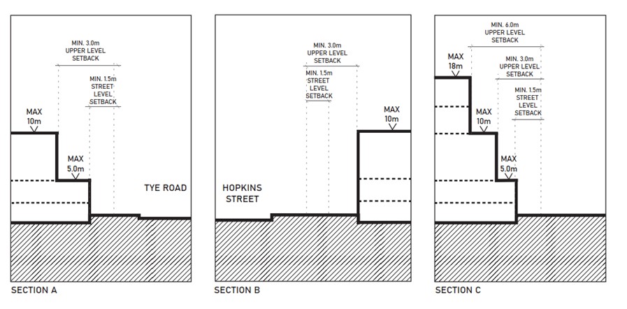 Figure E12.01: Cross sections A – C
 | Note: The built form and massing of health service facility buildings should transition in scale from the from the hospital context, down to the residential scale. |
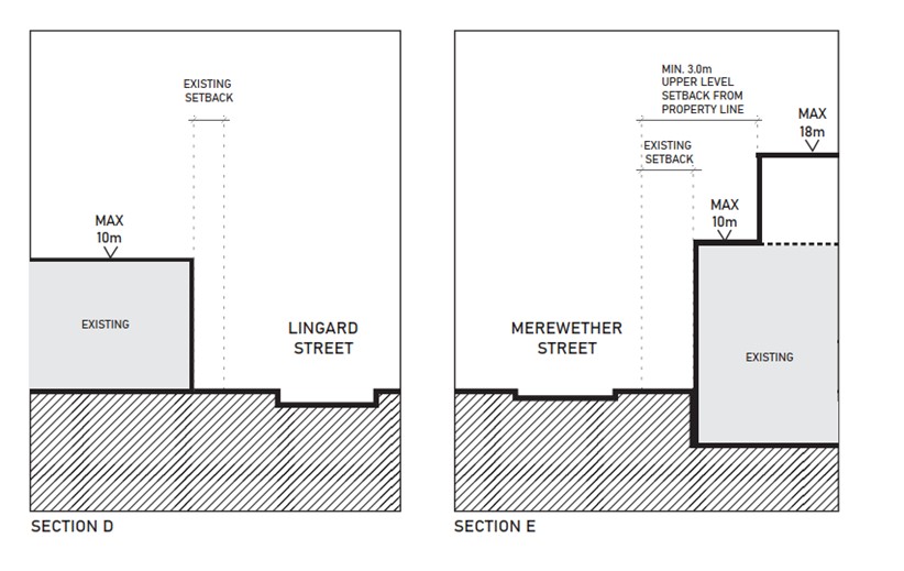 Figure E12.02: Cross sections D – E
Objectives
- Buildings and sites contribute to a finer grained urban environment through built form articulation and through site links.
- The built form and massing of buildings are designed in response to their context, considered as an ensemble of elements and allow for articulation.
Controls
General controls applying to all development to which this section applies
- Large buildings are broken up or articulated to reduce overall perceived bulk and scale, as well as provide architectural interest.
- Through site links are considered where it would provide a positive contribution to the public domain.
- Impacts on surrounding properties are minimised.
Objectives
- Architectural form is defined by a balanced composition of elements and makes a positive contribution to the urban environment.
- Plant and equipment are screened, and screening elements are integrated into the architectural design.
- Material selection contributes to the design of an aesthetically pleasing, durable and resilient building.
Controls
General controls applying to all development to which this section applies
- The design of the development exhibits good proportions and a balanced composition of elements that reflects the building’s use, its structure, and internal planning.
- The aesthetics and composition of the development are considered in relation to the surrounding buildings and context.
- Building facades display a balanced composition of elements including solid and void, fenestration, signage integration, as well as an appropriate scale and proportion to the streetscape.
- All plant and equipment is screened from view from the public domain, and any residential or mixed use areas.
- Ground level plant to be located behind the front building line and/or rooftop plant to be set back from perimeter and screened for visual privacy and to meet acoustic regulations.
- Screening of plant and equipment is to be:
- considered as a part of the architectural design and integrated into the overall design of the building, and
- a secondary preference, with primary emphasis on locating elements out of view from the public domain
- materials are robust, durable and low maintenance, having regard to the weather conditions to ensure a high quality finish that endures for the life of the building
- materials are selected for their low embodied energy and potential for future re-use or recycling
- materials are not highly reflective to avoid glare and the absorption of heat
- street walls should be articulated through colour, texture and materiality to provide scale, street definition and pedestrian interest.
Objectives
- Built form is arranged and sited to minimise impacts on neighbouring residential uses.
- Development does not unreasonably reduce the existing solar access of neighbouring residential areas.
- Acoustic Privacy is managed so that noise transfer to neighbouring residential uses is minimised through the siting of buildings and building layout.
- Visual Privacy of neighbouring residential areas is maintained through the orientation and siting of the building, and where required, screening.
Controls
General controls applying to all development to which this section applies
- Where the site adjoins residential uses, the built form steps down in scale toward the boundary shared with residential uses.
- Direct solar access is retained to habitable rooms and private open spaces of neighbouring residential uses for a minimum of 3hrs between 9am - 3pm on 21st June. Direct Solar access is defined as a minimum of 1sqm at 1m above the FFL receiving the full 3hrs of daylight.
- Noise generating uses are located away from residential areas and screened with appropriate acoustic treatment to bring noise to within statutory and/or approved levels.
- Buildings are oriented on the site to minimise opportunities for overlooking of residential living areas, and private outdoor space. Unscreened openings are located on walls not facing residential uses.
- Where overlooking is unavoidable, openings that enable a view to private spaces are to be treated to maintain the privacy of residential uses. Options may include angling openings to orient the view elsewhere, using obscure glazing to lower portions of windows, fixed external louvres/privacy screens or, fixed depth planters.
- Privacy screens are consistent with, and integrated into, the design of the building.
- Built form is arranged to prevent the total loss of prevailing winds for passive cooling for adjoining residential properties.
Objectives
- The development provides activation and passive surveillance to public streets and public open space.
- Building entries provide employees, patients, and visitors with a welcoming, accessible, entry point.
- Awnings are considered as part of the overall development and designed accordingly.
- Secondary frontages make a positive contribution to the public domain.
- Building services and essential equipment are integrated with the building design.
- Welcoming urban activation space is incorporated into the development for the enjoyment of residents, the local community and users of the development that provides relief from the urban environment and allows people to gather.
- The development does not dominate the public domain along the Hopkins Street frontage and instead responds to and complements the scale, context, streetscape character and landscape.
Controls
General controls applying to all development to which this section applies
- Active uses are located along street frontages to enliven facades. Long expanses of blank, solid and unbroken walls are avoided along street frontages.
- Clear glazed openings are provided along the street frontage to active uses behind, to provide engagement with the street, and passive surveillance of the public domain.
- Minimum 25% of any new facade facing a street may be glazed.
- Glazed facades facing a street must be low reflective glass.
- All publicly accessible external areas of the site are visible from within the building to encourage activation of building facades and to provide passive surveillance of open spaces.
- Building Entries:
- are accessible, clearly defined, inviting, and visible from the public domain
- provide weather protection
- are located on the primary frontage. Where this is not possible, they are visible from the public domain, and clearly sign posted.
- Awnings shall be provided to public access entrances and are in accordance with the relevant awning provisions contained separately within C10 Street awnings and balconies
- Frontages to secondary roads are provide an active edge to the boundary treatment, are integrated with the design and make a positive contribution to the public domain.
- Secondary frontages are articulated and modelled to provide interest along the street edge.
- Setbacks to secondary frontages are landscaped.
- Essential services and equipment required to be accessible from the public domain are located:
- away from main building entries and lobbies; and
- in services enclosures, cupboards, and doors that address the public domain and are integrated with the design of the building.
- Urban activation spaces are implemented for each precinct and are positioned in central locations, typically within front or secondary setbacks in proximity to a main entrance and partly incorporated into the road reserve.
- Urban activation spaces comprise uses or facilities such as:
- shade and tree plantings
- rain gardens
- furnishings such as seats, bins and drinking fountains
- play equipment
- lawns and paved areas
- lighting
- Wi-Fi
- public facilities
- publicly accessible art.
Objectives
- Landscaped areas provide shade, acoustic and visual buffers to main roads and adjoining residents, permeable surfaces for stormwater, and attractive additions to sites and structures.
- Trees provide shade to hardstand areas, building facades, and parking areas; reducing the heat island effect, and mechanical cooling requirements for buildings.
- Site planning minimises the impact on existing vegetation.
- Public domain is embellished with vegetation to realise the benefits of the urban forest and contribute to neighbourhood character.
Controls
General controls applying to all development to which this section applies
- Landscaped area has a minimum dimension of 1.5m.
- Larger, consolidated areas of landscaping with a minimum dimension of 3m are provided to enable greater varieties of planting, larger plants, and denser screening. Long narrow strips of landscaped area are avoided.
- Landscaped areas are located to provide the greatest benefit to the subject site, the public domain, and neighbouring properties. Landscaping is provided along boundaries adjoining residential uses including screening trees. Landscaped areas are to act as buffers to residential uses.
- Permeable paving is used in place of hardstand areas where possible to reduce stormwater runoff and overland flow.
- Local indigenous plants are favoured in the landscape design to reinforce local character and assist in the regeneration of local microclimates. Plant species selection is to accommodate local environmental conditions, particularly the exposure to strong coastal winds, salt spray and shading.
- A landscape maintenance plan is submitted and includes a schedule of maintenance.
- Declared vegetation is identified, retained, and protected. during construction.
- Locate landscaped areas and tree plantings in positions where they provide the greatest amount of shade to communal areas, building facades and roofs, parking, and other hardstand areas.
- Street tree planting is provided along Merewether Street in consultation and accordance with the relevant Council requirements.
- The existing palm tree on the corner of Hopkins Street and Tye Road is retained and protected during construction.
- A minimum four metre (4m) wide landscaped setback on Hopkins Street is established with vegetation that has a medium to long-term life expectancy retained. A three metre (3m) setback may be considered for the Hopkins Street frontage, where at least two of the following:
- retention of any declared vegetation (as specified by C3 Vegetation preservation and care) along the Hopkins Street frontage
- deep soil landscaping is provided for at least 80% of the frontage length
- a green wall is established for at least a third of the Hopkins.
- Roof gardens on buildings that provide areas for recreation and environmental benefits (such as recreation, communal space, stormwater storage/treatment, insulation or the like) are incorporated, where reasonable and feasible.
Objectives
- The movement network has a clear structure, is functional and provides for the safe, efficient and equitable movement of pedestrians, cyclists and vehicles.
- Transport and movement elements are a considered part of the overall urban design and minimise impact on the public domain, surrounding properties and the locality.
Controls
General controls applying to all development to which this section applies
- Development proposals which, in the opinion of Council, may cause significant impacts on the surrounding movement network, are supported by a Traffic Impact Study (TIS), prepared by a suitably qualified and experienced transport professional.
- Issues addressed in the TIS are to include, but not limited to:
- review of the existing and proposed traffic network, traffic operating conditions and flows
- existing car parking supply and likely demand, as well as servicing requirements
- existing trip generation and estimate of trip generation of the development
- public transport services within the vicinity of the proposed development
- impacts of generated traffic on the surrounding road network and the locality
- safety of access between the site and the adjacent road network
- pedestrian infrastructure, generation and movements
- recommended improvement works
- linkages with existing and proposed bicycle and pedestrian routes.
- The TIS will also include measures proposed to increase mode share to public transport and improve access to services.
- The TIS should be prepared having regards for the entire heath Precinct together with the proposed development. The TIS must provide traffic modelling for the local road intersections and signalised intersections and such modelling must provide cumulative post development traffic data generated by the entire Lingard Hospital Precinct (that is Kingsland, Lingard and Hopkins). The TIS should consider the impacts from the Precincts and provide recommendations for improvements and management of the local and signalised intersections.
- Development is in accordance with the relevant transport and movement criteria contained separately within C1 Traffic, parking and access and C2 Movement networks, unless an equivalent or improved planning outcome is identified as a result of the site analysis design process, TIS and/or advice from Council.
- Access and servicing of the site in accordance with Map 6 and Map 7, particularly the through link from Tye Road to Merewether Street, is subject to improved results and outcomes identified in the TIS.
- Major development of the site is to demonstrate that safe entry treatment at the intersection of Hopkins Street and Tye Road can be achieved and implemented.
- All vehicles are to enter and leave site in forward motion.
- Vehicular access is located to minimise impact on the streetscape and surrounding local context.
- Sufficient area is provided for the safe manoeuvring of large trucks and service vehicles as required for operation of the development.
- The size and layout of loading areas are appropriate for the use and ongoing operation of the development.
- Clear delineation of the loading areas is provided to ensure safe ongoing operation.
- Dedicated service vehicle circulation may be considered to ensure safe movement of pedestrian, vehicles and service vehicles.
- Major development of the site is to demonstrate that safe vehicle, pedestrian and cyclist movement at the intersection of Merewether Street and Lingard Street to the Lingard and Kingsland Precincts can be achieved and implemented.
- Provide accessible pedestrian paths from street front boundary to building entries, separated from any vehicular circulation or parking.
- Provide marked crossings where pedestrian access crosses any road or driveway.
- Provide an accessible pedestrian circulation path from all car parking areas to building entries.
- Provide dedicated circulation path, separate to any road or drive, adjacent building from carpark to building entry.
- Safe pedestrian access routes are provided to improve connectivity across the overall site and to the locality.
- Public access is restricted to areas unsafe or unsuitable for public access in the form of fencing or barriers.
- Public access is restricted to areas not visible from the public domain outside of business hours.
- Safe and legible access to staff and visitor bicycle parking is provided that is not in conflict with vehicular access and circulation.
- Provision is made for future pedestrian connections between Lingard and Kingsland precincts.
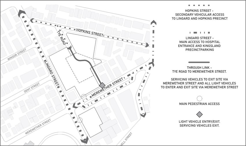 Map 6: Access
 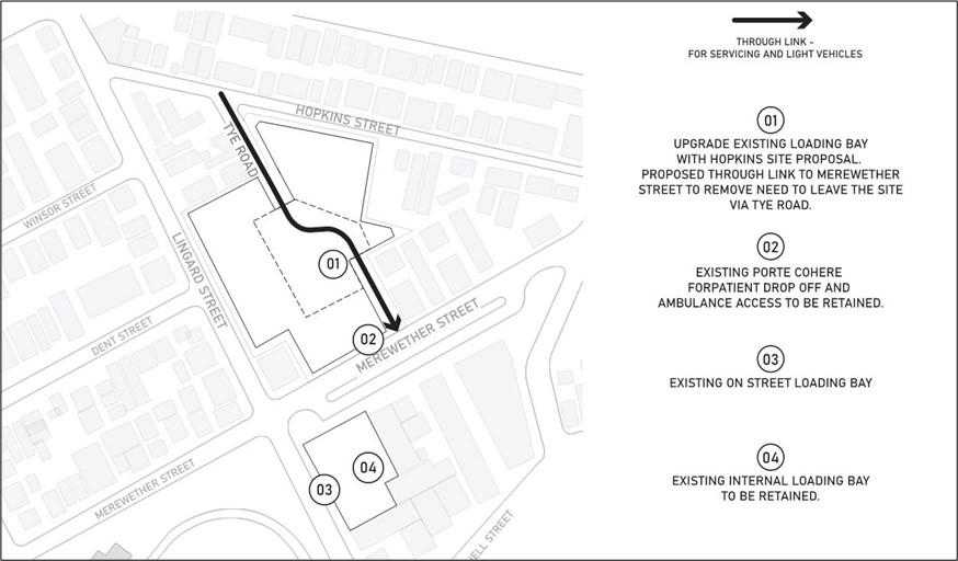 Map 7: Servicing
Objectives
- Adequate off-street parking is provided to maintain a high amenity of the adjoining street network and reduce the impact and demand for on-street parking and services.
- The visual and environmental impacts of vehicular parking are mitigated through siting, screening and landscaping to ensure that parking does not dominate the streetscape.
- Vehicular parking is utilised and managed in a functional, sustainable and equitable manner.
Controls
General controls applying to all development to which this section applies
- Development is in accordance with the relevant parking criteria contained separately within this C1 Traffic, parking and access.
- On-site parking is provided underground. Where underground parking is unachievable, at grade parking will only be considered where:
- it is predominantly set back or sleeved behind other uses; or
- it is screened, integrated into the built form and covered by upper levels of the building; or
- it is not within front building setbacks.
- Basement parking, loading areas and servicing areas are located and designed to minimise impact on the public domain and adjoining residential uses.
- On-site parking is to be self-operational and self-managed. Commercial models of parking provision and management are avoided.
- Development must demonstrate that a clear initiative and direction can be achieved and implemented for parking to be made available to staff and visitors of the site, with minimum to no cost.
- Development must demonstrate that a clear initiative and direction can be achieved and implemented for the allocation of parking spaces to the various users to assist with parking management and sustainable usage.
Objectives
- Development incorporates passive environmental design to reduce energy usage and ongoing costs.
Controls
General controls applying to all development to which this section applies
- Avoid dark or mirrored glass as means of reducing heat loading.
- North, east, and west facing glazing is shaded by external screens, louvres, or overhangs.
- Maximise thermal mass where possible in north facing rooms.
- Light coloured roofing materials with a high Total Solar Reflectance are to be used to reduce heat loading.
- Solar systems (energy/water) are encouraged to be installed on roofs to generate electricity and/or reduce energy consumption. Batteries can be used to store energy for use in the evenings.
Objectives
- Development provides workplaces or office spaces within a building with good daylight and solar access.
- Development uses natural cross ventilation to reduce air conditioning usage and provide healthy work environments.
- Ceiling heights allow for habitable areas with a high degree of amenity.
- Workplaces provide accessible open space for staff and employees.
Controls
General controls applying to all development to which this section applies
- 50% of office areas, workspaces, and consulting suites within a building are located no more than 12m from building facades providing natural daylight.
- Enclosed spaces and rooms are limited along the building perimeter to maximise natural daylight access.
- Site constraints may require reduced building depths to meet good daylight and solar access amenity.
- Where appropriate, buildings are designed with narrow floor plates and operable windows on opposing facades to allow for natural cross ventilation.
- Open windows are located away from site constraints that would lead to them not being opened or used.eg busy roads, noisy equipment, sources of odours.
- The following minimum ceiling heights are provided:
- 3.6m for ground floor retail, workspaces, areas accessible to the public, lobbies
- 2.7m for upper levels – workspaces, offices, areas accessible to the public
- 2.4m for bathrooms, kitchens, storage areas, circulation. Provide 0.5m2 per employee accommodated on the site (as defined by the BCA) as communal open space.
- Communal open space is to have a minimum dimension of 3m x 3m and receive 2 hours of direct sunlight between the hours of 9am – 6pm.
- Communal open space is shaded and furnished to accommodate seating and eating.
- Communal open space is consolidated into a well design, easily identified and usable area, and where practical co-located with landscaped areas.
- Communal open space is located and designed to benefit from daylight and natural ventilation.
- Where practical, communal open space should be located in proximity to communal kitchen facilities.
- Communal open spaces are not located where it would have a negative impact on the local context, and may be located on rooftops and balconies.
Objectives
- Development provides meaningful, considered and high quality Aboriginal and non-Aboriginal heritage interpretation at the site to improve understanding and sense of place within the community.
Controls
General controls applying to all development to which this section applies
- Heritage interpretation, appropriate to the level of heritage significance, is considered holistically across the site and coordinated accordingly across the precincts.
- A Heritage Interpretation Strategy is submitted for all major development. Heritage interpretation may include the use of historic artefacts, in-situ retention of relics, signage, artwork, public access, guided walks, electronic media, architectural design and built form or the like.
- Any Aboriginal heritage interpretation is to be delivered in consultation with relevant local Aboriginal stakeholders, considering the sensitivity of Aboriginal cultural heritage, knowledge and values.