Section E6 Fort Wallace
Fort Wallace is located within a large dune formation known as Stockton Bight. The landscape contains a number of diverse Aboriginal sites that predate the arrival of European settlers and are of extreme significance to the traditional custodians of the land, the Worimi People.
A series of Aboriginal archaeological and cultural sites are situated along the Stockton Peninsula, and are known as the 'Fern Bay Complex'. The coastal location, unique landform and diversity of environments have provided rich marine, estuarine and forest resources to the Worimi People.
Traditional knowledge records the presence of ceremonial and traditional burials sites as well as evidence of traditional Aboriginal hunting, fishing, and cultural activities. Further artefacts are likely to be present throughout Stockton Bight. The sites provide important information about the relationship and special connection Worimi people have with Stockton Bight.
Fort Wallace currently accommodates a range of disused defence buildings and infrastructure. The original fort was constructed in 1912. Two 6” guns were installed in 1915. These guns were replaced by 9” guns in 1939/40. In 1967, 130 Squadron moved to Fort Wallace, followed by the construction of new barracks in 1974. Additional construction took place on the site in 1982 to support 130 Squadron, including stores, workshop, administration, training and amenities buildings. 130 Squadron continued to use the site until the end of 1993.
The most recent use of the site was accommodation for the Australian Navy. The buildings were re-fitted as accommodation in 1996.
Defence ceased activity on the site in 2003. Fort Wallace formed part of the Commonwealth Heritage List in June 2006. The site is currently vacant, non-operational and secured.
This section applies to all land identified in Figure E6.01.
This section applies to all development within Fort Wallace.
Ensure that Fort Wallace is developed in a manner generally consistent with the Urban Design and Landscape Report – Fort Wallace, Stockton (Architectus, 2018) for the site. Refer to guideline for objectives and controls.
Land to which this section applies
This section applies to land identified in Figure E6.01.
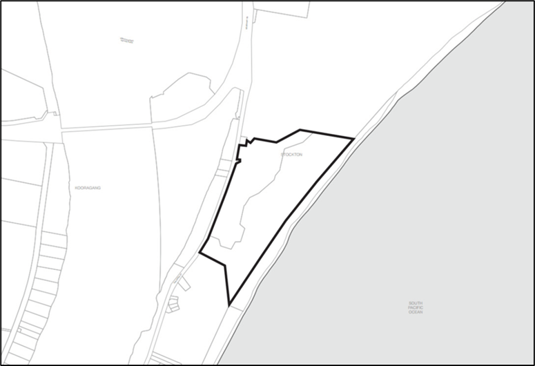 Figure E6.01: Fort Wallace
Development (type/s) to which this section applies
This section applies to all development within Fort Wallace.
Applicable environmental planning instruments and legislation
The provisions to the following listed environmental planning instrument/s also apply to development applications to which this section applies:
- Newcastle Local Environmental Plan 2012 (LEP 2012)
- State Environmental Planning Policy (Resilience and Hazards) 2021
- State Environmentally Planning Policy No 65 – Design Quality of Residential Apartment Development
- State Environmental Planning Policy (Sustainable Buildings) 2022
In the event of any inconsistency between this section and the above listed environmental planning instrument, the environmental planning instrument will prevail to the extent of the inconsistency.
Note 1: Additional environmental planning instruments may also apply in addition to those listed above. Note 2: The Environmental Planning and Assessment 1979 enables an environmental planning instrument to exclude or modify the application in whole or part. |
Related sections
The following sections will apply to development.
The following sections may also apply to development:
- B1(a) Flood management - pre 2019 flood studies
- B1(b) Flood management - post 2019 flood studies
- B2 Bush fire protection
- B4 Aboriginal cultural heritage
- B5 Historical archaeology
- B6 Urban heat
- B7 Land contamination
- C1 Traffic, parking and access
- C3 Vegetation preservation and care
- C4 Stormwater
- C5 Soil management
- C6 Waste management
- C7 Safety & security
- C8 Social impact
- C9 Advertising and signage
- C10 Street awnings and balconies
- C11 Development adjoining laneways
- C12 Open space and landscaping
- C13 Liveable housing
- E1 Built and landscape heritage
In the event of any inconsistency between this section and the above listed sections, this section prevails to the extent of the inconsistency.
Associated technical manual/s
- Austroads Publications and Guides
- Standard Drawings, Newcastle City Council
Additional information
The Urban Design and Landscape Report - Fort Wallace, Stockton (Architectus, 2018).
This section has performance criteria that explain the planning outcomes to be achieved. These have been guided by the Urban Design and Landscape Report. Accompanying the performance criteria are acceptable solutions that illustrate the preferred way of complying with the corresponding performance criterion. There may be other ways of complying with performance criteria and it is up to the applicant to demonstrate how an alternative solution achieves this.
Definitions
A word or expression has the same meaning as it has in LEP 2012, unless otherwise defined. Other words and expressions include:
- 'Fonzie flat' – is a self – contained flat above a garage.
Vision
Fort Wallace will be a sensitively designed place. It will contain diverse housing forms that are of best practice design and well-connected open spaces. Areas with special ecological, heritage or cultural values will be protected, managed and restored.
Aims of this section
- Provide appropriate development controls for the sensitive and responsive development of the site and ensure best practice design.
- Ensure development of the site embraces heritage and conserves ecological significance.
- Guide delivery of diverse housing forms on the site to serve the needs of the community.
- Protect important views through building design and location of building footprints.
- Provide well-connected and high amenity open spaces that celebrate the sites unique and special history.
Site history
Fort Wallace is located within a large dune formation known as Stockton Bight. The landscape contains a number of diverse Aboriginal sites that predate the arrival of European settlers and are of extreme significance to the traditional custodians of the land, the Worimi People.
A series of Aboriginal archaeological and cultural sites are situated along the Stockton Peninsula, and are known as the 'Fern Bay Complex'. The coastal location, unique landform and diversity of environments have provided rich marine, estuarine and forest resources to the Worimi People.
Traditional knowledge records the presence of ceremonial and traditional burials sites as well as evidence of traditional Aboriginal hunting, fishing, and cultural activities. Further artefacts are likely to be present throughout Stockton Bight. The sites provide important information about the relationship and special connection Worimi people have with Stockton Bight.
Fort Wallace currently accommodates a range of disused defence buildings and infrastructure. The original fort was constructed in 1912. Two 6” guns were installed in 1915. These guns were replaced by 9” guns in 1939/40. In 1967, 130 Squadron moved to Fort Wallace, followed by the construction of new barracks in 1974. Additional construction took place on the site in 1982 to support 130 Squadron, including stores, workshop, administration, training and amenities buildings. 130 Squadron continued to use the site until the end of 1993.
The most recent use of the site was accommodation for the Australian Navy. The buildings were re-fitted as accommodation in 1996.
Defence ceased activity on the site in 2003. Fort Wallace formed part of the Commonwealth Heritage List in June 2006. The site is currently vacant, non-operational and secured.
This section guides overall development of the site.
Performance criteria
- Street layout and hierarchy are clearly legible and intuitive to users and encourage ease of use and access for pedestrians, cyclists and vehicles.
- Streets and parking arrangements are to be informal with no kerb and gutter or formal avenue trees.
- Adequate access is provided for emergency and maintenance vehicles.
- Streets incorporate opportunities for Water Sensitive Urban Design and landscape planting of a variety of sizes and types.
- Wayfinding signage (including street names) is clearly visible and legible.
- Development of the site makes use of existing street infrastructure, including street layout to minimise disturbance of soil and vegetation.
- Street layout incorporates varied edge conditions to ensure a sensitive transition to coastal bushland areas. Excessive lengths of perimeter roads are avoided.
Acceptable solutions
- The street layout and hierarchy is provided as shown in Figure E6.02.
- All streets and lanes are designed in accordance with the street sections shown in Figure E6.03 to Figure E6.06.
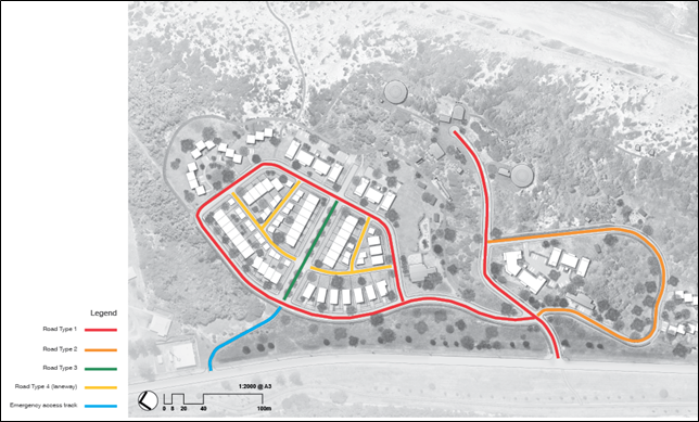 Figure E6.02: Street layout and hierarchy
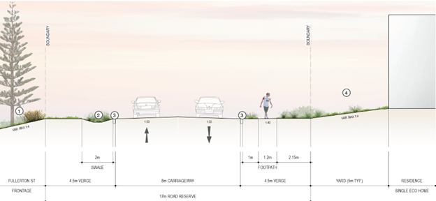
 Figure E6.03: Road type 1 typical section
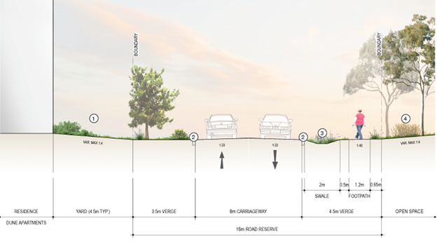
 Figure E6.04: Road type 2 typical section
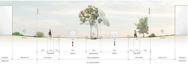
 Figure E6.05: Road type 3 typical section
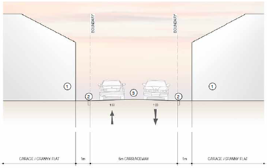
 Figure E6.06: Road type 4 typical section
 Performance criteria
- Development respects areas of high ecological and heritage significance.
- Development responds to the risks associated with coastal erosion and provides appropriate setbacks for development and infrastructure.
- A transition in dwelling form and density from the central development area to the bushland to the north and south is achieved.
- Buildings respond to site topography and step with the land form to minimise earthworks and overall scale and massing.
- Significant heritage structures are retained and development reflects a collective understanding and interpretation of the items as a group.
- A landscaped frontage is provided to Fullerton Street that complements the coastal mangroves on the opposing bank and is able to accommodate landscaped drainage features.
- The bulk and massing of buildings responds to the lot size with appropriately scaled buildings and setbacks.
- Buildings are articulated through the use of windows, balconies, materials and finishes to minimise visual bulk.
Acceptable solutions
- The development layout and building typology is provided as shown in Figure E6.07.
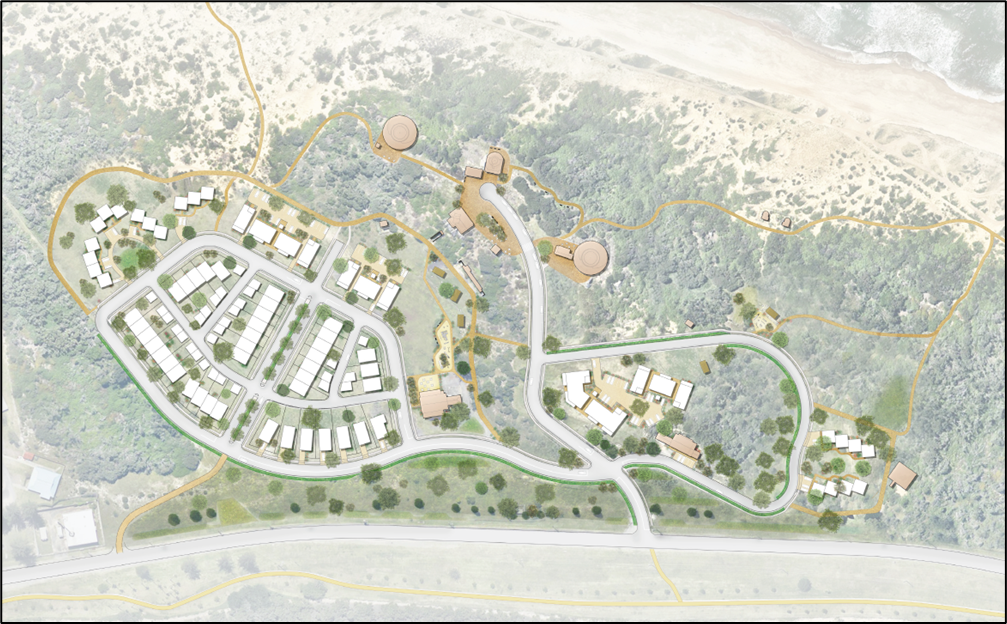 Figure E6.07: Land use and development area
This section guides development within the precincts and overall character.
Performance criteria
- Significant heritage items are positively integrated and carefully managed.
- Development provides an appropriate interface and transition to environmentally sensitive areas.
- Development incorporates a managed bushland edge to reinforce coastal character.
- Buildings are designed to touch lightly on the land and sit sensitively within the natural landscape.
- Earthworks and areas of hard surface (slab on ground construction) are minimised.
- A mix of building typologies, including smaller lot housing are provided to allow for housing choice.
- Development utilises interesting architectural forms through staggered building heights, natural materials and finishes, articulated facades, vaulted and skillion roofs and varied street setbacks where appropriate.
- Character areas respond appropriately to their unique setting.
Performance criteria
- Sufficient setbacks are to be provided to lot boundaries to allow for building separation, create a landscaped setting for buildings, reduce the visual bulk and scale of buildings and provide reasonable sharing of views.
- Delivery of consistent setbacks to ensure a high visual quality streetscape with a prevailing sense of openness.
- Development is to maintain a visual continuity and pattern to buildings and landscape elements.
- Ensure that each dwelling is afforded a degree of visual privacy through appropriate setbacks which minimise the extent of overlooking.
Acceptable solutions
- Built form and character of areas are established as shown in Figure E6.08.
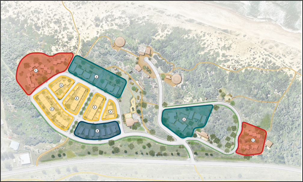 Figure E6.08: Character areas
The precinct manages the transition between urban living and lands with environmental sensitivities. The housing form is typically multi-dwelling housing that reinforces the coastal character of the site with clustered dwellings that minimise building footprint, smaller, defined private open spaces, and larger, communal areas blending seamlessly with the bushland. This area should utilise low impact fencing and native landscaping.
Housing will be in accordance with the following guidelines, unless an alternative proposal can demonstrate an improved outcome in line with the key design outcomes of this section.
Key design outcomes
Description: This dwelling typology provides an alternative to traditional townhouses or attached houses. By breaking down the layout into clusters of two, three and four they provide views through the development to the bush and increase the sense of a connection with the surrounding landscape.
Indicative dwelling yield: 21-25 dwellings.
Maximum site coverage: 60% (all areas under the roof, including secondary dwellings and garages and all impermeable surfaces).
Minimum landscaped area: 40%.
Front setback: 5m.
Construction: Steel or timber frame with suspended composite concrete slab and skillion/vaulted roof.
External materials: Combination of corrugated metal sheet and timber panel cladding.
Sustainability: Passive solar design, locally sourced materials, natural ventilation, high thermal performance, rain water harvesting, solar PV cells, minimise cut and fill, native drought tolerant species.
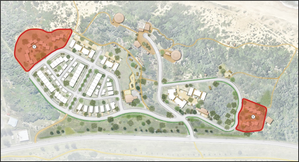 Figure E6.09: Dune edge cluster housing character areas
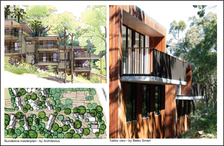
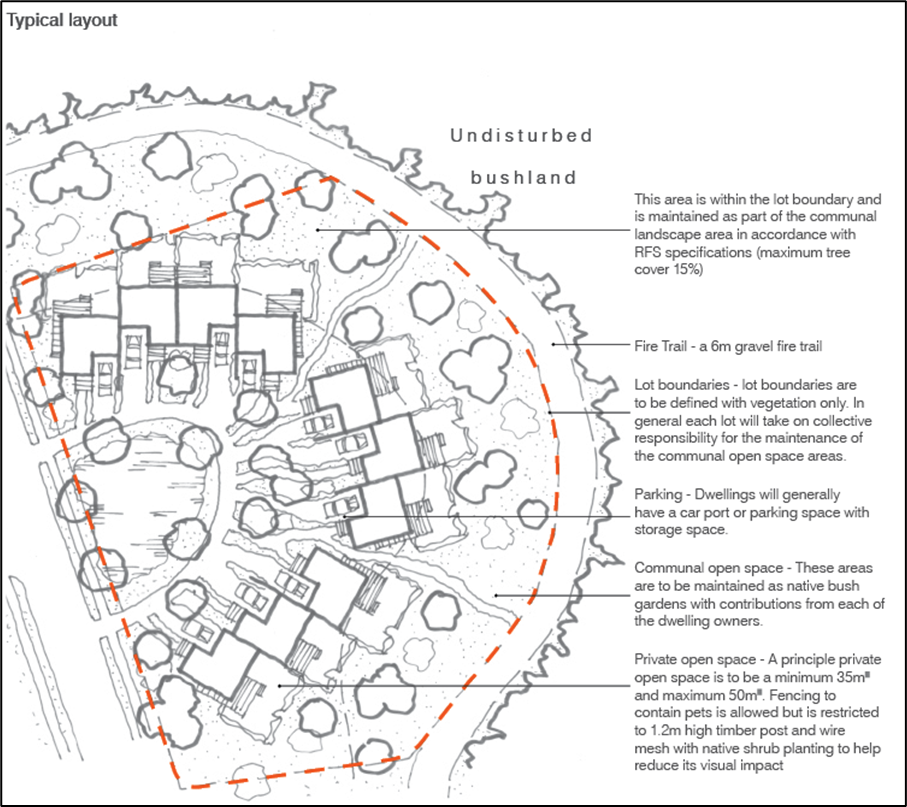 Figure E6.10: Area 1 Dune edge cluster housing typology
 Low-scale apartment precinct with predominately three storey apartment buildings with a coastal character, utilising natural materials, open air balconies and staggered building forms. Built form works with the site topography to minimise the appearance of building height and maintain key views to and from heritage items, particularly the Observation Tower.
Housing will generally be in accordance with the following precedent and guideline, unless an alternative proposal can demonstrate an improved outcome in line with the key design outcomes of this section.
Key design outcomes
Description: The apartments are designed to minimise overall building footprint and bulk and maximise visual connections with the surrounding landscape. Small footprints allow for up to four units per floor with the potential to allow for open undercroft spaces at ground floor and open stairwells and vertical circulation.
Indicative dwelling yield: 42 dwellings.
Maximum site coverage: 65%.
Minimum landscaped area: 35%.
Front setback: 3m.
Construction: Steel frame concrete slab, skillion/vaulted roofs.
External materials: Combination of corrugated metal sheet, timber panel cladding.
Sustainability: Passive solar design, locally sourced materials, naturally ventilated, high thermal performance, rain water harvesting, solar PV cells, minimise cut and fill, native drought tolerant species.
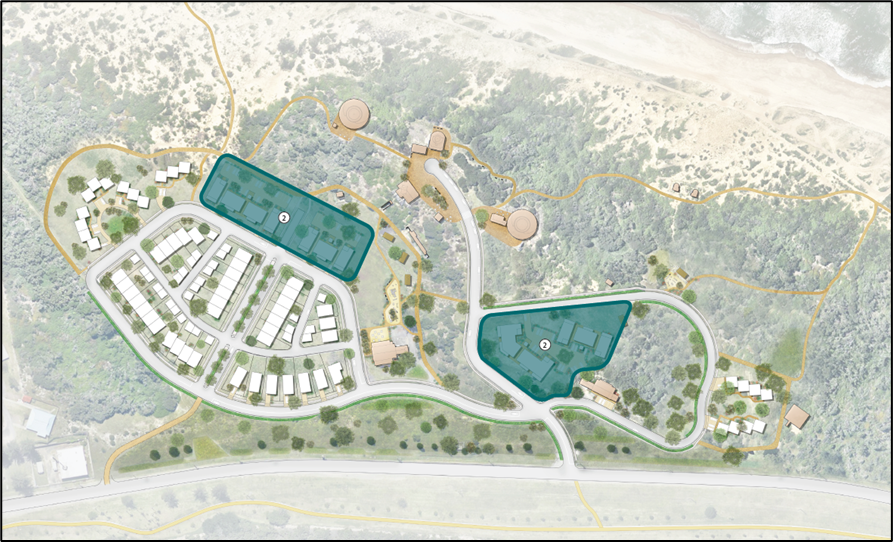 Figure E6.11: Low scale coastal apartment living character areas
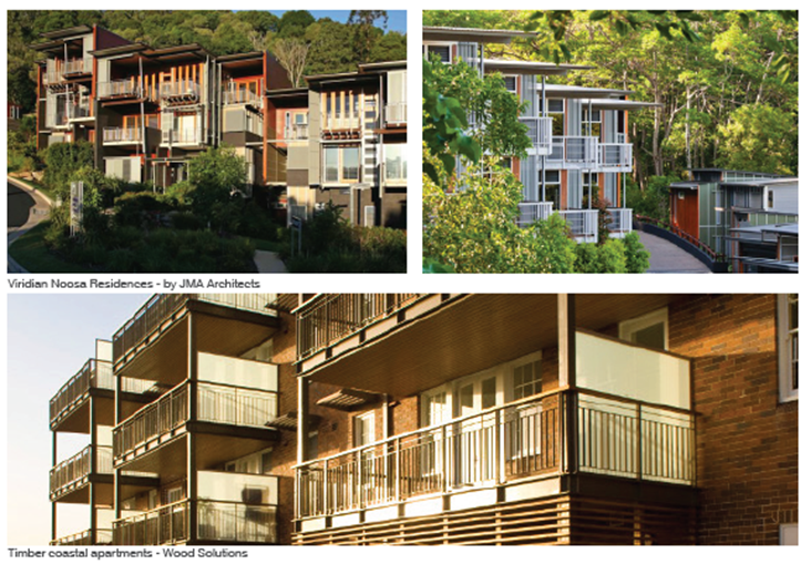
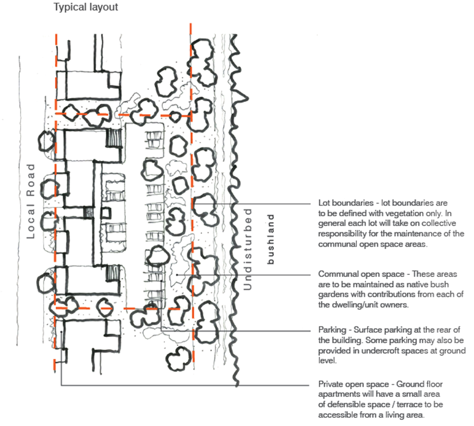 Figure E6.12: Area 2 low scale coastal apartment living typology
 This precinct has a denser urban character in the central development area with a more traditional subdivision and street layout. This precinct will provide attached and semi-detached housing with high quality, well designed private areas that make the most efficient and effective use of space, serviced by rear lanes. Housing should be a mix of courtyard housing and attached housing.
Housing will generally be in accordance with the following precedent and guideline, unless an alternative proposal can demonstrate an improved outcome in line with the key design outcomes of this section.
Indicative dwelling yield: 33 dwellings
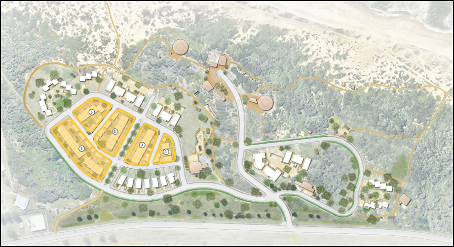 Figure E6.13: Courtyard and attached housing character areas
 Key design outcomes - courtyard housing
Description: This typology provides for a large family home including four bedrooms, three bathrooms, open plan living space, single garage and an ample rear garden. Dwellings are to be constructed on a zero lot line always on the same side with a 1.5m setback along the opposite boundary. This allows for a side pathway to access the rear garden and improves natural light and ventilation.
Maximum site coverage: 60% (all areas under the roof, including secondary dwellings and garages and all impermeable surfaces).
Minimum landscaped area: 40%.
Front setback: 3m.
Construction: Steel or timber frame on concrete slab, skillion/vaulted roof.
External materials: Combination of corrugated metal sheet, timber panel cladding and rendered masonry.
Sustainability: Passive solar design, locally sourced materials, naturally ventilated, high thermal performance, rain water harvesting, solar PV cells, minimise cut and fill, native drought tolerant planting.
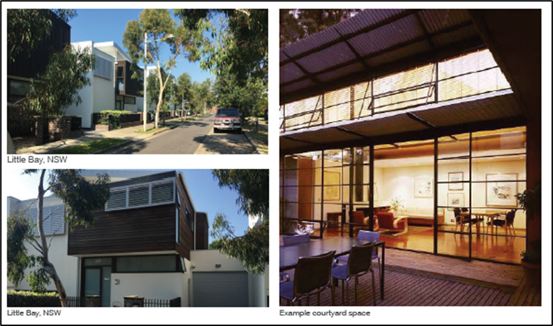
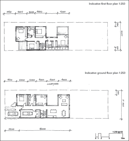 Figure E6.14: Courtyard housing typology
Key design outcomes - attached housing
Description: These 3 bedroom homes provide compact attached dwellings in locations where increased densities are appropriate. The rear lane access allows the front elevation of the house to be free from garage doors and parked cars which promotes good natural surveillance and an attractive street frontage. Above the rear double garage it is possible to have a secondary dwelling or ‘fonzie flat’ that provides a self-contained studio apartment that can provide additional family or guest accommodation, home occupation or rental return. The ‘fonzie flat’ also activates the laneway increasing safety and security through natural surveillance.
Maximum site coverage: 65% (all areas under the roof, including secondary dwellings and garages and all impermeable surfaces).
Minimum landscaped area: 35%.
Front setback: 3m.
Construction: Steel or timber frame on concrete slab, skillion/vaulted roof.
External materials: Combination of corrugated metal sheet, timber panel cladding and rendered masonry.
Sustainability: Locally sourced materials, naturally ventilated, high thermal performance, rain water harvesting, solar PV cells, minimise cut and fill, native drought tolerant planting.
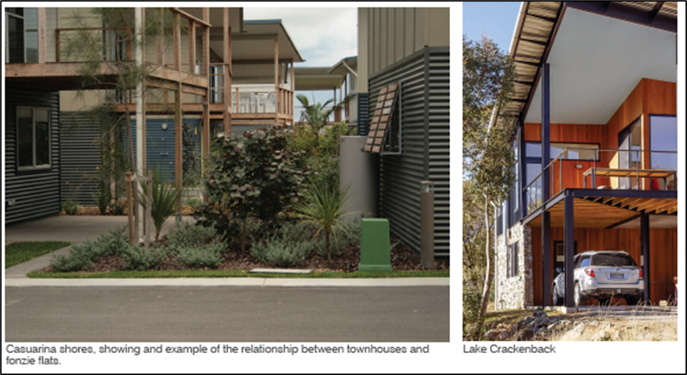
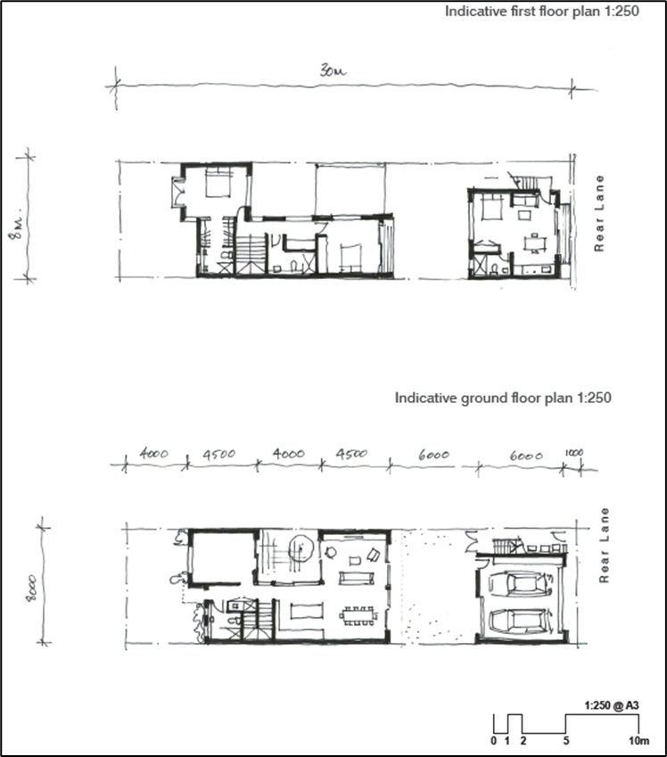 Figure E6.15: Attached housing typology
 Single, low scale detached dwelling houses with a focus on sustainable living and integration with the natural environment.
Housing will generally be in accordance with the following precedent and guideline, unless an alternative proposal can demonstrate an improved outcome in line with the key design outcomes of this section.
Key design outcomes
Description: These homes are intended to be lightweight, climate responsive individual homes set within generous lots that are managed and maintained to contribute to the overall natural characteristics of the estate.
Indicative dwelling yield: Seven dwellings.
Maximum site coverage: 50% (all areas under the roof, including secondary dwellings and garages and all impermeable surfaces).
Minimum landscaped area: 50%.
Front setback: 5m.
Construction: Steel or timber frame with suspended composite concrete slab, skillion/vaulted roof.
External materials: Combination of corrugated metal sheet, timber panel cladding.
Sustainability: Passive solar design, locally sourced materials, naturally ventilated, high thermal performance, rain water harvesting, solar PV cells, minimise cut and fill, native drought tolerant species.
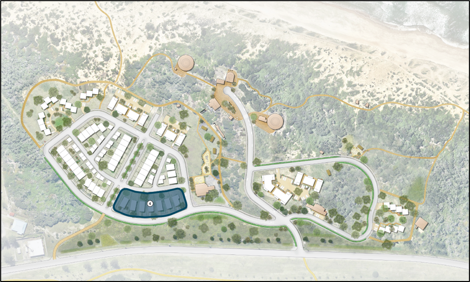 Figure E6.16: Single detached eco-living character areas
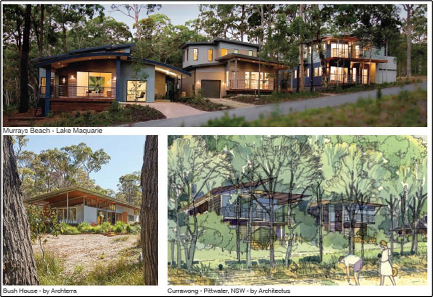
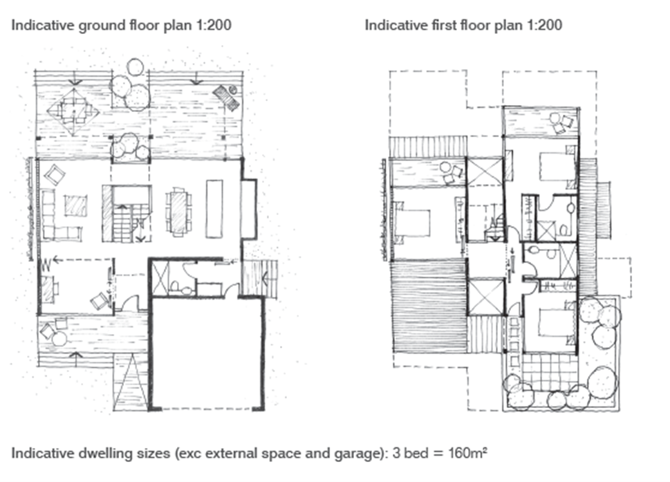 Figure E6.17: Single detached eco-living typology
 Performance criteria
- The amenity of residential development and wellbeing of the Fort Wallace community is supported by both high quality and appropriate open spaces.
- Open spaces are well designed, consider safety and provide opportunities for a range of activities.
- Open spaces are to be well connected and have potential to further connect with open space networks along the peninsula.
- Open spaces protect and celebrate the heritage of Fort Wallace by interpretation and appropriate landscape buffers between heritage items and development.
Acceptable solutions
- The location and design of new open space is provided in accordance with Figure E6.18.
- Access and connections will be provided in accordance with Figure E6.22.
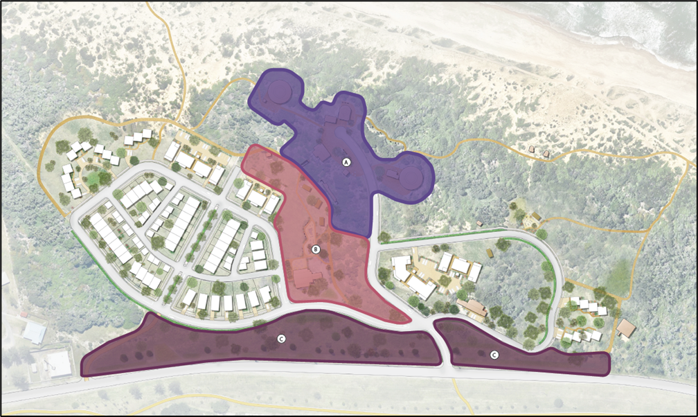 Figure E6.18: Landscape and open space hierarchy
 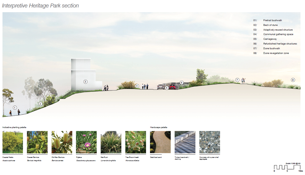 Figure E6.19: Indicative heritage precinct section
 Area A – Heritage precinct
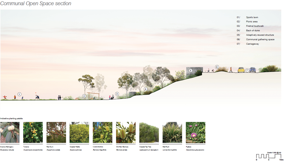 Figure E6.20: Indicative park section
 Area B – Park
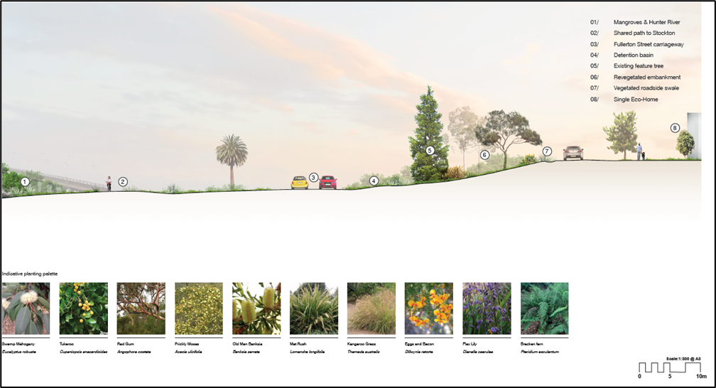 Figure E6.21: Frontage to Fullerton Street section
 Area C – Fullerton Street
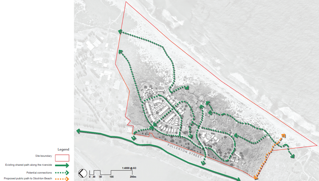 Figure E6.22: Access and connections
 This section refers to bushfire risk, future connections, heritage, important views and off street car parking.
Performance criteria
- The location and design of dwellings respond to bushfire risk.
- Asset protection zones are designed and maintained to balance fuel reduction, a landscaped setting for dwellings and biodiversity.
- Clear and equitable management of asset protection zones.
Acceptable solutions
- Asset protection zones are provided in accordance with Figure E6.23.
- Timber or timber-look products treated to meet Australian Standards for the relevant bushfire attack level (BAL rating) are used.
- Asset protection zones are designed to manage fuel loads and maintain structure of an open, non-connected tree canopy, spaced large trees, with shrub gardens as islands.
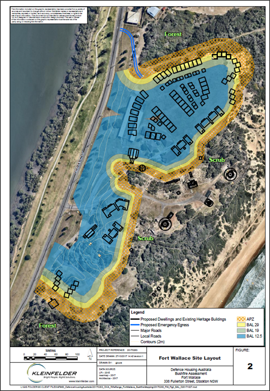 Figure E6.23: Asset protection zone
 Performance criteria
- Development appropriately responds to heritage items on the site.
- Development facilitates an appreciation of the heritage items individually and as a whole.
- Development facilitates the appropriate management of the site’s heritage values into the future.
- To identify and manage any potential impacts on Aboriginal cultural heritage.
Acceptable solutions
- A built form development buffer is maintained to heritage items as shown in Figure E6.24.
- Consideration is given to views to and from heritage items on the site from open spaces (see Figure E6.25 and Figure E6.26) in the massing and design of buildings and landscaping.
- Heritage items form part of an integrated open space plan for the site.
- Development of the site is undertaken in accordance with recommendations of an Aboriginal Cultural Heritage Management Plan prepared for the site accompanying a Stage 1 DA.
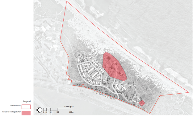 Figure E6.24: Development buffer to heritage items
 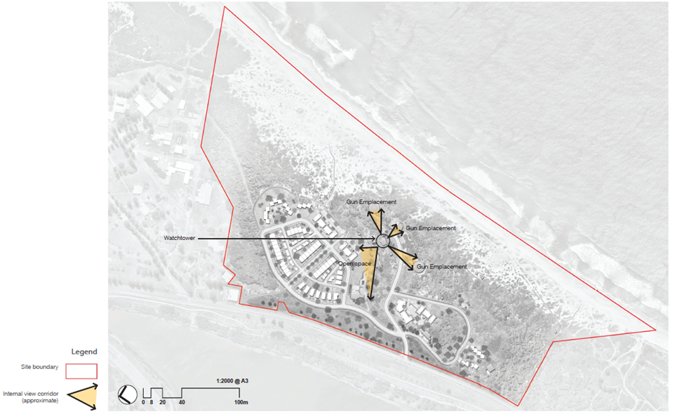 Figure E6.25: Internal view corridors
 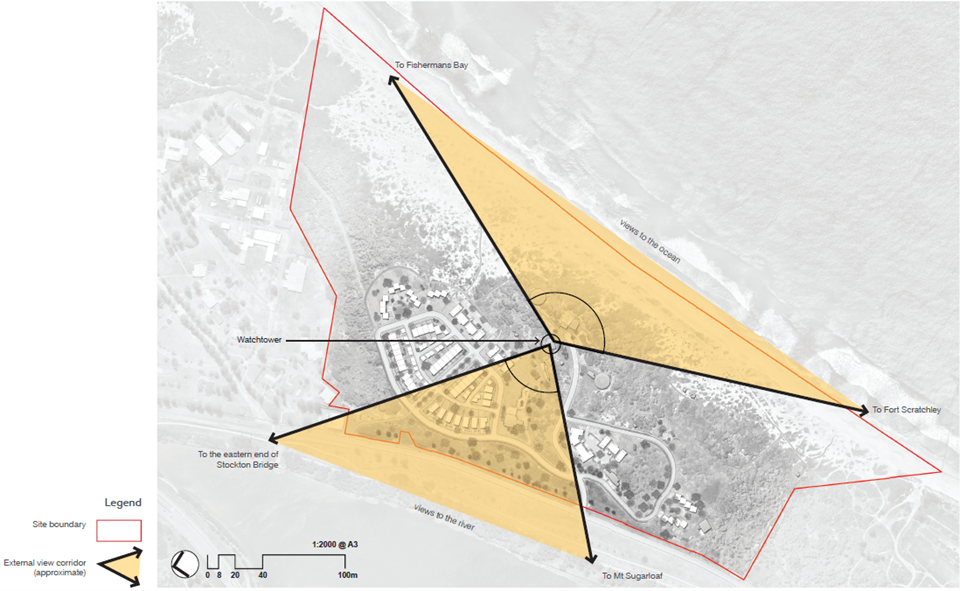 Figure E6.26: External view corridors
 Performance criteria
- Car parking associated with development has a low visual impact.
- Earthworks and disruption to the site ecology are minimised.
Acceptable solutions
- Car parking is provided at grade.
- Car parking is located to the rear of properties.
- Basement car parking is not provided.
Performance criteria
- Fencing is minimised across the site.
- Fencing has low visual impact.
- Pet ownership is to be controlled within the development.
Acceptable solutions
- Landscaping is used to delineate the boundary between private and communal spaces as an alternative to fencing.
- Where fences are needed for adequate management of land and pets or safety, fencing is a maximum 1.2m high timber post and wire mesh with native shrub planting.