Section E7 Wickham
This section provides detailed standards and guidance for development in order to implement the Wickham Master Plan (2017) and the changes adopted through the Wickham Masterplan (2021 Update).
It integrates place-based planning and design guidelines to inform future redevelopment, consistent with the vision of the area as set out in the Wickham Masterplan (2021 Update), in particular the characteristic features of each of the five identified interconnecting precincts (Key Precincts) within Wickham.
This section provides performance criteria that explain the planning outcomes to be achieved. Accompanying the performance criteria are acceptable solutions that illustrate the preferred way of complying with the performance criteria. There may be other ways of meeting the performance criteria and it is up to the applicant to demonstrate how the performance criteria are met.
This section applies to all development consisting of:
- New buildings or structures
- Additions or alterations to existing buildings or structures
- Subdivision.
This section applies to all land within the heavy line marked up on Figure E7.01.
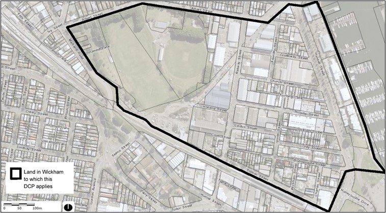 Figure E7.01: Wickham
The following sections will also apply to development:
The following sections may also apply to development:
- B1(a) Flood management - pre 2019 flood studies
- B1(b) Flood management - post 2019 flood studies
- B2 Bush fire protection
- B3 Mine subsidence
- B4 Aboriginal cultural heritage
- B5 Historical archaeology
- B7 Land contamination
- C1 Traffic, parking and access
- C2 Movement networks
- C3 Vegetation preservation and care
- C4 Stormwater
- C5 Soil management
- C6 Waste management
- C7 Safety & security
- C8 Social impact
- C9 Advertising and signage
- C10 Street awnings and balconies
- C11 Development adjoining laneways
- C12 Open space and landscaping
- C13 Liveable housing
- D1 Subdivision and lot consolidation
- D2 Single dwelling and ancillary development
- E1 Built and landscape heritage.
- Guide the evolution of Wickham from a semi-industrial area at the outer fringe of Newcastle City Centre into a mixed use urban neighbourhood supporting the emerging commercial core within Newcastle West.
- Ensure development is consistent with the intended future character of each urban precinct.
Development category | Application requirements | Explanatory notes |
All applications that include the erection of a new structure or the extension of an existing structure with a height exceeding 10m are to be accompanied with a 3D model of the proposed development within the context of the Newcastle CBD 3D model. | The format should be compatible to that used by City of Newcastle (CN). Format specification requirements for the model can be provided by CN's Geospatial Information Services team.
| The 3D Model should be used to illustrate the following information:
|
All applications on land identified within the Newcastle Mine Subsidence District | All applications will need to be assessed on application by Mine Subsidence NSW. CN advises prospective applicants to first contact Subsidence Advisory NSW to gain an understanding of the potential risks, limitations and financial costs associated with developing over the old mine workings. | Due to the nature of the old mine workings in the area, redevelopment is likely to include significant and costly engineering controls including extensive grouting. |
Wickham will continue to evolve from a semi-industrial area at the outer fringe of Newcastle City Centre into a mixed use urban neighbourhood supporting the emerging commercial core within Newcastle West.
Urban renewal is envisaged to build on the existing urban structure to deliver greater connectivity, improved public domain amenity and built form which reflects the function and character of the area.
Urban precincts
The controls applying to this section are based on achieving the intended future character of each urban precinct, as identified in Figure E7.02, consistent with the vision of the Wickham Masterplan (2021 Update).
Any variation to the 'acceptable solutions' proposed as an alternative means of meeting the specific 'performance criteria,' will need to be justified having regard to achieving the future character of the relevant precinct.
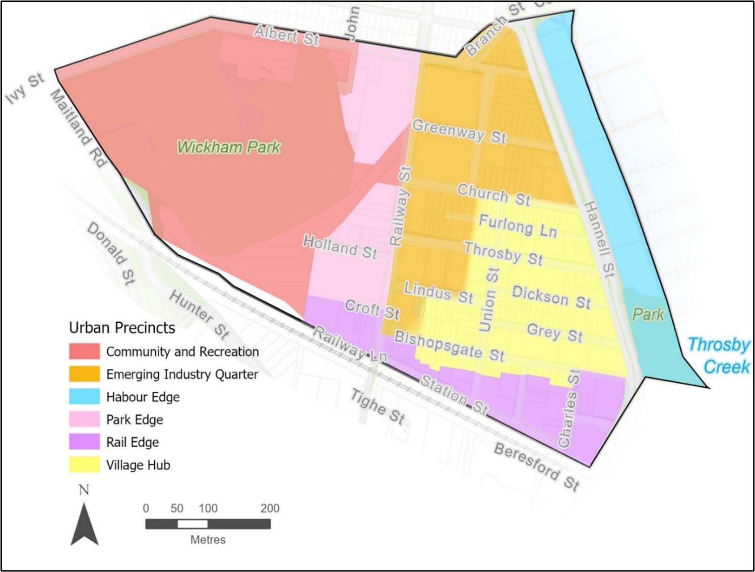 Figure E7.02: Urban precincts
A. Rail Edge
Existing character
The majority of this precinct has already been redeveloped given the proximity to the Transport Interchange and the already generous development standards.
The Rail Edge precinct is predominantly characterised by higher density residential development with a mix of uses at street level. The larger podium tower building types reflect the precinct's location at the interface to the emerging commercial core of Newcastle West.
Future character
The precinct is envisaged to support high density residential development that capitalises on its location adjacent to Newcastle Transport Interchange and provides ground level commercial uses with neighbourhood level retail and services activating street corners. Building scale and form transitions down to integrate with the lower scale Village Hub precinct fronting Bishopsgate Street.
B. Village Hub
Existing character
The Village Hub retains much of the original residential subdivision patterns established in the 1800s, characterised by narrow streets and a mix of lower scale residential building typologies. Buildings are set back from the front boundary and the front setback typically contains landscaping and forecourts.
The existing scale of the precinct allows for three storey buildings. The building height along the southern side of Bishopsgate Street is currently 24m.
Future character
Redevelopment and infill development is envisaged to continue to include terrace style housing, shop top housing and smaller residential apartment buildings. A street wall height is anticipated to be up to three storeys along each street fronting setback, incorporating design elements that complement that of existing housing stock.
Redevelopment of small residual sites for infill housing will also enable urban renewal where amalgamation of sites is not possible or unlikely to result in increased residential densities.
Modifications to existing dwellings in the Village Hub should be sympathetic to the original architectural features of the building style.
Opportunities for onsite car parking and driveway access are limited to ensure priority to pedestrian amenity and safety.
Union Street provides the main north-south pedestrian connection with wide footpaths and street trees, linking the predominantly residential precinct to the Newcastle Transport Interchange. Retail and commercial activity are focused on corner sites along Union Street while the east-west orientated streets maintain a residential focus, except for Throsby Street, which continues to support a mix of business uses at street level.
The interface to the adjoining Emerging Industry Quarter precinct mid-block along Bishopsgate, Church, Lindus and Throsby Streets focuses on creating a consistent character along the street edge by continuation of identified front setbacks, landscape provision, use of design elements that emphasise the lower levels, with upper levels setback from the street.
Where additional building height is permissible in this precinct, the use of upper-level setbacks and design elements will ensure development presents at a consistent scale and character when viewed from street level. Tree planting and other landscape elements within urban activation areas of the public domain will also help to soften the visual dominance of larger development and improve the visual amenity for pedestrians.
 Figure E7.03: Envisaged character of the Village Hub based on permissible scale and densities
C. Harbour edge
Existing character
The precinct is characterised by predominately three storey buildings with uses that reflect the mixed residential, maritime, tourism and entertainment activities along Throsby Creek.
Future character
The Harbour Edge Precinct will continue to build on the recreational and economic opportunities in this prime waterfront location. This will be through intensification of uses that respect the Port of Newcastle's operational function and allowing for vistas and connections between Hannell Street and Throsby Creek.
The parkland at the southern end of this precinct will connect to the public domain areas of the final stage of the Honeysuckle redevelopment area.
D. Emerging industry quarter
Existing character
The Emerging Industry Quarter to the east of Railway Street extends to land north of Church Street due to its characteristically larger sites that accommodate a range of remnant light industrial buildings with high occupancy rates of employment uses including service industries, small scale niche manufacturing, research and development technologies.
Redevelopment within this precinct is likely to occur on land unrestricted by mine subsidence, based on the feasibility and availability of land for current businesses to relocate, particularly where owner-occupied.
Future character
Redevelopment is envisaged to foster business and employment generation, particularly on sites less conducive to residential amenity, such as Hannell Street and where residential densities are restricted by mine subsidence risk.
Where residential uses are accommodated within the precinct as part of a mixed-use development, the challenge is to ensure these provide genuine economic generating uses on ground level, rather than provision of a token commercial space sleeving at grade car parking.
Ground level floor areas are of an area and dimensions conducive to supporting a range of low impact and clean business uses, including high technology industries, manufacturing and creative industries.
Development on land within this precinct adjoining the Village Hub, will be designed to address the scale and character it presents along the streetscape, using architectural elements, articulation of setbacks and upper levels set further back from the street.
CN will seek to acquire the former rail corridor passing through this precinct to deliver a public space incorporating active transport that links to adjoining areas.
E. Park edge
Existing character
The Park Edge precinct is characterised by large sites containing commercial, light industrial, storage and warehouse uses backing onto the eastern side of Wickham Park.
Land within this Precinct is likely to redevelop within the next development cycle when market demand increases, particularly if the former rail corridor land is transformed into a useable public space with active transport links.
Future character
The Park Edge precinct is envisaged to transform into a mixed-use area including medium to high density residential development with building scales reflective of mine subsidence restrictions.
The precinct will activate the eastern edge of Wickham Park and provide natural surveillance to the active transport corridor diagonally dissecting the precinct. There are opportunities to improve public access through to Wickham Park with a key connection for pedestrians and cyclists being proposed through a widened Holland Street, the extension of Croft Street, the end of railway lane and a wide opening to the former Bullock Island rail corridor and through to Wickham Park on land opposite from Church Street along the western side of Railway Street.
F. Community and recreation
Existing character
This precinct combines land previously identified in WMP as ‘Wickham Park’ with part of the adjacent ‘Park Edge’, being the land known as the former Wickham to Bullock Island Railway Corridor. This land continues to act as a physical barrier between the City Centre and Wickham Park. The land contains some rail infrastructure along its southern extent, is partly leased to adjoining landowners along Railway Street but has otherwise remained vacant since it was last used as a works depot during the construction of the Newcastle Transport Interchange.
CN intends to acquire the majority of the former rail corridor land from its current owner, through its inclusion on the Land Reservation Acquisition (LRA) map in Newcastle Local Environmental Plan 2012 (LEP 2012).
Wickham Park continues to cater for the recreational and social needs of both local residents and the wider Newcastle community. CN will prepare a comprehensive plan of management for Wickham Park to improve amenity, connectivity, and surveillance, as identified in the WMP and reiterated within the Newcastle Strategic Sports Plan 2020.
Future character
The precinct will continue to cater for sporting, community events and festivals, which will benefit from improved pedestrian and cycle links to public transport and adjoining areas.
The former rail corridor will support active transport including shared pedestrian and cycleways extending from Maitland Road along a new roadway at the southern boundary of the precinct, to existing cycleways east of the intersection of Cowper and Hannell Streets at Throsby Creek, as shown in Map 4 - Traffic and Transport, Wickham Masterplan (2021 Update).
The rail corridor will include appropriate interpretive treatments acknowledging its local heritage listing within LEP 2012 and lined by distinctive planting to differentiate it from other street tree planting within the area.
Redevelopment of the larger triangle shaped part of the former railway corridor lands is significantly restricted due to former mine workings. If acquired by CN, this land will provide a vital role in supporting the precinct through provision of community facilities, formalised parking areas that can cater for both commuters and city workers during the week and park users on weekends, as well as infrastructure that supports a range of events and activities.
A. Setbacks to streets
Performance criteria
P1. Buildings setbacks define the street edge and public domain and reinforce the envisaged character of each precinct.
Acceptable solutions
A1. Ground level building setbacks to street boundaries are consistent with Figure E7.04.
A2. Where land is identified for acquisition by Council, in Figure E7.04, the minimum setback includes the land to be acquired plus any additional identified setback.
A3. Where building setbacks are not specified in Figure E7.04, buildings may be built to the street edge (zero setback) at ground level but only for:
- non-residential uses where the street facing facade has a minimum of 50% windows and /or other openings, or
- residential uses consisting of the covered private open space (outdoor living) component and where screened and/or elevated from the adjacent footpath/public domain area.
| Note: Further design criteria for development interface to the public domain are provided in sub-section 8.0 Urban Design. |
A4. The upper levels for any development in an identified Urban Precinct (Column 1), which is located at a height above that described in Column 2, is setback at the minimum distance identified in Column 3 from the street front boundary (measured along the horizontal) as identified in Table E7.01, below:
Urban precinct | Upper-level setback applies to any part of the building above the following height: | Minimum setback to street front (for the upper-level setback) |
Rail edge | 12m | 6m |
Village hub | 10m | 6m* |
Harbour edge | 12m | N/A |
Emerging industry quarter | 12m | 6m |
Park edge | 12m | 6m |
*Refer to A7 for land at 29 Bishopsgate Street.
Table E7.01: Upper level setbacks
| Note: Where the requirements of SEPP 65 and/or the Department of Planning and Environment's 'Apartment Design Guide' apply to development proposals subject to this section, any inconsistencies in minimum setbacks will be resolved by the greater of the two setbacks applying. |
Additional acceptable solutions applying to development within the Village Hub Precinct
A5. Within the Village Hub precinct development may encroach into the minimum street setback at the first level (i.e. second storey) for 50% of the frontage but only where the encroachment is for private open space such as a veranda, balcony, pergola or deck.
A6. Large scale development incorporates building articulation such that the building form is broken into smaller elements that relate to the fine grain pattern of development along Bishopsgate Street.
A7. Notwithstanding the upper level setbacks identified in A4, development on land at 29 Bishopsgate Street has an upper level setback of 15m from the street boundary for parts of the building above 10m.
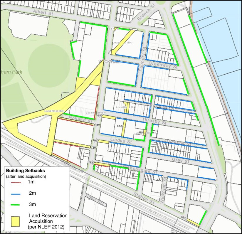 Figure E7.04: Ground level building setbacks to street boundaries
B. Setbacks to neighbouring sites
Performance criteria
P1. Side setbacks provide opportunity for landscaping and protect amenity to adjoining sites.
P2. Development provides natural surveillance to side and rear setback areas.
P3. Redevelopment within the Harbour Edge precinct provides for public access and views to Throsby Creek.
Acceptable solutions for all precincts, except the Village Hub
A1. Development may be built to the side boundary (zero setback) for a height up to 8.5m where a landscaped setback of at least 3m from the side boundary is provided within the first 6m from any street fronting boundary, as shown in Figures E7.05 and E7.06.
A2. The landscaped side setback (described above):
- consists of deep root planting with suitable trees, shrubs and groundcovers; and
- is visible from adjoining uses (within the site) through the placement of windows and open space areas.
A3. Development adjoining the Village Hub precinct has an upper level setback for any part of the development above 12m, of 8m to the side or rear boundary that adjoins the Village Hub precinct.
Additional acceptable solutions for the Harbour Edge precinct
A4. Development provides pedestrian and cycling links between Hannell Street and Throsby Creek.
A5. Built form within the Harbour Edge precinct enables view lines to Throsby Creek from the east-west orientated streets to the west of Hannell Street.
| Note: Applicants for development within the Harbour Edge precinct are advised to engage with Port of Newcastle prior to lodgement regarding the location and requirements for maintaining navigation aids in this locality to ensure the safe and efficient operation of the Port. |
Additional acceptable solutions for the Village Hub precinct
A6. Development within the Village Hub that has a building height greater than 10m, has an upper level setback for any part of the development above 10m of 8m to the side or rear boundary of any land that is also within the Village Hub precinct.
.jpg&hash=1e8b39d45b495e35824eded21275712c8c8d523c87ba5263d1319efab2dbad35) Figure E7.05: Example of building envelopes with no setback to street front (zero setback)
Figure E7.05: Example of building envelopes with no setback to street front (zero setback) Figure E7.06: Example of building envelopes with front setback to street boundary
C. 3D model application requirement
Performance criteria
P1. All applications that include the erection of a new structure or the extension of an existing structure with a height exceeding 8.5m are to be accompanied with a 3D model of the proposed development.
Acceptable solutions
A1. See sub-section 5.0 application requirements for further information.
D. Isolated sites
Performance criteria
P1. Development:
- enables suitable development of existing isolated sites in a matter which responds to the site context and constraints and maintains a high level of amenity for future occupants and neighbours.
- avoids the creation of isolated sites as a result of the development of adjoining lots.
Acceptable solutions
A1. Development is not to result in the creation of an isolated site that could have been developed in compliance with the relevant planning controls. Appropriate documentary evidence to demonstrate that a genuine and reasonable attempt has been made to purchase an isolated site based on a fair market value.
A2. Where amalgamation of the isolated site is not feasible, applicants will be required to demonstrate that an orderly and economic use and development of the separate sites can be achieved.
A3. The development of existing isolated sites is not to detract from the character of the streetscape and is to achieve a satisfactory level of amenity including solar access, visual and acoustic privacy. Development of existing isolated sites may not achieve the maximum potential, particularly height and floor space ratio, and will be assessed on merit.
| Note: Reasonable offers to purchase a site that is to be isolated are to be made at an early stage before DA lodgement. However, where an applicant has failed to negotiate before a DA was lodged, it is not necessarily too late to do so after lodgement. Documentation is required to demonstrate in writing that an offer to purchase has been made to the owner(s) of the isolated lot and the owner has refused to negotiate. A licensed valuer must base the offer on at least one recent independent valuation. |
| Note: Development that would result in the creation of an isolated lot must comply with the planning principles established by the Land and Environment Court in Melissa Grech v Auburn Council [2004] NSWLEC 40, Cornerstone Property Group Pty Ltd v Warringah Council [2004] NSWLEC 189; Karavellas v Sutherland Shire Council [2004] NSWLEC 251; provide for a future extension incorporating the isolated lot, or demonstrate that the isolated lot can be developed independently. |
A. Public domain
Performance criteria
P1. Enhance public domain amenity and maximise opportunities for movement, walking and cycling.
Acceptable solutions
A1. All development must upgrade the public domain for the full width of all site frontage to CN specifications. Where the proposed works will adjoin and connect into existing or approved works on an adjoining site, then suitable transitions are required beyond the property frontage.
Explanatory note
E1. When determining the requirement for public domain works, considerations by CN may include, but are not limited to the following:
- the development type, scale and density
- planned or likely intensification of an area
- adjoining or surrounding footpath infrastructure and surface treatments
- condition of any existing footpath and need for replacement
- CN forecasted infrastructure and asset projects or capital works programs
- topography of the road reserve along subject site frontage
- the presence of any utilities, services, assets, street trees, street furniture or the like
- CN public domain plans and standard drawings for footpaths
- consideration of heritage conservation principles.
B. Interface to the street
Performance criteria
P1. Ground level uses promote pedestrian activation of the public domain.
P2. Development facilitates natural surveillance of the public domain.
P3. Building form reflects the envisaged precinct character and takes design cues from existing built elements within the streetscape.
Acceptable solutions
A1. The following design elements are incorporated in development facing a street or public domain area:
- building name and/or street number signage are easily identifiable
- building entries are well-lit
- individual ground floor uses have direct pedestrian access to the footpath
- universal access is provided to non-residential ground floor uses where the finished floor level is above or below the footpath
- non-residential ground floor uses are visible from the street
- the floor level of residential ground floor uses may be elevated not more than 1m above the footpath
- building street setbacks incorporate gardens and/or landscaped forecourts, and
- green walls and/or street art (e.g., murals) are provided to reduce and/or break up non active building facades (i.e., blank walls, screened areas, services and utility cabinets, and/or garage doors).
- Ground floor residential fences are to be no more than 1.2m in height with a minimum 50% transparency. Soft landscaping is encouraged. Colourbond must be avoided.
- Avoid hardstand in the front setback, instead provide landscaping.
A2. Development on corner sites activate at least 50% of each facade.
A3. Residential development at ground level has a minimum 4m ceiling height and is designed to enable change of use in the future.
C. Urban activation spaces
Performance criteria
P1. Development incorporates space that provides relief from the hard surfaces of the urban environment and for residents and the local community to gather or participate in activities.
Acceptable solutions
A1. Urban activation spaces are located:
- in central locations along identified pedestrian and cycle routes and at street corners as identified in Figure E7.10
- within the front setback of larger development sites and partly incorporated into the road reserve
- adjoining supporting retail or community activities that provide natural surveillance, but do not commercialise the space for their own business.
A2. Urban activation spaces incorporate landscape elements or facilities as identified in the Wickham Community Infrastructure Plan.
 Figure E7.07: Urban activation space examples
 Figure E7.08: Location of urban activation spaces
D. Vehicle access to land
Performance criteria
P1. Vehicle and service entries ensure the safety and amenity of pedestrians.
Acceptable solutions
A1. Vehicle access and service entries are located consistent with Figure E7.09.
A2. Driveway crossings are consolidated or eliminated along the primary frontage of new developments.
Acceptable solutions - Village Hub
A3. For development consisting of two or more dwellings, on-site car parking is consolidated to minimise the number of driveways.
A4. Driveway access is single vehicle width at the footpath crossover.
 Figure E7.09: Vehicle access restrictions to new development
Design of parking structures
Performance criteria
P1. Parking structures are integrated into new buildings and are not visually prominent from the public domain.
P2. The design and construction method of at grade and above ground car parking areas enable adaptable reuse in the future for residential or commercial uses.
P3. Car parking areas are able to be adapted in response to changing future transport mode or demands.
Acceptable solutions
A1. All parking is located within the building footprint, either in a basement or integrated into the building.
A2. Ground level or above ground parking areas are not visible from the public domain by:
- being located behind other uses, or
- using green walls and roofs, or
- using architecturally designed façade treatment or artwork.
A3. Car parking is located on level flooring and has a minimum ceiling height of:
- 4m where located on ground level, and
- 3m where located on any upper levels.
Performance criteria
P1. In accordance with Clause 7.11 of LEP 2012 an incentive height of building and floor space ratio may be achievable on land where CN and an applicant have agreed to or entered into a planning agreement on the basis of providing identified community infrastructure.
P2. Community infrastructure may be provided to CN in the form of land, capital works, cash contribution, or a combination of these that will deliver the nominated community infrastructure projects identified in the Wickham Community Infrastructure Plan.
P3. Applicants will obtain in-principle agreement from CN to the provision of community infrastructure being offered prior to lodging a formal DA.
Explanatory note
E1. Community infrastructure is identified in the Wickham Community Infrastructure Plan. It includes development for the purpose of community facilities, recreation areas, recreation facilities (outdoor) or public roads.
E2. The 'Incentive GFA Rate for Wickham' is identified in the Wickham Community Infrastructure Plan and is subject to indexation.
E3. A planning agreement is the means by which identified community infrastructure will be delivered on a given site. This community infrastructure is provided in addition to infrastructure contributions payable under Section 7.11 and Section 7.12 of the Environmental Planning and Assessment Act 1979.
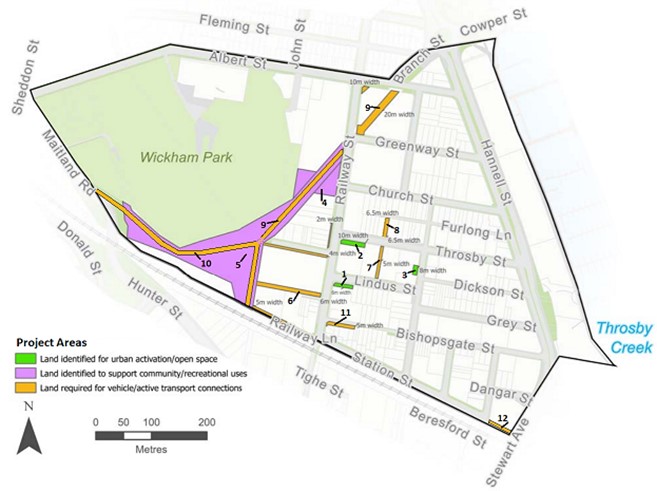 Figure E7.10: Location of community infrastructure projects in Wickham